TopoQuest Logo
Do you find TopoQuest useful?
Help keep TopoQuest running and adding new maps/features by donating!
Bitcoin:  19c7KJd3qBynnjoSw5npx9KScwjBe4ifkT
Litecoin:  LXs6TkuXGGXo1vDsWCkWVdjQX94eUKd6ui
Home View Maps Find Maps Find Places Resources & Links


O Bar O Canyon West, New Mexico Topographic Map

USGS Map Title: O Bar O Canyon West, NM
USGS Map MRC: 33108E3
DRG (GeoTIFF) Download: o33108e3.tif


Neighboring USGS Topographic Map Quads:


  Collins Park, NM  
33108F4
 

  Salvation Peak, NM  
33108F3
 

  Rail Canyon, NM  
33108F2
 

  Pitchfork Canyon, NM  
33108E4
 

  O Bar O Canyon West, NM  
33108E3
 

  O Bar O Canyon East, NM  
33108E2
 

  Loco Mountain, NM  
33108D4
 

  Canyon Creek Mountains, NM  
33108D3
 

  Black Mountain, NM  
33108D2


Map MRC Location:

N34°
W109°
N34°
W108°
H8 H7 H6 H5 H4 H3 H2 H1
G8 G7 G6 G5 G4 G3 G2 G1
F8 F7 F6 F5 F4 F3 F2 F1
E8 E7 E6 E5 E4 E3 E2 E1
D8 D7 D6 D5 D4 D3 D2 D1
C8 C7 C6 C5 C4 C3 C2 C1
B8 B7 B6 B5 B4 B3 B2 B1
A8 A7 A6 A5 A4 A3 A2 A1
N33°
W109°
N33°
W108°

O Bar O Canyon West, NM USGS 1:24K Topographic Map Preview:
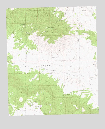
O Bar O Canyon West, NM USGS Topographic Map
Click on map above to begin viewing in our Map Viewer.

This topographic map contains these locations and features:
Feature Name Type Latitude Longitude GNIS ID View Map
Brushy TankReservoirN33.5578°W108.2551°2038386View Map
Burl TankReservoirN33.6118°W108.2921°1848243View Map
Continental Divide National Scenic TrailTrailN33.6067°W108.3481°2038812View Map
Deer TankReservoirN33.5106°W108.2645°2038436View Map
Divide TankReservoirN33.6059°W108.3540°1848239View Map
Government TankReservoirN33.6239°W108.2539°1848235View Map
Horse Camp TankReservoirN33.5234°W108.2941°1848234View Map
J J Pit TankReservoirN33.5104°W108.3384°1848228View Map
Jamie TankReservoirN33.5668°W108.3088°1848232View Map
Jiggs TankReservoirN33.5747°W108.2785°1848237View Map
Kimo TankReservoirN33.5814°W108.2979°1848236View Map
Mesa Redonda CanyonValleyN33.5556°W108.2542°1848240View Map
Mesa Redonda SpringSpringN33.6026°W108.3148°908634View Map
Mesa Redonda TankReservoirN33.6010°W108.3140°1848241View Map
Middle Elk TankReservoirN33.5267°W108.3296°936653View Map
North TankReservoirN33.6168°W108.3131°1848242View Map
O Bar O MountainSummitN33.5945°W108.3142°909230View Map
O Bar O Mountain TankReservoirN33.5950°W108.3455°1848230View Map
O Bar O TankReservoirN33.5614°W108.3673°1848238View Map
Reliable TankReservoirN33.5486°W108.3601°1848229View Map
Sheep TankReservoirN33.5480°W108.3172°1848233View Map
Water Well TankReservoirN33.5451°W108.2862°936654View Map

Note: Coordinates in the location and feature list above are referenced to NAD83 datum.


Copyright (C) 2008-2025 Ryan Niemi / Sunset Dynamics ... All Rights Reserved