TopoQuest Logo
Do you find TopoQuest useful?
Help keep TopoQuest running and adding new maps/features by donating!
Bitcoin:  19c7KJd3qBynnjoSw5npx9KScwjBe4ifkT
Litecoin:  LXs6TkuXGGXo1vDsWCkWVdjQX94eUKd6ui
Home View Maps Find Maps Find Places Resources & Links


Batesville, Indiana Topographic Map

USGS Map Title: Batesville, IN
USGS Map MRC: 39085C2
DRG (GeoTIFF) Download: o39085c2.tif


Neighboring USGS Topographic Map Quads:


  Clarksburg, IN  
39085D3
 

  Metamora, IN  
39085D2
 

  Brookville, IN  
39085D1
 

  New Point, IN  
39085C3
 

  Batesville, IN  
39085C2
 

  Spades, IN  
39085C1
 

  Osgood, IN  
39085B3
 

  Pierceville, IN  
39085B2
 

  Sunman, IN  
39085B1


Map MRC Location:

N40°
W86°
N40°
W85°
H8 H7 H6 H5 H4 H3 H2 H1
G8 G7 G6 G5 G4 G3 G2 G1
F8 F7 F6 F5 F4 F3 F2 F1
E8 E7 E6 E5 E4 E3 E2 E1
D8 D7 D6 D5 D4 D3 D2 D1
C8 C7 C6 C5 C4 C3 C2 C1
B8 B7 B6 B5 B4 B3 B2 B1
A8 A7 A6 A5 A4 A3 A2 A1
N39°
W86°
N39°
W85°

Batesville, IN USGS 1:24K Topographic Map Preview:
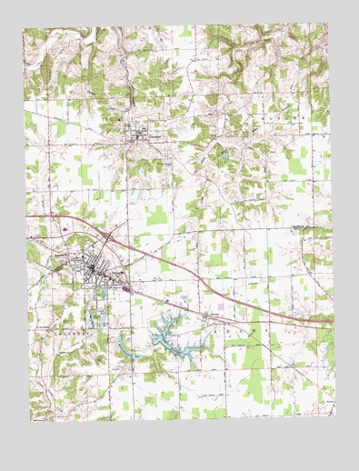
Batesville, IN USGS Topographic Map
Click on map above to begin viewing in our Map Viewer.

This topographic map contains these locations and features:
Feature Name Type Latitude Longitude GNIS ID View Map
BallstownPopulated PlaceN39.2506°W85.2441°430466View Map
BatesvillePopulated PlaceN39.3001°W85.2222°430573View Map
Batesville Fire DepartmentBuildingN39.2965°W85.2234°2701447View Map
Batesville Police DepartmentBuildingN39.2971°W85.2232°2758301View Map
Batesville Post OfficePost OfficeN39.3001°W85.2222°1759780View Map
Batesville Volunteer Fire and Rescue Department and Emergency Medical Services 10BuildingN39.2965°W85.2234°2625823View Map
Bischoff ReservoirReservoirN39.2762°W85.1947°431105View Map
Bischoff Reservoir DamDamN39.2742°W85.1991°447250View Map
Bobs CreekStreamN39.2598°W85.2422°431274View Map
City of BatesvilleCivilN39.2974°W85.2139°2394080View Map
Cross RoadsPopulated PlaceN39.2795°W85.2416°433187View Map
Eagle Fire Company of Oldenburg IndianaBuildingN39.3398°W85.2042°2626601View Map
Feller ReservoirReservoirN39.2845°W85.2182°434437View Map
Hahn ReservoirReservoirN39.2811°W85.2198°435590View Map
Hahn Reservoir DamDamN39.2801°W85.2216°447855View Map
Holy Family CemeteryCemeteryN39.3439°W85.2047°436351View Map
HuntersvillePopulated PlaceN39.3037°W85.2330°436629View Map
Kirschbaum School (historical)SchoolN39.3673°W85.1789°449766View Map
Liberty ParkParkN39.2909°W85.2208°437842View Map
Margaret Mary HealthHospitalN39.3051°W85.2225°2660526View Map
Mollenkramer ReservoirReservoirN39.2726°W85.2103°439316View Map
Mollenkramer Reservoir DamDamN39.2769°W85.2125°447856View Map
MorrisPopulated PlaceN39.2823°W85.1775°439444View Map
Morris Volunteer Fire DepartmentBuildingN39.2799°W85.1754°2626346View Map
OldenburgPopulated PlaceN39.3398°W85.2044°449704View Map
Oldenburg Elementary SchoolSchoolN39.3398°W85.2039°447133View Map
Oldenburg Police DepartmentBuildingN39.3398°W85.2042°2758196View Map
Oser ReservoirReservoirN39.2825°W85.2242°440722View Map
Ray School (historical)SchoolN39.3031°W85.2308°449768View Map
Saint Johns CemeteryCemeteryN39.3041°W85.2305°442571View Map
Saint Pauls CemeteryCemeteryN39.2822°W85.2364°442764View Map
Sorrowful Mother ShrineChurchN39.3306°W85.1905°443772View Map
Strausburg School (historical)SchoolN39.3528°W85.1472°449765View Map
Sugar CreekStreamN39.3706°W85.2208°449767View Map
Sycamore LakeReservoirN39.2992°W85.2303°444514View Map
Town of OldenburgCivilN39.3387°W85.2040°2396831View Map
Township of AdamsCivilN39.2667°W85.1405°453081View Map
Township of RayCivilN39.3376°W85.2389°453782View Map
Tri - County AmbulanceBuildingN39.2957°W85.2153°2719350View Map

Note: Coordinates in the location and feature list above are referenced to NAD83 datum.


Copyright (C) 2008-2024 Ryan Niemi / Sunset Dynamics ... All Rights Reserved