TopoQuest Logo
Do you find TopoQuest useful?
Help keep TopoQuest running and adding new maps/features by donating!
Bitcoin:  19c7KJd3qBynnjoSw5npx9KScwjBe4ifkT
Litecoin:  LXs6TkuXGGXo1vDsWCkWVdjQX94eUKd6ui
Home View Maps Find Maps Find Places Resources & Links


Brookville, Indiana Topographic Map

USGS Map Title: Brookville, IN
USGS Map MRC: 39085D1
DRG (GeoTIFF) Download: o39085d1.tif


Neighboring USGS Topographic Map Quads:


  Alpine, IN  
39085E2
 

  Everton, IN  
39085E1
 

  New Fairfield, IN  
39084E8
 

  Metamora, IN  
39085D2
 

  Brookville, IN  
39085D1
 

  Whitcomb, IN  
39084D8
 

  Batesville, IN  
39085C2
 

  Spades, IN  
39085C1
 

  Cedar Grove, IN  
39084C8


Map MRC Location:

N40°
W86°
N40°
W85°
H8 H7 H6 H5 H4 H3 H2 H1
G8 G7 G6 G5 G4 G3 G2 G1
F8 F7 F6 F5 F4 F3 F2 F1
E8 E7 E6 E5 E4 E3 E2 E1
D8 D7 D6 D5 D4 D3 D2 D1
C8 C7 C6 C5 C4 C3 C2 C1
B8 B7 B6 B5 B4 B3 B2 B1
A8 A7 A6 A5 A4 A3 A2 A1
N39°
W86°
N39°
W85°

Brookville, IN USGS 1:24K Topographic Map Preview:
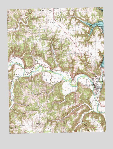
Brookville, IN USGS Topographic Map
Click on map above to begin viewing in our Map Viewer.

This topographic map contains these locations and features:
Feature Name Type Latitude Longitude GNIS ID View Map
Blue CreekStreamN39.3951°W85.0108°431220View Map
Boundary HillSummitN39.4434°W85.0355°431380View Map
BrookvillePopulated PlaceN39.4231°W85.0127°431586View Map
Brookville Elementary SchoolSchoolN39.4264°W85.0111°446503View Map
Brookville Police DepartmentBuildingN39.4213°W85.0130°2758114View Map
Brookville Volunteer Fire DepartmentBuildingN39.4244°W85.0084°2625687View Map
Butlers RunStreamN39.4262°W85.0180°449785View Map
Collett School (historical)SchoolN39.4417°W85.0713°449773View Map
Deer CreekStreamN39.4051°W85.1208°433421View Map
Duck CreekStreamN39.4431°W85.1241°433746View Map
Duck Creek School (historical)SchoolN39.4787°W85.1247°449775View Map
East Fork Whitewater RiverStreamN39.4114°W85.0130°433904View Map
Ebenezer CemeteryCemeteryN39.4689°W85.0463°433971View Map
Elm Grove ChurchChurchN39.4192°W85.1233°434120View Map
Elm Grove School (historical)SchoolN39.4217°W85.1219°449772View Map
Flood Victims MemorialParkN39.4092°W85.0097°434608View Map
Franklin CountyCivilN39.4149°W85.0603°450352View Map
Franklin County Emergency Medical Services Station 2BuildingN39.4213°W85.0094°2719398View Map
Franklin County Sheriff's OfficeBuildingN39.4183°W85.0125°2758076View Map
Gates CreekStreamN39.4278°W85.1202°449776View Map
Goose CreekStreamN39.4414°W85.0805°435187View Map
Indian CreekStreamN39.4009°W85.1236°436735View Map
Laurence BranchStreamN39.4084°W85.1208°449793View Map
Long Acres BranchStreamN39.3831°W85.0786°449795View Map
Maple Grove CemeteryCemeteryN39.4217°W85.0216°438551View Map
McCartys RunStreamN39.4212°W85.0355°449796View Map
McKenzie CemeteryCemeteryN39.4667°W85.0925°438893View Map
MillvillePopulated PlaceN39.4492°W85.1236°452134View Map
Oak ForestPopulated PlaceN39.3848°W85.0852°440397View Map
Oak Forest ChurchChurchN39.3962°W85.0838°440398View Map
Philadephia Church (historical)ChurchN39.4667°W85.0922°449774View Map
Pipe CreekStreamN39.4323°W85.1041°441183View Map
Plum Grove ChurchChurchN39.4106°W85.0944°441370View Map
Plum Grove School (historical)SchoolN39.4181°W85.0686°449771View Map
Saint Michael SchoolSchoolN39.4170°W85.0111°446502View Map
Saint Michaels CemeteryCemeteryN39.4303°W85.0086°442735View Map
Saint Philomenas ChurchChurchN39.3851°W85.0847°442825View Map
Salt Well CreekStreamN39.4975°W85.0002°442944View Map
Silver CreekStreamN39.4317°W85.1102°449800View Map
Snail CreekStreamN39.4284°W85.0544°443722View Map
StavetownPopulated PlaceN39.4109°W85.0100°444102View Map
Town of BrookvilleCivilN39.4233°W85.0115°2396609View Map
Township of Blooming GroveCivilN39.4982°W85.0791°453114View Map
Township of BrookvilleCivilN39.4208°W85.0072°453136View Map
Trace BranchStreamN39.4181°W85.1225°444844View Map
Tracy School (historical)SchoolN39.3834°W85.0950°449770View Map
Whitewater CanalCanalN39.4520°W85.1127°445980View Map
Whitewater Canal MemorialParkN39.4520°W85.1127°447661View Map
Whitewater Canal Memorial LockDamN39.4470°W85.1239°452414View Map
Wolf CreekStreamN39.4820°W85.0138°446237View Map
Wolf CreekStreamN39.3984°W85.0180°446245View Map
Wolf Creek CemeteryCemeteryN39.3837°W85.0797°446246View Map
Yellow BankPopulated PlaceN39.4376°W85.0691°447630View Map
Yellow Bank CreekStreamN39.4362°W85.0622°446375View Map
Yellow Bank HillSummitN39.4562°W85.0722°446850View Map

Note: Coordinates in the location and feature list above are referenced to NAD83 datum.


Copyright (C) 2008-2024 Ryan Niemi / Sunset Dynamics ... All Rights Reserved