TopoQuest Logo
Do you find TopoQuest useful?
Help keep TopoQuest running and adding new maps/features by donating!
Bitcoin:  19c7KJd3qBynnjoSw5npx9KScwjBe4ifkT
Litecoin:  LXs6TkuXGGXo1vDsWCkWVdjQX94eUKd6ui
Home View Maps Find Maps Find Places Resources & Links


Osgood, Indiana Topographic Map

USGS Map Title: Osgood, IN
USGS Map MRC: 39085B3
DRG (GeoTIFF) Download: o39085b3.tif


Neighboring USGS Topographic Map Quads:


  Greensburg, IN  
39085C4
 

  New Point, IN  
39085C3
 

  Batesville, IN  
39085C2
 

  Millhousen, IN  
39085B4
 

  Osgood, IN  
39085B3
 

  Pierceville, IN  
39085B2
 

  Holton, IN  
39085A4
 

  Versailles, IN  
39085A3
 

  Milan, IN  
39085A2


Map MRC Location:

N40°
W86°
N40°
W85°
H8 H7 H6 H5 H4 H3 H2 H1
G8 G7 G6 G5 G4 G3 G2 G1
F8 F7 F6 F5 F4 F3 F2 F1
E8 E7 E6 E5 E4 E3 E2 E1
D8 D7 D6 D5 D4 D3 D2 D1
C8 C7 C6 C5 C4 C3 C2 C1
B8 B7 B6 B5 B4 B3 B2 B1
A8 A7 A6 A5 A4 A3 A2 A1
N39°
W86°
N39°
W85°

Osgood, IN USGS 1:24K Topographic Map Preview:
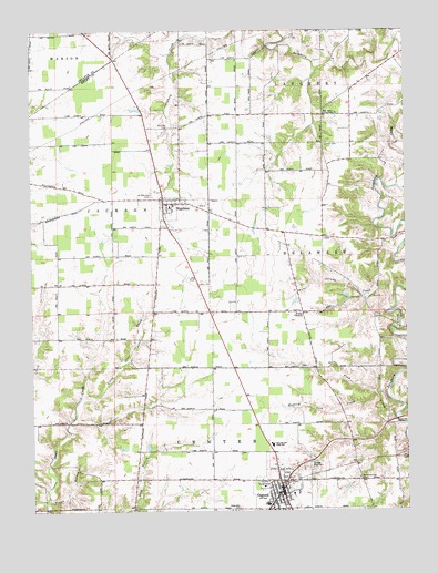
Osgood, IN USGS Topographic Map
Click on map above to begin viewing in our Map Viewer.

This topographic map contains these locations and features:
Feature Name Type Latitude Longitude GNIS ID View Map
Booher CemeteryCemeteryN39.2243°W85.3296°431331View Map
Finke ChurchChurchN39.1762°W85.2844°434487View Map
Hickory Lick CreekStreamN39.1545°W85.2608°436110View Map
Jac-Cen-Del Junior-Senior High SchoolSchoolN39.1420°W85.2950°436871View Map
Jericho CreekStreamN39.1770°W85.2550°436994View Map
LaugheryvillePopulated PlaceN39.2281°W85.2969°452132View Map
Little Otter CreekStreamN39.1548°W85.3589°438107View Map
NapoleonPopulated PlaceN39.2048°W85.3308°439935View Map
Napoleon Elementary SchoolSchoolN39.2042°W85.3283°447135View Map
Napoleon QuarryMineN39.2075°W85.3131°2649596View Map
Napoleon Volunteer Fire CompanyBuildingN39.2036°W85.3311°2626406View Map
New Salem Community ChurchChurchN39.2284°W85.2769°440114View Map
Old Salem CemeteryCemeteryN39.2203°W85.2772°442882View Map
OsgoodPopulated PlaceN39.1292°W85.2916°440723View Map
Osgood Elementary SchoolSchoolN39.1292°W85.2883°447136View Map
Osgood Police DepartmentBuildingN39.1289°W85.2920°2758099View Map
Osgood Volunteer Fire DepartmentBuildingN39.1314°W85.2942°2626358View Map
Perseverance CemeteryCemeteryN39.1331°W85.2661°441036View Map
Plum CreekStreamN39.1478°W85.2530°441363View Map
Ripley CreekStreamN39.2089°W85.2530°442057View Map
Saint Maurice CemeteryCemeteryN39.2073°W85.3348°442727View Map
Taylor BranchStreamN39.1276°W85.3705°444581View Map
Town of NapoleonCivilN39.2040°W85.3275°2396796View Map
Town of OsgoodCivilN39.1292°W85.2920°2396839View Map
Township of CenterCivilN39.1347°W85.3104°453191View Map
Township of JacksonCivilN39.1973°W85.3679°453464View Map
Vine SpringsLocaleN39.1439°W85.2688°449859View Map
Vine Springs Post Office (historical)Post OfficeN39.1439°W85.2688°453004View Map
WRBI-FM (Batesville)TowerN39.2228°W85.2577°448946View Map

Note: Coordinates in the location and feature list above are referenced to NAD83 datum.


Copyright (C) 2008-2025 Ryan Niemi / Sunset Dynamics ... All Rights Reserved