TopoQuest Logo
Do you find TopoQuest useful?
Help keep TopoQuest running and adding new maps/features by donating!
Bitcoin:  19c7KJd3qBynnjoSw5npx9KScwjBe4ifkT
Litecoin:  LXs6TkuXGGXo1vDsWCkWVdjQX94eUKd6ui
Home View Maps Find Maps Find Places Resources & Links


Logansport, Indiana Topographic Map

USGS Map Title: Logansport, IN
USGS Map MRC: 40086G3
DRG (GeoTIFF) Download: o40086g3.tif


Neighboring USGS Topographic Map Quads:


  Grass Creek, IN  
40086H4
 

  Fulton, IN  
40086H3
 

  Macy, IN  
40086H2
 

  Lucerne, IN  
40086G4
 

  Logansport, IN  
40086G3
 

  Twelve Mile, IN  
40086G2
 

  Clymers, IN  
40086F4
 

  Anoka, IN  
40086F3
 

  Onward, IN  
40086F2


Map MRC Location:

N41°
W87°
N41°
W86°
H8 H7 H6 H5 H4 H3 H2 H1
G8 G7 G6 G5 G4 G3 G2 G1
F8 F7 F6 F5 F4 F3 F2 F1
E8 E7 E6 E5 E4 E3 E2 E1
D8 D7 D6 D5 D4 D3 D2 D1
C8 C7 C6 C5 C4 C3 C2 C1
B8 B7 B6 B5 B4 B3 B2 B1
A8 A7 A6 A5 A4 A3 A2 A1
N40°
W87°
N40°
W86°

Logansport, IN USGS 1:24K Topographic Map Preview:
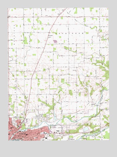
Logansport, IN USGS Topographic Map
Click on map above to begin viewing in our Map Viewer.

This topographic map contains these locations and features:
Feature Name Type Latitude Longitude GNIS ID View Map
AdamsboroPopulated PlaceN40.7845°W86.2669°449611View Map
Bethel Methodist CemeteryCemeteryN40.7861°W86.3119°430899View Map
Bethlehem ChurchChurchN40.8470°W86.3247°430984View Map
Broad Ripple BridgeBridgeN40.7678°W86.2900°431542View Map
Cass CountyCivilN40.7615°W86.3459°450339View Map
Cass County Sheriff's OfficeBuildingN40.7552°W86.3671°2758197View Map
Cass Station BridgeBridgeN40.7578°W86.2608°432218View Map
City of LogansportCivilN40.7502°W86.3559°2395746View Map
Columbia Middle SchoolSchoolN40.7625°W86.3706°432820View Map
DanesPopulated PlaceN40.7612°W86.2611°446700View Map
Daniel Webster Elementary SchoolSchoolN40.7573°W86.3381°445625View Map
Eel RiverStreamN40.7503°W86.3731°434037View Map
Emmanuel ChurchChurchN40.7625°W86.3200°434178View Map
Forgey DitchCanalN40.7737°W86.3647°434670View Map
Four County Counseling CenterBuildingN40.7623°W86.3633°2660457View Map
Gardner Powell DitchCanalN40.8348°W86.2958°434954View Map
Gault DitchCanalN40.8737°W86.3278°434997View Map
Hillcrest ChurchChurchN40.7737°W86.3733°436204View Map
Horney CemeteryCemeteryN40.7867°W86.3678°436485View Map
Howard DitchCanalN40.7809°W86.3086°436540View Map
Lake PerryReservoirN40.7684°W86.3150°447596View Map
Lake Perry DamDamN40.7684°W86.3150°447597View Map
Leases CornerPopulated PlaceN40.8664°W86.3742°437704View Map
Life TabernacleChurchN40.7734°W86.3675°437877View Map
LogansportPopulated PlaceN40.7545°W86.3567°438232View Map
Logansport - Cass County Public LibraryBuildingN40.7550°W86.3619°2080121View Map
Logansport City Fire Department Station 3BuildingN40.7564°W86.3397°2625576View Map
Logansport Fire Department HeadquartersBuildingN40.7572°W86.3628°2625610View Map
Logansport Memorial HospitalHospitalN40.7635°W86.3622°438990View Map
Logansport Police DepartmentBuildingN40.7542°W86.3625°2758273View Map
McKinley Elementary SchoolSchoolN40.7673°W86.3594°438903View Map
MeteaPopulated PlaceN40.8692°W86.3094°439048View Map
Metea ChurchChurchN40.8723°W86.3061°439049View Map
Metea Post OfficePost OfficeN40.8683°W86.3103°2080123View Map
Miami Baptist CemeteryCemeteryN40.7786°W86.2514°439068View Map
Miami BendPopulated PlaceN40.7509°W86.2981°439067View Map
Miami ChurchChurchN40.7850°W86.2608°439069View Map
Mount Calvary Brethren CemeteryCemeteryN40.7784°W86.2608°439526View Map
Mount Hope CemeteryCemeteryN40.7663°W86.3672°439581View Map
Mount PleasantPopulated PlaceN40.8492°W86.3247°439641View Map
Old AdamsboroPopulated PlaceN40.7834°W86.2611°446701View Map
Ream DitchCanalN40.8339°W86.3744°441812View Map
Riley SchoolSchoolN40.7564°W86.3744°442035View Map
Riverside ParkParkN40.7595°W86.3544°442100View Map
Rock IslandIslandN40.7550°W86.2672°442203View Map
Saint Josephs HospitalHospitalN40.7609°W86.3342°442643View Map
Saint Josephs SchoolSchoolN40.7531°W86.3694°442650View Map
Saint Vincents SchoolSchoolN40.7523°W86.3586°442862View Map
Shackelford DitchCanalN40.7784°W86.2800°443236View Map
Spencer ParkParkN40.7625°W86.3242°443943View Map
Spring CreekStreamN40.7859°W86.2631°443971View Map
Spring Creek ChurchChurchN40.8156°W86.2906°443978View Map
Tick CreekStreamN40.7667°W86.3150°444753View Map
Tipton Elementary SchoolSchoolN40.7512°W86.3478°444786View Map
Tower ParkParkN40.7528°W86.3419°444825View Map
Township of BethlehemCivilN40.8661°W86.2987°453108View Map
Township of ClayCivilN40.7966°W86.3050°453206View Map
Township of EelCivilN40.7535°W86.3556°453272View Map
VeronaPopulated PlaceN40.8181°W86.3736°446702View Map
Williamson Airport (historical)AirportN40.8459°W86.2958°449251View Map
Wilson Family CemeteryCemeteryN40.7639°W86.3505°446130View Map
WSAL-AM (Logansport)TowerN40.7545°W86.3111°448425View Map

Note: Coordinates in the location and feature list above are referenced to NAD83 datum.


Copyright (C) 2008-2024 Ryan Niemi / Sunset Dynamics ... All Rights Reserved