TopoQuest Logo
Do you find TopoQuest useful?
Help keep TopoQuest running and adding new maps/features by donating!
Bitcoin:  19c7KJd3qBynnjoSw5npx9KScwjBe4ifkT
Litecoin:  LXs6TkuXGGXo1vDsWCkWVdjQX94eUKd6ui
Home View Maps Find Maps Find Places Resources & Links


Onward, Indiana Topographic Map

USGS Map Title: Onward, IN
USGS Map MRC: 40086F2
DRG (GeoTIFF) Download: o40086f2.tif


Neighboring USGS Topographic Map Quads:


  Logansport, IN  
40086G3
 

  Twelve Mile, IN  
40086G2
 

  Peru, IN  
40086G1
 

  Anoka, IN  
40086F3
 

  Onward, IN  
40086F2
 

  Bunker Hill, IN  
40086F1
 

  Young America, IN  
40086E3
 

  Galveston, IN  
40086E2
 

  Miami, IN  
40086E1


Map MRC Location:

N41°
W87°
N41°
W86°
H8 H7 H6 H5 H4 H3 H2 H1
G8 G7 G6 G5 G4 G3 G2 G1
F8 F7 F6 F5 F4 F3 F2 F1
E8 E7 E6 E5 E4 E3 E2 E1
D8 D7 D6 D5 D4 D3 D2 D1
C8 C7 C6 C5 C4 C3 C2 C1
B8 B7 B6 B5 B4 B3 B2 B1
A8 A7 A6 A5 A4 A3 A2 A1
N40°
W87°
N40°
W86°

Onward, IN USGS 1:24K Topographic Map Preview:
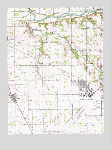
Onward, IN USGS Topographic Map
Click on map above to begin viewing in our Map Viewer.

This topographic map contains these locations and features:
Feature Name Type Latitude Longitude GNIS ID View Map
Bear CreekStreamN40.7409°W86.2300°430629View Map
Bowyer CemeteryCemeteryN40.7280°W86.2192°431415View Map
Cromey DitchCanalN40.7245°W86.2425°433143View Map
Dry Run DitchCanalN40.6792°W86.2281°433733View Map
Garnand CemeteryCemeteryN40.6850°W86.1419°434964View Map
Government DitchCanalN40.6773°W86.1675°435246View Map
Grissom Air Force BaseMilitaryN40.6575°W86.1495°2512229View Map
Grissom Air Force Base Census Designated PlaceCensusN40.6585°W86.1481°2393032View Map
Grissom Air Reserve BaseAirportN40.6622°W86.1496°2677018View Map
Grissom Air Reserve Base Fire DepartmentBuildingN40.6622°W86.1494°2626032View Map
Headland Airport (historical)AirportN40.6403°W86.1897°449375View Map
LewisburgPopulated PlaceN40.7467°W86.2175°437807View Map
Little Deer CreekStreamN40.7253°W86.2186°438039View Map
Little Deer Creek CemeteryCemeteryN40.6948°W86.2096°438041View Map
McNeely ChapelChurchN40.7381°W86.2214°438927View Map
Metzger CemeteryCemeteryN40.7070°W86.1536°439054View Map
Miami Correctional FacilityBuildingN40.6446°W86.1332°2757189View Map
Milner QuarryMineN40.6867°W86.1372°2567528View Map
Naval Air Station Bunker Hill (historical)MilitaryN40.6589°W86.1422°2087781View Map
NeadPopulated PlaceN40.7073°W86.1275°439955View Map
Old Order ChurchChurchN40.7295°W86.1464°440581View Map
OnwardPopulated PlaceN40.6948°W86.1950°440664View Map
Onward Volunteer Fire DepartmentBuildingN40.6940°W86.1950°2626139View Map
Otterbein ChurchChurchN40.6456°W86.2042°440752View Map
Phillips DitchCanalN40.6617°W86.2489°441087View Map
Pipe CreekStreamN40.7456°W86.2208°441184View Map
Pipe Creek ChurchChurchN40.7070°W86.1572°441186View Map
Plothrow PondReservoirN40.7438°W86.1280°452482View Map
Randall Elementary SchoolSchoolN40.6778°W86.1578°441761View Map
Rife CreekStreamN40.7448°W86.1436°442007View Map
Sixby DitchCanalN40.7178°W86.2481°443559View Map
Town of OnwardCivilN40.6946°W86.1952°2396833View Map
Town of WaltonCivilN40.6624°W86.2444°2397720View Map
Township of Pipe CreekCivilN40.6970°W86.1288°453742View Map
Township of TiptonCivilN40.6998°W86.2247°453899View Map
WaltonPopulated PlaceN40.6609°W86.2419°445453View Map
Walton Fire DepartmentBuildingN40.6588°W86.2400°2625796View Map
Walton Post OfficePost OfficeN40.6608°W86.2419°2080650View Map

Note: Coordinates in the location and feature list above are referenced to NAD83 datum.


Copyright (C) 2008-2024 Ryan Niemi / Sunset Dynamics ... All Rights Reserved