TopoQuest Logo
Do you find TopoQuest useful?
Help keep TopoQuest running and adding new maps/features by donating!
Bitcoin:  19c7KJd3qBynnjoSw5npx9KScwjBe4ifkT
Litecoin:  LXs6TkuXGGXo1vDsWCkWVdjQX94eUKd6ui
Home View Maps Find Maps Find Places Resources & Links


Brooks Crossroads, North Carolina Topographic Map

USGS Map Title: Brooks Crossroads, NC
USGS Map MRC: 36080A7
DRG (GeoTIFF) Download: o36080a7.tif


Neighboring USGS Topographic Map Quads:


  Ronda, NC  
36080B8
 

  Elkin South, NC  
36080B7
 

  Yadkinville, NC  
36080B6
 

  Osbornville, NC  
36080A8
 

  Brooks Crossroads, NC  
36080A7
 

  Lone Hickory, NC  
36080A6
 

  Central, NC  
35080H8
 

  Harmony, NC  
35080H7
 

  Calahaln, NC  
35080H6


Map MRC Location:

N37°
W81°
N37°
W80°
H8 H7 H6 H5 H4 H3 H2 H1
G8 G7 G6 G5 G4 G3 G2 G1
F8 F7 F6 F5 F4 F3 F2 F1
E8 E7 E6 E5 E4 E3 E2 E1
D8 D7 D6 D5 D4 D3 D2 D1
C8 C7 C6 C5 C4 C3 C2 C1
B8 B7 B6 B5 B4 B3 B2 B1
A8 A7 A6 A5 A4 A3 A2 A1
N36°
W81°
N36°
W80°

Brooks Crossroads, NC USGS 1:24K Topographic Map Preview:
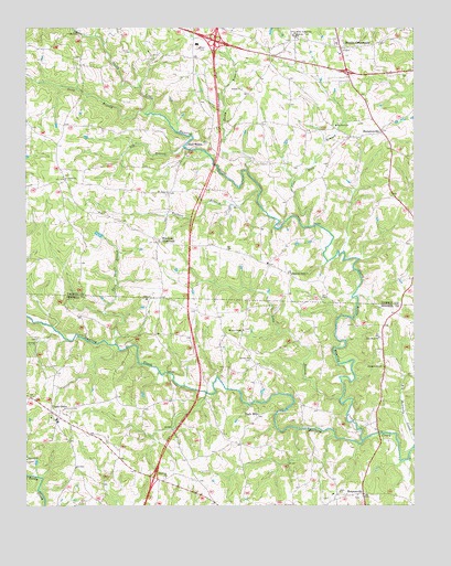
Brooks Crossroads, NC USGS Topographic Map
Click on map above to begin viewing in our Map Viewer.

This topographic map contains these locations and features:
Feature Name Type Latitude Longitude GNIS ID View Map
Asbury CemeteryCemeteryN36.1096°W80.8056°1731710View Map
Asbury United Methodist ChurchChurchN36.1093°W80.8051°980304View Map
Beulah ChurchChurchN36.0387°W80.8028°981756View Map
Big BranchStreamN36.0943°W80.8242°981350View Map
Brooks CrossroadsPopulated PlaceN36.1201°W80.7731°981978View Map
Buck Shoal Township (historical)CivilN36.1154°W80.8090°1027353View Map
Buck ShoalsLocaleN36.0940°W80.8215°982116View Map
Buck Shoals BranchStreamN36.0426°W80.8462°982117View Map
Buck Shoals Volunteer Fire DepartmentBuildingN36.0886°W80.8637°2638114View Map
Calvary ChurchChurchN36.0124°W80.8742°982457View Map
Dobbins CreekStreamN36.1229°W80.8523°984235View Map
Eagle MillsPopulated PlaceN36.0237°W80.8001°1006188View Map
Fairview School (historical)SchoolN36.0632°W80.7965°1731814View Map
Flat Rock Baptist ChurchChurchN36.0999°W80.7748°985181View Map
Flat Rock BranchStreamN36.0732°W80.7840°985176View Map
Flat Rock CemeteryCemeteryN36.1007°W80.7740°1731735View Map
HamptonvillePopulated PlaceN36.0985°W80.7603°986345View Map
Hamptonville AirportAirportN36.0901°W80.7890°2787156View Map
Hamptonville Post OfficePost OfficeN36.1183°W80.7953°2774344View Map
HoustonvillePopulated PlaceN36.0032°W80.7662°1006247View Map
Hunting Creek CemeteryCemeteryN36.0604°W80.7890°1731750View Map
Hunting Creek Friends ChurchChurchN36.0607°W80.7892°987266View Map
Long BranchStreamN36.0282°W80.7737°988912View Map
Long BranchStreamN36.1026°W80.8362°988928View Map
Mayberry Mill (historical)LocaleN36.1240°W80.8581°1731825View Map
New Hope ChurchChurchN36.0440°W80.7609°991017View Map
North Little Hunting CreekStreamN36.0171°W80.7665°1021670View Map
Parks LakeReservoirN36.0711°W80.8514°1000017View Map
Parks Lake DamDamN36.0701°W80.8498°1000018View Map
Pleasant Hill ChurchChurchN36.0365°W80.7595°992538View Map
Rocky BranchStreamN36.0879°W80.8037°993572View Map
Saint Paul CemeteryCemeteryN36.0815°W80.8298°1731780View Map
Saint Paul Methodist ChurchChurchN36.0818°W80.8290°994096View Map
Shiloh Baptist ChurchChurchN36.0857°W80.8620°994707View Map
Shiloh CemeteryCemeteryN36.0860°W80.8623°1731784View Map
Sloans Mill (historical)LocaleN36.0737°W80.7928°1731833View Map
Township of Eagle MillsCivilN36.0077°W80.7508°1026819View Map
Township of South Buck ShoalsCivilN36.0759°W80.8161°2405113View Map
Township of Union GroveCivilN36.0120°W80.8553°1026827View Map
Union GrovePopulated PlaceN36.0246°W80.8662°996473View Map
Union Grove CemeteryCemeteryN36.0226°W80.8670°1731706View Map
Union Grove Post OfficePost OfficeN36.0238°W80.8637°2774372View Map
Union Grove SchoolSchoolN36.0221°W80.8642°1001751View Map
Union Grove United Methodist ChurchChurchN36.0232°W80.8667°1805896View Map
Union Grove Volunteer Fire DepartmentBuildingN36.0221°W80.8626°2638074View Map
Walkers BranchStreamN36.0824°W80.7990°996703View Map
Wesley Chapel Methodist ChurchChurchN36.0462°W80.8051°996968View Map
West Yadkin SchoolSchoolN36.1235°W80.7878°997052View Map
West Yadkin Volunteer Fire DepartmentBuildingN36.1227°W80.7747°2638112View Map
Windsors CrossroadsPopulated PlaceN36.0696°W80.8317°1006410View Map
Winthrop ChurchChurchN36.0076°W80.8295°997504View Map
Yoder Dairy FarmLocaleN36.0603°W80.8250°2680748View Map
Zion Baptist ChurchChurchN36.0540°W80.8359°1805897View Map
Zion CemeteryCemeteryN36.0537°W80.8365°1731707View Map

Note: Coordinates in the location and feature list above are referenced to NAD83 datum.


Copyright (C) 2008-2024 Ryan Niemi / Sunset Dynamics ... All Rights Reserved