TopoQuest Logo
Do you find TopoQuest useful?
Help keep TopoQuest running and adding new maps/features by donating!
Bitcoin:  19c7KJd3qBynnjoSw5npx9KScwjBe4ifkT
Litecoin:  LXs6TkuXGGXo1vDsWCkWVdjQX94eUKd6ui
Home View Maps Find Maps Find Places Resources & Links


Lone Star, South Carolina Topographic Map

USGS Map Title: Lone Star, SC
USGS Map MRC: 33080F5
DRG (GeoTIFF) Download: o33080f5.tif


Neighboring USGS Topographic Map Quads:


  Wateree, SC  
33080G6
 

  Poinsett State Park, SC  
33080G5
 

  Privateer, SC  
33080G4
 

  Fort Motte, SC  
33080F6
 

  Lone Star, SC  
33080F5
 

  Pinewood, SC  
33080F4
 

  Cameron, SC  
33080E6
 

  Elloree, SC  
33080E5
 

  Saint Paul, SC  
33080E4


Map MRC Location:

N34°
W81°
N34°
W80°
H8 H7 H6 H5 H4 H3 H2 H1
G8 G7 G6 G5 G4 G3 G2 G1
F8 F7 F6 F5 F4 F3 F2 F1
E8 E7 E6 E5 E4 E3 E2 E1
D8 D7 D6 D5 D4 D3 D2 D1
C8 C7 C6 C5 C4 C3 C2 C1
B8 B7 B6 B5 B4 B3 B2 B1
A8 A7 A6 A5 A4 A3 A2 A1
N33°
W81°
N33°
W80°

Lone Star, SC USGS 1:24K Topographic Map Preview:
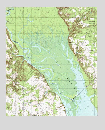
Lone Star, SC USGS Topographic Map
Click on map above to begin viewing in our Map Viewer.

This topographic map contains these locations and features:
Feature Name Type Latitude Longitude GNIS ID View Map
Antioch ChurchChurchN33.6829°W80.5062°1244897View Map
Broughton Millpond (historical)LakeN33.7238°W80.5334°1220999View Map
Congaree RiverStreamN33.7440°W80.6193°1249468View Map
Culp PondReservoirN33.7034°W80.5274°1239384View Map
Culp Pond Dam D-2077DamN33.7027°W80.5277°1239383View Map
Elliots LandingLocaleN33.6427°W80.5095°1235968View Map
Fairy School (historical)SchoolN33.6704°W80.5015°1244516View Map
Fort Motte Fire Department Lone Star StationBuildingN33.6496°W80.6033°2578377View Map
Fulton CrossroadsPopulated PlaceN33.7279°W80.5104°1247849View Map
Fulton SchoolSchoolN33.7329°W80.5231°1222608View Map
Gadden PondReservoirN33.7038°W80.6181°1239594View Map
Gadden Pond Dam D-2656DamN33.7052°W80.6181°1239593View Map
Haynes ChapelChurchN33.6277°W80.5893°1223099View Map
Lone StarPopulated PlaceN33.6254°W80.5895°1224106View Map
Low Falls LandingLocaleN33.6321°W80.5434°1234704View Map
Mac Boykin YMCA CampLocaleN33.7432°W80.5098°1244590View Map
MilfordPopulated PlaceN33.7471°W80.5331°1246654View Map
Mill CreekStreamN33.7207°W80.5379°1224532View Map
Mill Creek Park PondReservoirN33.7365°W80.5222°1239382View Map
Mill Creek Pond Park Dam D-2066DamN33.7352°W80.5248°1239381View Map
New Zion ChurchChurchN33.7407°W80.5287°1225031View Map
Old Zion ChurchChurchN33.7365°W80.5284°1225220View Map
Pine Grove ChurchChurchN33.6352°W80.6015°1225438View Map
Pine Grove SchoolSchoolN33.6410°W80.6151°1225449View Map
Poinsett State ForestForestN33.7329°W80.5059°1225574View Map
RiminiPopulated PlaceN33.6693°W80.5004°1250390View Map
Saint Mark ChurchChurchN33.6554°W80.6004°1226183View Map
Saint Marks ChurchChurchN33.7474°W80.5104°1250592View Map
Santee Cooper ReservationReserveN33.6749°W80.5356°1226396View Map
Spring Grove CreekStreamN33.6468°W80.5101°1250999View Map
Squirrel CreekStreamN33.6952°W80.6076°1251021View Map
Tavern CreekStreamN33.7393°W80.5765°1227043View Map
Touchberry Lower PondReservoirN33.6904°W80.5254°1239386View Map
Touchberry Lower Pond Dam D-1586DamN33.6918°W80.5281°1239385View Map
Warley CreekStreamN33.6896°W80.6001°1251325View Map
Wateree RiverStreamN33.7440°W80.6193°1249440View Map
Way PondReservoirN33.6974°W80.6147°1239651View Map
Way Pond Dam D-2657DamN33.6963°W80.6137°1239650View Map
Weeks LandingPopulated PlaceN33.6902°W80.5998°1231900View Map

Note: Coordinates in the location and feature list above are referenced to NAD83 datum.


Copyright (C) 2008-2024 Ryan Niemi / Sunset Dynamics ... All Rights Reserved