TopoQuest Logo
Do you find TopoQuest useful?
Help keep TopoQuest running and adding new maps/features by donating!
Bitcoin:  19c7KJd3qBynnjoSw5npx9KScwjBe4ifkT
Litecoin:  LXs6TkuXGGXo1vDsWCkWVdjQX94eUKd6ui
Home View Maps Find Maps Find Places Resources & Links


Long Mountain, Colorado Topographic Map

USGS Map Title: Long Mountain, CO
USGS Map MRC: 37107A8
DRG (GeoTIFF) Download: o37107a8.tif


Neighboring USGS Topographic Map Quads:


  Kline, CO  
37108B1
 

  Basin Mountain, CO  
37107B8
 

  Loma Linda, CO  
37107B7
 

  Pinkerton Mesa, CO  
37108A1
 

  Long Mountain, CO  
37107A8
 

  Bondad Hill, CO  
37107A7
 

  Adobe Downs Ranch, NM  
36108H1
 

  Cedar Hill, NM  
36107H8
 

  Mount Nebo, NM  
36107H7


Map MRC Location:

N38°
W108°
N38°
W107°
H8 H7 H6 H5 H4 H3 H2 H1
G8 G7 G6 G5 G4 G3 G2 G1
F8 F7 F6 F5 F4 F3 F2 F1
E8 E7 E6 E5 E4 E3 E2 E1
D8 D7 D6 D5 D4 D3 D2 D1
C8 C7 C6 C5 C4 C3 C2 C1
B8 B7 B6 B5 B4 B3 B2 B1
A8 A7 A6 A5 A4 A3 A2 A1
N37°
W108°
N37°
W107°

Long Mountain, CO USGS 1:24K Topographic Map Preview:
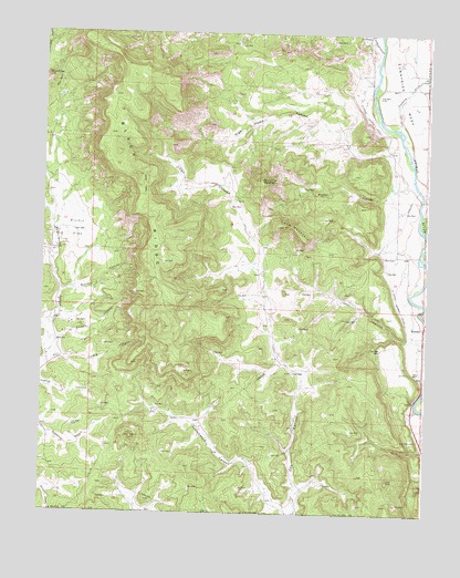
Long Mountain, CO USGS Topographic Map
Click on map above to begin viewing in our Map Viewer.

This topographic map contains these locations and features:
Feature Name Type Latitude Longitude GNIS ID View Map
Big FlatFlatN37.0500°W107.9895°184452View Map
Black RidgeRidgeN37.0778°W107.9662°202652View Map
BondadPopulated PlaceN37.0458°W107.8762°203010View Map
Citizens Animas DitchCanalN37.0917°W107.8870°203013View Map
Cottonwood CanyonValleyN37.0015°W107.9177°184449View Map
Deer CanyonValleyN37.0447°W107.8812°184448View Map
Elco CemeteryCemeteryN37.0673°W107.8895°184458View Map
High Flume CanyonValleyN37.0948°W107.8884°184460View Map
La Posta CanyonValleyN37.1202°W107.8913°179293View Map
La Posta CemeteryCemeteryN37.1230°W107.8951°2780651View Map
Long CanyonValleyN37.0403°W107.9944°184450View Map
Long MountainSummitN37.0744°W107.9242°184454View Map
Mitchell CanyonValleyN37.0571°W107.9937°184453View Map
Picnic FlatFlatN37.0736°W107.9895°184455View Map
Picnic Flat SchoolSchoolN37.0683°W107.9976°184459View Map
Poison CanyonValleyN37.0445°W107.9946°184451View Map
Round TopSummitN37.1131°W107.9992°184461View Map
Round Top MountainSummitN37.0869°W107.9298°184457View Map
Trumble DrawValleyN37.1017°W107.8848°184386View Map
Twin CrossingLocaleN37.0297°W107.8784°203011View Map
Walter CanyonValleyN37.0822°W107.8890°184456View Map

Note: Coordinates in the location and feature list above are referenced to NAD83 datum.


Copyright (C) 2008-2025 Ryan Niemi / Sunset Dynamics ... All Rights Reserved