TopoQuest Logo
Do you find TopoQuest useful?
Help keep TopoQuest running and adding new maps/features by donating!
Bitcoin:  19c7KJd3qBynnjoSw5npx9KScwjBe4ifkT
Litecoin:  LXs6TkuXGGXo1vDsWCkWVdjQX94eUKd6ui
Home View Maps Find Maps Find Places Resources & Links


Casar, North Carolina Topographic Map

USGS Map Title: Casar, NC
USGS Map MRC: 35081E5
DRG (GeoTIFF) Download: o35081e5.tif


Neighboring USGS Topographic Map Quads:


  Morganton South, NC  
35081F6
 

  Valdese, NC  
35081F5
 

  Longview, NC  
35081F4
 

  Benn Knob, NC  
35081E6
 

  Casar, NC  
35081E5
 

  Banoak, NC  
35081E4
 

  Polkville, NC  
35081D6
 

  Lawndale, NC  
35081D5
 

  Cherryville, NC  
35081D4


Map MRC Location:

N36°
W82°
N36°
W81°
H8 H7 H6 H5 H4 H3 H2 H1
G8 G7 G6 G5 G4 G3 G2 G1
F8 F7 F6 F5 F4 F3 F2 F1
E8 E7 E6 E5 E4 E3 E2 E1
D8 D7 D6 D5 D4 D3 D2 D1
C8 C7 C6 C5 C4 C3 C2 C1
B8 B7 B6 B5 B4 B3 B2 B1
A8 A7 A6 A5 A4 A3 A2 A1
N35°
W82°
N35°
W81°

Casar, NC USGS 1:24K Topographic Map Preview:
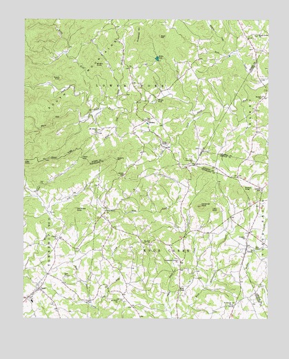
Casar, NC USGS Topographic Map
Click on map above to begin viewing in our Map Viewer.

This topographic map contains these locations and features:
Feature Name Type Latitude Longitude GNIS ID View Map
Bald Knob CreekStreamN35.5040°W81.5862°980472View Map
Beulah ChurchChurchN35.5926°W81.5031°981270View Map
Big Hill ChurchChurchN35.5310°W81.5615°981403View Map
Brushy KnobSummitN35.6062°W81.5884°1019333View Map
Buffalo KnobSummitN35.5543°W81.5120°1019391View Map
Camp CreekPopulated PlaceN35.5746°W81.5534°1019487View Map
Camp CreekStreamN35.5840°W81.5276°982518View Map
Carpenter KnobSummitN35.5474°W81.5345°982670View Map
Carpenters Grove ChurchChurchN35.5246°W81.5456°982671View Map
CasarPopulated PlaceN35.5124°W81.6173°982716View Map
Casar Elementary SchoolSchoolN35.5074°W81.6204°1001454View Map
Casar Post OfficePost OfficeN35.5131°W81.6164°2774088View Map
Casar Volunteer Fire DepartmentBuildingN35.5117°W81.6185°2638978View Map
Doublehead MountainSummitN35.6190°W81.5662°1020014View Map
Ellis ChapelChurchN35.5296°W81.5073°984733View Map
Gilead RidgeRidgeN35.5682°W81.6051°985685View Map
High RockSummitN35.5665°W81.6243°1020755View Map
Knob CreekPopulated PlaceN35.5126°W81.5451°1021062View Map
Knob Creek Township 10 (historical)CivilN35.5176°W81.5562°1026569View Map
Laurel HillPopulated PlaceN35.5546°W81.5029°1021106View Map
Leman GapGapN35.5604°W81.5734°988345View Map
Little KnobSummitN35.5457°W81.5256°1021204View Map
Little RiverStreamN35.5954°W81.5918°988750View Map
Maple Grove ChurchChurchN35.6190°W81.5051°989304View Map
Mount Gilead ChurchChurchN35.5782°W81.5876°1000763View Map
Mull Grove (historical)LocaleN35.5921°W81.5576°1001481View Map
Noah MountainSummitN35.6182°W81.5559°1021653View Map
Old Sheep KnobSummitN35.5454°W81.5984°1021737View Map
Olive GrovePopulated PlaceN35.5432°W81.5837°1001484View Map
Olive Grove ChurchChurchN35.5451°W81.5834°991638View Map
Peoples ChurchChurchN35.5337°W81.5118°992043View Map
Pine Mountain LakesPopulated PlaceN35.5835°W81.5940°1005955View Map
Pisgah ChurchChurchN35.5337°W81.6073°992414View Map
Poundingmill CreekStreamN35.5137°W81.5315°992761View Map
Queens CreekStreamN35.5876°W81.5737°992948View Map
Queens MountainSummitN35.5668°W81.5784°1022125View Map
RamseyPopulated PlaceN35.5829°W81.5623°993014View Map
Saint Pauls ChurchChurchN35.5079°W81.5762°994085View Map
Saint Peters ChurchChurchN35.5060°W81.5179°994117View Map
Seeley CreekStreamN35.5882°W81.5762°994485View Map
Shoups FordPopulated PlaceN35.5918°W81.5598°1022619View Map
South Mountains Volunteer Fire DepartmentBuildingN35.5829°W81.5628°2639102View Map
Swenk KnobSummitN35.6007°W81.6065°1022869View Map
Tim CreekStreamN35.5435°W81.6120°996109View Map
TolucaPopulated PlaceN35.5293°W81.5109°996132View Map
Town of CasarCivilN35.5127°W81.6168°2406233View Map
Township of Lower ForkCivilN35.6179°W81.5806°1026463View Map
Ward GapGapN35.5674°W81.5951°996778View Map
White Oak CreekStreamN35.5885°W81.5823°997173View Map
Whitener CreekStreamN35.6112°W81.5226°997234View Map
Willis LakeReservoirN35.6088°W81.5569°997412View Map
Willis Lake DamDamN35.6085°W81.5565°999152View Map
Zion Hill ChurchChurchN35.5649°W81.5390°997800View Map
Zoar ChurchChurchN35.5176°W81.6023°997812View Map

Note: Coordinates in the location and feature list above are referenced to NAD83 datum.


Copyright (C) 2008-2024 Ryan Niemi / Sunset Dynamics ... All Rights Reserved