TopoQuest Logo
Do you find TopoQuest useful?
Help keep TopoQuest running and adding new maps/features by donating!
Bitcoin:  19c7KJd3qBynnjoSw5npx9KScwjBe4ifkT
Litecoin:  LXs6TkuXGGXo1vDsWCkWVdjQX94eUKd6ui
Home View Maps Find Maps Find Places Resources & Links


Lonoke, Arkansas Topographic Map

USGS Map Title: Lonoke, AR
USGS Map MRC: 34091G8
DRG (GeoTIFF) Download: o34091g8.tif


Neighboring USGS Topographic Map Quads:


  Cabot, AR  
34092H1
 

  Oak Grove, AR  
34091H8
 

  Wattensaw, AR  
34091H7
 

  Jacksonville, AR  
34092G1
 

  Lonoke, AR  
34091G8
 

  Pocket Prairie, AR  
34091G7
 

  Scott, AR  
34092F1
 

  Pettus, AR  
34091F8
 

  Culler, AR  
34091F7


Map MRC Location:

N35°
W92°
N35°
W91°
H8 H7 H6 H5 H4 H3 H2 H1
G8 G7 G6 G5 G4 G3 G2 G1
F8 F7 F6 F5 F4 F3 F2 F1
E8 E7 E6 E5 E4 E3 E2 E1
D8 D7 D6 D5 D4 D3 D2 D1
C8 C7 C6 C5 C4 C3 C2 C1
B8 B7 B6 B5 B4 B3 B2 B1
A8 A7 A6 A5 A4 A3 A2 A1
N34°
W92°
N34°
W91°

Lonoke, AR USGS 1:24K Topographic Map Preview:
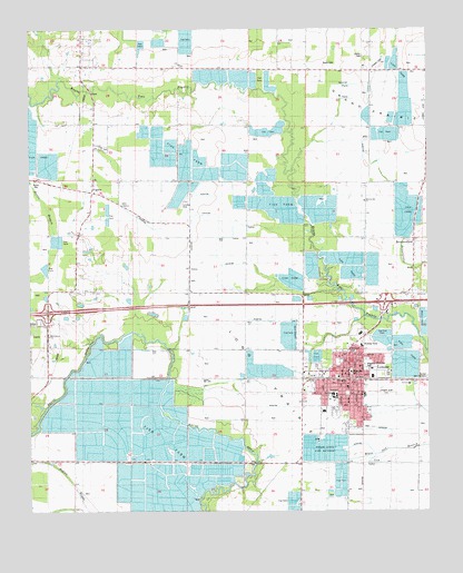
Lonoke, AR USGS Topographic Map
Click on map above to begin viewing in our Map Viewer.

This topographic map contains these locations and features:
Feature Name Type Latitude Longitude GNIS ID View Map
Beard CemeteryCemeteryN34.8665°W91.9079°46247View Map
Bell Grove ChurchChurchN34.7956°W91.9940°59104View Map
Bethel African Methodist Episcopal ChurchChurchN34.7798°W91.8965°66363View Map
Brewer School (historical)SchoolN34.8729°W91.9893°61340View Map
BrownsvillePopulated PlaceN34.8195°W91.8793°59092View Map
Brownsville CemeteryCemeteryN34.8159°W91.8790°47028View Map
Brownsville ChurchChurchN34.8306°W91.8951°47029View Map
Brownsville SchoolSchoolN34.8195°W91.8793°47030View Map
Bully Henry AirportAirportN34.8661°W91.9778°2650739View Map
Burris CemeteryCemeteryN34.8362°W91.9985°76410View Map
Church of ChristChurchN34.7740°W91.8962°66364View Map
City of LonokeCivilN34.7907°W91.9073°2404954View Map
Concord ChurchChurchN34.8445°W91.9771°47954View Map
Country Air Estates AirportAirportN34.8152°W91.9954°2650731View Map
Eastside Baptist ChurchChurchN34.7862°W91.8968°66365View Map
Eberts Field (historical)MilitaryN34.7953°W91.9164°2107186View Map
Fairview SchoolSchoolN34.8643°W91.8926°48979View Map
First Assembly of God ChurchChurchN34.7884°W91.8965°66366View Map
First Presbyterian ChurchChurchN34.7818°W91.9004°66367View Map
First United Methodist ChurchChurchN34.7823°W91.9004°66368View Map
First United Pentecostal ChurchChurchN34.7873°W91.8801°66369View Map
FurlowPopulated PlaceN34.8331°W91.9804°57781View Map
Furlow School (historical)SchoolN34.8401°W91.9796°61339View Map
Goacher Airport (historical)AirportN34.8293°W91.9543°83757View Map
Hester CemeteryCemeteryN34.8679°W91.8951°50035View Map
Hogan State Fish HatcheryLocaleN34.7662°W91.9082°78869View Map
Interchange 169CrossingN34.8018°W91.9946°59019View Map
Interchange 175CrossingN34.8040°W91.8887°59020View Map
Jerusalem Church of God and ChristChurchN34.7734°W91.8957°66370View Map
Ketchum ParkParkN34.7912°W91.9004°59106View Map
Kingdom Hall of Jehovahs WitnessesChurchN34.7898°W91.9032°66371View Map
KMZX-FM (Lonoke)TowerN34.7751°W91.8926°85217View Map
LonokePopulated PlaceN34.7840°W91.8999°77553View Map
Lonoke Baptist ChurchChurchN34.7845°W91.9035°66372View Map
Lonoke CemeteryCemeteryN34.7879°W91.9137°61349View Map
Lonoke City HallBuildingN34.7837°W91.9015°61346View Map
Lonoke City ParkParkN34.7804°W91.9007°61345View Map
Lonoke CountyCivilN34.7543°W91.8887°69164View Map
Lonoke County CourthouseBuildingN34.7859°W91.8996°61350View Map
Lonoke County Sheriff's OfficeBuildingN34.8101°W91.8882°2118684View Map
Lonoke Elementary SchoolSchoolN34.7780°W91.9103°61344View Map
Lonoke High SchoolSchoolN34.7806°W91.9042°61343View Map
Lonoke Junior High SchoolSchoolN34.7798°W91.8951°61347View Map
Lonoke Middle SchoolSchoolN34.7781°W91.9138°2039192View Map
Lonoke Nursing HomeBuildingN34.7812°W91.8946°61348View Map
Lonoke Police DepartmentBuildingN34.7836°W91.9014°2118683View Map
Lonoke Post OfficePost OfficeN34.7854°W91.8985°84026View Map
Lonoke Primary SchoolSchoolN34.7760°W91.9080°61342View Map
Lonoke Volunteer Fire StationBuildingN34.7836°W91.8980°2116741View Map
MetoPopulated PlaceN34.7856°W91.9960°57115View Map
Metropolitan Emergency Medical Service - LonokeBuildingN34.7913°W91.9006°2119094View Map
New Testament Baptist ChurchChurchN34.7804°W91.9110°66373View Map
Oak Tree Plaza Shopping CenterLocaleN34.7959°W91.8962°61352View Map
Prairie Grove School (historical)SchoolN34.8326°W91.9501°61341View Map
Rainbow Shopping CenterLocaleN34.7918°W91.8960°61351View Map
Robinson SchoolSchoolN34.7998°W91.9949°54079View Map
Saint James United Methodist ChurchChurchN34.7743°W91.8932°66374View Map
Saint Johns Baptist ChurchChurchN34.7768°W91.8943°66375View Map
South Bend Fire Department Station 2BuildingN34.8270°W91.9810°2117135View Map
South Bend Fire Department Station 3BuildingN34.8666°W91.9791°2117136View Map
Township of FurlowCivilN34.8327°W91.9760°68818View Map
Township of LonokeCivilN34.7829°W91.8887°68826View Map
Two Prairie BayouStreamN34.7909°W91.8754°55764View Map
Union SchoolSchoolN34.8304°W91.9807°55828View Map
Waggoner Memorial ParkParkN34.7876°W91.8951°59105View Map

Note: Coordinates in the location and feature list above are referenced to NAD83 datum.


Copyright (C) 2008-2025 Ryan Niemi / Sunset Dynamics ... All Rights Reserved