TopoQuest Logo
Do you find TopoQuest useful?
Help keep TopoQuest running and adding new maps/features by donating!
Bitcoin:  19c7KJd3qBynnjoSw5npx9KScwjBe4ifkT
Litecoin:  LXs6TkuXGGXo1vDsWCkWVdjQX94eUKd6ui
Home View Maps Find Maps Find Places Resources & Links


Coldwater, Mississippi Topographic Map

USGS Map Title: Coldwater, MS
USGS Map MRC: 34089F8
DRG (GeoTIFF) Download: o34089f8.tif


Neighboring USGS Topographic Map Quads:


  Frees Corners, MS  
34090G1
 

  Hernando, MS  
34089G8
 

  Lewisburg, MS  
34089G7
 

  Arkabutla East, MS  
34090F1
 

  Coldwater, MS  
34089F8
 

  Independence, MS  
34089F7
 

  Longtown, MS  
34090E1
 

  Senatobia, MS  
34089E8
 

  Looxahoma, MS  
34089E7


Map MRC Location:

N35°
W90°
N35°
W89°
H8 H7 H6 H5 H4 H3 H2 H1
G8 G7 G6 G5 G4 G3 G2 G1
F8 F7 F6 F5 F4 F3 F2 F1
E8 E7 E6 E5 E4 E3 E2 E1
D8 D7 D6 D5 D4 D3 D2 D1
C8 C7 C6 C5 C4 C3 C2 C1
B8 B7 B6 B5 B4 B3 B2 B1
A8 A7 A6 A5 A4 A3 A2 A1
N34°
W90°
N34°
W89°

Coldwater, MS USGS 1:24K Topographic Map Preview:
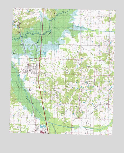
Coldwater, MS USGS Topographic Map
Click on map above to begin viewing in our Map Viewer.

This topographic map contains these locations and features:
Feature Name Type Latitude Longitude GNIS ID View Map
Basket CreekStreamN34.6323°W89.9076°666559View Map
Beartail CreekStreamN34.7284°W89.9526°666670View Map
Bethel CemeteryCemeteryN34.6632°W89.9420°666892View Map
Bethel ChurchChurchN34.6634°W89.9418°666958View Map
Billys CreekStreamN34.6337°W89.9379°683400View Map
Buckner Landing (historical)LocaleN34.6667°W89.9167°2548750View Map
Buena Vista Lake DamDamN34.7318°W89.9951°690421View Map
Buntin CemeteryCemeteryN34.6673°W89.9443°683403View Map
Calvary ChurchChurchN34.6790°W89.9773°683404View Map
Central Avenue Church of ChristChurchN34.6884°W89.9829°683405View Map
Central Tate Elementary School (historical)SchoolN34.6909°W89.9712°705991View Map
ColdwaterPopulated PlaceN34.6918°W89.9773°668665View Map
Coldwater Airport (historical)AirportN34.6834°W89.9834°680435View Map
Coldwater Attendance CenterSchoolN34.6882°W89.9854°705994View Map
Coldwater CemeteryCemeteryN34.6988°W89.9559°668666View Map
Coldwater Church of ChristChurchN34.6937°W89.9798°705992View Map
Coldwater Elementary SchoolSchoolN34.6854°W89.9720°705993View Map
Coldwater Lagoon DamDamN34.6918°W89.9784°682779View Map
Coldwater Point Public Use AreaParkN34.7048°W89.9987°683409View Map
Coldwater Police DepartmentBuildingN34.6890°W89.9762°2754089View Map
Coldwater Post OfficePost OfficeN34.6884°W89.9762°2768832View Map
Coldwater United Methodist ChurchChurchN34.6901°W89.9723°683410View Map
Cromecraft LakeReservoirN34.6319°W89.9615°683413View Map
Daniels CemeteryCemeteryN34.7434°W89.8795°669098View Map
Daniels ChapelChurchN34.7432°W89.8809°669100View Map
David E Jones Pond DamDamN34.6701°W89.9584°682769View Map
Deans CemeteryCemeteryN34.6568°W89.8809°669179View Map
Deer Track LakeReservoirN34.7316°W89.9964°690487View Map
Dowdy ChurchChurchN34.6457°W89.9331°669368View Map
Dowdy SchoolSchoolN34.6457°W89.9331°669369View Map
East Antioch ChurchChurchN34.6454°W89.9337°683415View Map
Edwards Chapel CemeteryCemeteryN34.6843°W89.9593°669687View Map
Edwin Scott Pond DamDamN34.6668°W89.9068°682765View Map
Elm Grove (historical)LocaleN34.7029°W89.9709°683421View Map
Everson CemeteryCemeteryN34.6765°W89.9113°669769View Map
Faith ChapelChurchN34.6562°W89.8806°683424View Map
First Baptist Church of ColdwaterChurchN34.6876°W89.9723°705997View Map
Hickory Grove CemeteryCemeteryN34.6484°W89.8873°671160View Map
Hickory Grove ChurchChurchN34.6484°W89.8890°671169View Map
Hickory Grove SchoolSchoolN34.6484°W89.8890°671171View Map
Highway Fiftyone LandingLocaleN34.7251°W89.9906°690522View Map
Interchange 271CrossingN34.6995°W89.9648°691460View Map
Jackson (historical)LocaleN34.7084°W89.8779°683432View Map
Lake LarueReservoirN34.7471°W89.9815°690537View Map
Lashures CemeteryCemeteryN34.6920°W89.8917°672311View Map
Lashures SchoolSchoolN34.6918°W89.8937°672312View Map
LeSure CemeteryCemeteryN34.6923°W89.8945°683437View Map
Liberty ChurchChurchN34.6998°W89.9193°672458View Map
Magnolia CemeteryCemeteryN34.6987°W89.9573°683444View Map
Methodist CemeteryCemeteryN34.6848°W89.9617°673507View Map
Mrs T P Wilson Pond DamDamN34.6268°W89.9901°682745View Map
New Garden CemeteryCemeteryN34.7434°W89.9004°674628View Map
New Garden ChurchChurchN34.7432°W89.9004°674631View Map
New Garden SchoolSchoolN34.7434°W89.9001°674632View Map
Northwest Mississippi Community CollegeSchoolN34.6256°W89.9697°674978View Map
Old Love CemeteryCemeteryN34.7456°W89.9765°690566View Map
Palestine (historical)LocaleN34.7434°W89.8831°683459View Map
Palestine CemeteryCemeteryN34.7429°W89.8851°675392View Map
Palestine ChurchChurchN34.7440°W89.8854°675408View Map
Perry CemeteryCemeteryN34.7334°W89.9884°690374View Map
Pritchard CemeteryCemeteryN34.7028°W89.9353°683461View Map
Scotland CemeteryCemeteryN34.7148°W89.8942°677463View Map
Scotland ChurchChurchN34.7159°W89.8851°677466View Map
Second Baptist ChurchChurchN34.6893°W89.9706°683469View Map
Senatobia CreekStreamN34.6362°W89.9498°677514View Map
Senatobia Lakes Incorporated Pond DamDamN34.6268°W89.8784°682744View Map
Skybrand LakeReservoirN34.7295°W89.9922°690591View Map
Steammill BranchStreamN34.6459°W89.9040°683475View Map
Strickland CemeteryCemeteryN34.6929°W89.9076°683476View Map
Suent LakeReservoirN34.6671°W89.9586°683477View Map
Supervisor District 3CivilN34.7123°W89.9278°712092View Map
Tate CountyCivilN34.6503°W89.9448°695789View Map
Thornton CreekStreamN34.6329°W89.9123°678731View Map
Town of ColdwaterCivilN34.6902°W89.9757°2406292View Map
Wilco EstatesPopulated PlaceN34.7487°W89.9820°690604View Map

Note: Coordinates in the location and feature list above are referenced to NAD83 datum.


Copyright (C) 2008-2024 Ryan Niemi / Sunset Dynamics ... All Rights Reserved