TopoQuest Logo
Do you find TopoQuest useful?
Help keep TopoQuest running and adding new maps/features by donating!
Bitcoin:  19c7KJd3qBynnjoSw5npx9KScwjBe4ifkT
Litecoin:  LXs6TkuXGGXo1vDsWCkWVdjQX94eUKd6ui
Home View Maps Find Maps Find Places Resources & Links


Lowell, Georgia Topographic Map

USGS Map Title: Lowell, GA
USGS Map MRC: 33085D1
DRG (GeoTIFF) Download: o33085d1.tif


Neighboring USGS Topographic Map Quads:


  Bowdon East, GA  
33085E2
 

  Carrollton, GA  
33085E1
 

  Hulett, GA  
33084E8
 

  Roopville, GA  
33085D2
 

  Lowell, GA  
33085D1
 

  Whitesburg, GA  
33084D8
 

  Frolona, GA  
33085C2
 

  Franklin, GA  
33085C1
 

  Newnan SW, GA  
33084C8


Map MRC Location:

N34°
W86°
N34°
W85°
H8 H7 H6 H5 H4 H3 H2 H1
G8 G7 G6 G5 G4 G3 G2 G1
F8 F7 F6 F5 F4 F3 F2 F1
E8 E7 E6 E5 E4 E3 E2 E1
D8 D7 D6 D5 D4 D3 D2 D1
C8 C7 C6 C5 C4 C3 C2 C1
B8 B7 B6 B5 B4 B3 B2 B1
A8 A7 A6 A5 A4 A3 A2 A1
N33°
W86°
N33°
W85°

Lowell, GA USGS 1:24K Topographic Map Preview:
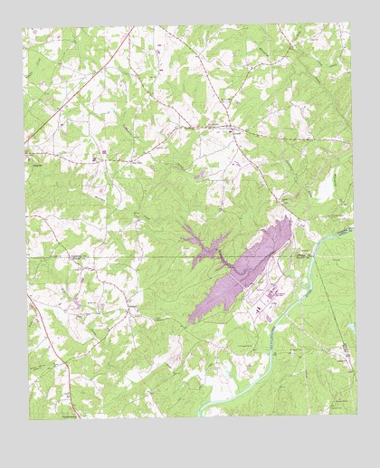
Lowell, GA USGS Topographic Map
Click on map above to begin viewing in our Map Viewer.

This topographic map contains these locations and features:
Feature Name Type Latitude Longitude GNIS ID View Map
Antioch Missionary Baptist ChurchChurchN33.3921°W85.0036°354352View Map
Bethel Academy (historical)SchoolN33.3918°W85.1155°346999View Map
Bethel Baptist ChurchChurchN33.3921°W85.1155°354611View Map
Bethel CemeteryCemeteryN33.3915°W85.1158°347001View Map
Bowers Ferry (historical)CrossingN33.4309°W85.0122°350079View Map
Caney CreekStreamN33.4896°W85.0186°312308View Map
Carroll County Fire / Rescue Station 12BuildingN33.4653°W85.0359°2604219View Map
Cartbody CreekStreamN33.4815°W85.0127°312364View Map
Cavender CreekStreamN33.4443°W85.0072°312441View Map
Centralhatchee Fire Department Station 4BuildingN33.3819°W85.1082°2604455View Map
Davis CemeteryCemeteryN33.4946°W85.0152°313339View Map
Echols CemeteryCemeteryN33.3904°W85.0538°313846View Map
Friendship CemeteryCemeteryN33.3890°W85.1102°347052View Map
Friendship ChurchChurchN33.4065°W85.0763°314420View Map
Friendship ChurchChurchN33.3890°W85.1099°347053View Map
GlenlochPopulated PlaceN33.4093°W85.0861°356035View Map
Glenloch Baptist ChurchChurchN33.4126°W85.0869°347055View Map
Glenloch CemeteryCemeteryN33.4129°W85.0866°347056View Map
Glenloch School (historical)SchoolN33.4098°W85.0858°347057View Map
Glover LakeReservoirN33.4027°W85.0013°340026View Map
Glover Lake DamDamN33.4034°W85.0016°340025View Map
Goshen CemeteryCemeteryN33.4232°W85.1036°347061View Map
Goshen Congregational Methodist ChurchChurchN33.4232°W85.1033°356063View Map
Hal B Wansley PowerplantBuildingN33.4134°W85.0319°347062View Map
Hardegree CemeteryCemeteryN33.3959°W85.0252°315112View Map
Henley (historical)Populated PlaceN33.4373°W85.0202°349592View Map
Hollingsworth CemeteryCemeteryN33.3976°W85.0388°315546View Map
Johnson Chapel (historical)ChurchN33.4379°W85.0083°349608View Map
Johnson Chapel CemeteryCemeteryN33.4382°W85.0085°316160View Map
Liberty CemeteryCemeteryN33.4432°W85.0263°349621View Map
Liberty ChurchChurchN33.4426°W85.0261°316813View Map
LowellPopulated PlaceN33.4665°W85.0449°317460View Map
Lowell CemeteryCemeteryN33.4659°W85.0472°349625View Map
Lowell Methodist ChurchChurchN33.4668°W85.0466°349626View Map
Milligan CreekStreamN33.4332°W85.0608°318279View Map
Mount Lowell CemeteryCemeteryN33.4679°W85.0544°318681View Map
Mount Lowell ChurchChurchN33.4751°W85.0483°318682View Map
Mount Lowell School (historical)SchoolN33.4676°W85.0549°349652View Map
New Lebanon CemeteryCemeteryN33.4671°W85.0594°349664View Map
New Lebanon ChurchChurchN33.4668°W85.0591°319461View Map
New Yellowdirt CemeteryCemeteryN33.3987°W85.0572°347107View Map
Newnan CemeteryCemeteryN33.3773°W85.0099°319576View Map
Old Frienship CemeteryCemeteryN33.4068°W85.0758°347111View Map
Old Glenloch CemeteryCemeteryN33.4126°W85.0880°347112View Map
Old Yellowdirt CemeteryCemeteryN33.4176°W85.0366°347116View Map
Old Yellowdirt Church (historical)ChurchN33.4173°W85.0369°347117View Map
Pentecost CemeteryCemeteryN33.4609°W85.0749°320368View Map
Pink CreekStreamN33.3787°W85.0586°320745View Map
Pleasant Hill ChurchChurchN33.3790°W85.0086°320892View Map
Pleasant Hill School (historical)SchoolN33.3790°W85.0088°347124View Map
Providence ChurchChurchN33.4271°W85.1158°321200View Map
Roopville DivisionCivilN33.4618°W85.0978°1936510View Map
Simms CemeteryCemeteryN33.3751°W85.0480°323009View Map
Spring View School (historical)SchoolN33.4221°W85.0063°348617View Map
Star PointPopulated PlaceN33.4568°W85.0841°333114View Map
Summerlin-Pullen CemeteryCemeteryN33.4173°W85.0383°347150View Map
Turkey CreekStreamN33.4321°W85.0069°348627View Map
Walker CemeteryCemeteryN33.4118°W85.0980°324771View Map
Watson CemeteryCemeteryN33.4079°W85.0819°347165View Map
Webbs FerryCrossingN33.3946°W85.0324°347166View Map
Yellow Dirt Baptist ChurchChurchN33.3987°W85.0569°347174View Map
YellowdirtPopulated PlaceN33.4140°W85.0408°356655View Map
Yellowdirt CreekStreamN33.4154°W85.0169°325623View Map

Note: Coordinates in the location and feature list above are referenced to NAD83 datum.


Copyright (C) 2008-2024 Ryan Niemi / Sunset Dynamics ... All Rights Reserved