TopoQuest Logo
Do you find TopoQuest useful?
Help keep TopoQuest running and adding new maps/features by donating!
Bitcoin:  19c7KJd3qBynnjoSw5npx9KScwjBe4ifkT
Litecoin:  LXs6TkuXGGXo1vDsWCkWVdjQX94eUKd6ui
Home View Maps Find Maps Find Places Resources & Links


Roopville, Georgia Topographic Map

USGS Map Title: Roopville, GA
USGS Map MRC: 33085D2
DRG (GeoTIFF) Download: o33085d2.tif


Neighboring USGS Topographic Map Quads:


  Bowdon West, GA  
33085E3
 

  Bowdon East, GA  
33085E2
 

  Carrollton, GA  
33085E1
 

  Graham, AL  
33085D3
 

  Roopville, GA  
33085D2
 

  Lowell, GA  
33085D1
 

  Napoleon, AL  
33085C3
 

  Frolona, GA  
33085C2
 

  Franklin, GA  
33085C1


Map MRC Location:

N34°
W86°
N34°
W85°
H8 H7 H6 H5 H4 H3 H2 H1
G8 G7 G6 G5 G4 G3 G2 G1
F8 F7 F6 F5 F4 F3 F2 F1
E8 E7 E6 E5 E4 E3 E2 E1
D8 D7 D6 D5 D4 D3 D2 D1
C8 C7 C6 C5 C4 C3 C2 C1
B8 B7 B6 B5 B4 B3 B2 B1
A8 A7 A6 A5 A4 A3 A2 A1
N33°
W86°
N33°
W85°

Roopville, GA USGS 1:24K Topographic Map Preview:
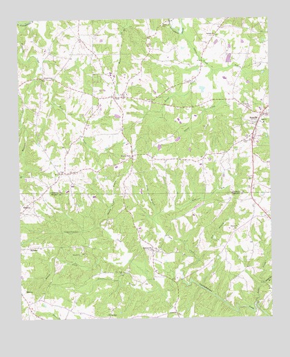
Roopville, GA USGS Topographic Map
Click on map above to begin viewing in our Map Viewer.

This topographic map contains these locations and features:
Feature Name Type Latitude Longitude GNIS ID View Map
Antioch CemeteryCemeteryN33.3768°W85.1727°346997View Map
Antioch ChurchChurchN33.3773°W85.1730°310577View Map
Arnold Chapel (historical)ChurchN33.4348°W85.1916°350059View Map
Becks CreekStreamN33.4748°W85.2416°354522View Map
Bethel Spring BranchStreamN33.3893°W85.1286°311212View Map
Bethesda CemeteryCemeteryN33.4929°W85.1536°350064View Map
Bethesda ChurchChurchN33.4937°W85.1516°354652View Map
Bonner CemeteryCemeteryN33.4940°W85.1272°350070View Map
Bonner MineMineN33.4965°W85.1333°352879View Map
Caney Head CemeteryCemeteryN33.3937°W85.1994°347011View Map
Caney Head United Methodist ChurchChurchN33.3937°W85.1994°354981View Map
Carroll County Fire / Rescue Station 1BuildingN33.4721°W85.2241°2604215View Map
Carroll County Fire / Rescue Station 4BuildingN33.4562°W85.1316°2603981View Map
Centralhatchee DivisionCivilN33.3787°W85.1557°1936169View Map
Crews CemeteryCemeteryN33.3893°W85.1886°347029View Map
Denny BranchStreamN33.4187°W85.1816°313443View Map
Denny CreekStreamN33.3993°W85.1952°313444View Map
Dukes CreekStreamN33.3815°W85.1330°313717View Map
Fairview School (historical)SchoolN33.4854°W85.2111°350139View Map
Gum BranchStreamN33.3990°W85.1616°314954View Map
Gum CreekStreamN33.3954°W85.1702°314963View Map
Gum Creek AirportAirportN33.4212°W85.1619°351887View Map
Hillside CemeteryCemeteryN33.4971°W85.1772°349596View Map
Hillside ChurchChurchN33.4973°W85.1772°356310View Map
Hopewell CemeteryCemeteryN33.4023°W85.2199°347077View Map
Hopewell Primitive Baptist ChurchChurchN33.4021°W85.2202°315655View Map
Indian CreekStreamN33.4934°W85.1683°315889View Map
JoelPopulated PlaceN33.4757°W85.2380°332103View Map
Knopp CreekStreamN33.4784°W85.1530°316503View Map
Laurel Hill CemeteryCemeteryN33.4659°W85.1816°316674View Map
Lizzies BranchStreamN33.3876°W85.1813°317265View Map
Lummie Layton CemeteryCemeteryN33.4118°W85.1911°347085View Map
Mabry (historical)Populated PlaceN33.4746°W85.1633°349629View Map
Mountain CreekStreamN33.4987°W85.2455°319067View Map
Oak Grove Baptist ChurchChurchN33.4598°W85.1255°349668View Map
Oak Grove CemeteryCemeteryN33.4593°W85.1252°319755View Map
Oak Grove ChurchChurchN33.4601°W85.1252°332528View Map
Pleasant Grove CemeteryCemeteryN33.4762°W85.2322°349688View Map
Pleasant Grove ChurchChurchN33.4754°W85.2322°320832View Map
RockaloPopulated PlaceN33.3759°W85.2058°326494View Map
RoopvillePopulated PlaceN33.4565°W85.1308°321890View Map
Roopville City CemeteryCemeteryN33.4568°W85.1336°349702View Map
Roopville Elementary SchoolSchoolN33.4621°W85.1298°349703View Map
RoostervillePopulated PlaceN33.4034°W85.1838°326498View Map
Roosterville Fire Department Station 2BuildingN33.4037°W85.1837°2604464View Map
Stoney BranchStreamN33.4134°W85.2094°323652View Map
Stoney PointPopulated PlaceN33.4432°W85.1930°333134View Map
Storyville School (historical)SchoolN33.4432°W85.1861°349732View Map
Thomas Lake AReservoirN33.4705°W85.1583°339674View Map
Thomas Lake A DamDamN33.4718°W85.1583°339673View Map
Thomas Lake BReservoirN33.4715°W85.1457°339676View Map
Thomas Lake B DamDamN33.4734°W85.1483°339675View Map
Town of RoopvilleCivilN33.4566°W85.1304°2407240View Map
Tumlin CreekStreamN33.4784°W85.1513°324360View Map
TyusPopulated PlaceN33.4676°W85.2022°333296View Map
Tyus CemeteryCemeteryN33.4682°W85.1963°349741View Map
Tyus Missionary Baptist ChurchChurchN33.4687°W85.1958°349742View Map
Tyus SchoolSchoolN33.4684°W85.1972°349744View Map
Union CemeteryCemeteryN33.4643°W85.1377°349747View Map
Union ChurchChurchN33.4640°W85.1377°324531View Map
UnityPopulated PlaceN33.3923°W85.1833°347156View Map
Unity Baptist ChurchChurchN33.4034°W85.1813°324601View Map
Unity CemeteryCemeteryN33.4037°W85.1813°347157View Map
Unity School (historical)SchoolN33.4037°W85.1819°347158View Map
VealPopulated PlaceN33.4359°W85.2302°326571View Map
Veal Baptist ChurchChurchN33.4357°W85.2305°349750View Map
Veal ChurchChurchN33.4396°W85.2322°349751View Map
Veal Community CemeteryCemeteryN33.4396°W85.2319°349752View Map
Walker DamDamN33.4818°W85.1449°336044View Map
Walker DamDamN33.4584°W85.2033°339359View Map
Walker LakeReservoirN33.4833°W85.1447°336045View Map
Walker LakeReservoirN33.4584°W85.2033°339360View Map
Walls CemeteryCemeteryN33.3921°W85.1755°347159View Map
Welcome CemeteryCemeteryN33.4123°W85.1419°347167View Map
Welcome ChurchChurchN33.4126°W85.1413°324978View Map
Welcome School (historical)SchoolN33.4126°W85.1416°347168View Map
Zachry CemeteryCemeteryN33.3779°W85.2299°347176View Map

Note: Coordinates in the location and feature list above are referenced to NAD83 datum.


Copyright (C) 2008-2024 Ryan Niemi / Sunset Dynamics ... All Rights Reserved