TopoQuest Logo
Do you find TopoQuest useful?
Help keep TopoQuest running and adding new maps/features by donating!
Bitcoin:  19c7KJd3qBynnjoSw5npx9KScwjBe4ifkT
Litecoin:  LXs6TkuXGGXo1vDsWCkWVdjQX94eUKd6ui
Home View Maps Find Maps Find Places Resources & Links


Lowery, Georgia Topographic Map

USGS Map Title: Lowery, GA
USGS Map MRC: 32082C7
DRG (GeoTIFF) Download: o32082c7.tif


Neighboring USGS Topographic Map Quads:


  Rentz, GA  
32082D8
 

  Minter, GA  
32082D7
 

  Rockledge, GA  
32082D6
 

  Five Points, GA  
32082C8
 

  Lowery, GA  
32082C7
 

  Lothair, GA  
32082C6
 

  McRae NW, GA  
32082B8
 

  Alamo, GA  
32082B7
 

  Glenwood, GA  
32082B6


Map MRC Location:

N33°
W83°
N33°
W82°
H8 H7 H6 H5 H4 H3 H2 H1
G8 G7 G6 G5 G4 G3 G2 G1
F8 F7 F6 F5 F4 F3 F2 F1
E8 E7 E6 E5 E4 E3 E2 E1
D8 D7 D6 D5 D4 D3 D2 D1
C8 C7 C6 C5 C4 C3 C2 C1
B8 B7 B6 B5 B4 B3 B2 B1
A8 A7 A6 A5 A4 A3 A2 A1
N32°
W83°
N32°
W82°

Lowery, GA USGS 1:24K Topographic Map Preview:
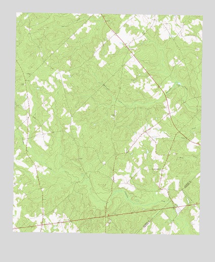
Lowery, GA USGS Topographic Map
Click on map above to begin viewing in our Map Viewer.

This topographic map contains these locations and features:
Feature Name Type Latitude Longitude GNIS ID View Map
Cedar Grove DivisionCivilN32.2985°W82.8407°1936167View Map
Gerard Gin (historical)LocaleN32.3641°W82.8079°346543View Map
Harrigan School (historical)SchoolN32.3616°W82.7693°346551View Map
Hatoff (historical)Populated PlaceN32.3118°W82.8079°346552View Map
Hatoff Church (historical)ChurchN32.3141°W82.8082°346553View Map
Laurens County Fire Department Station 16 LoweryBuildingN32.3108°W82.7826°2604469View Map
LoweryPopulated PlaceN32.3549°W82.7993°332277View Map
Lowery CemeteryCemeteryN32.2999°W82.8537°317467View Map
Lowery ChurchChurchN32.3546°W82.7987°346575View Map
Lowry Church (historical)ChurchN32.2907°W82.8165°346576View Map
Lowry School (historical)SchoolN32.2955°W82.8068°346577View Map
McRae ChurchChurchN32.3177°W82.8076°317976View Map
Miller CemeteryCemeteryN32.2874°W82.8304°318256View Map
Ochwalkee CreekStreamN32.3127°W82.8746°319889View Map
Pearlie ChurchChurchN32.3707°W82.8157°320322View Map
Race School (historical)SchoolN32.3566°W82.7999°346608View Map
Saint Marks ChurchChurchN32.3402°W82.8643°322180View Map
Swinson LakeReservoirN32.2852°W82.7965°340309View Map
Swinson Lake DamDamN32.2852°W82.7965°340308View Map
Walkee (historical)Populated PlaceN32.2949°W82.8660°346640View Map
White Spring School (historical)SchoolN32.2955°W82.7715°346646View Map
White Springs ChurchChurchN32.2868°W82.7757°325196View Map
Whitewater Church (historical)ChurchN32.3396°W82.7840°346647View Map
Windham GreenhousesBuildingN32.3283°W82.7703°2674803View Map

Note: Coordinates in the location and feature list above are referenced to NAD83 datum.


Copyright (C) 2008-2025 Ryan Niemi / Sunset Dynamics ... All Rights Reserved