TopoQuest Logo
Do you find TopoQuest useful?
Help keep TopoQuest running and adding new maps/features by donating!
Bitcoin:  19c7KJd3qBynnjoSw5npx9KScwjBe4ifkT
Litecoin:  LXs6TkuXGGXo1vDsWCkWVdjQX94eUKd6ui
Home View Maps Find Maps Find Places Resources & Links


Minter, Georgia Topographic Map

USGS Map Title: Minter, GA
USGS Map MRC: 32082D7
DRG (GeoTIFF) Download: o32082d7.tif


Neighboring USGS Topographic Map Quads:


  Dublin, GA  
32082E8
 

  East Dublin, GA  
32082E7
 

  Scott, GA  
32082E6
 

  Rentz, GA  
32082D8
 

  Minter, GA  
32082D7
 

  Rockledge, GA  
32082D6
 

  Five Points, GA  
32082C8
 

  Lowery, GA  
32082C7
 

  Lothair, GA  
32082C6


Map MRC Location:

N33°
W83°
N33°
W82°
H8 H7 H6 H5 H4 H3 H2 H1
G8 G7 G6 G5 G4 G3 G2 G1
F8 F7 F6 F5 F4 F3 F2 F1
E8 E7 E6 E5 E4 E3 E2 E1
D8 D7 D6 D5 D4 D3 D2 D1
C8 C7 C6 C5 C4 C3 C2 C1
B8 B7 B6 B5 B4 B3 B2 B1
A8 A7 A6 A5 A4 A3 A2 A1
N32°
W83°
N32°
W82°

Minter, GA USGS 1:24K Topographic Map Preview:
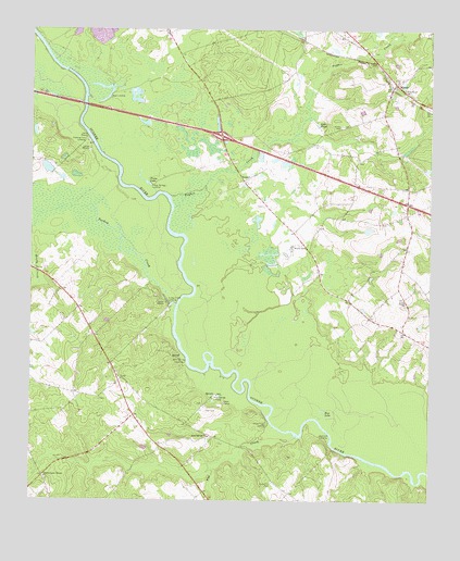
Minter, GA USGS Topographic Map
Click on map above to begin viewing in our Map Viewer.

This topographic map contains these locations and features:
Feature Name Type Latitude Longitude GNIS ID View Map
Barfield Gin (historical)LocaleN32.4624°W82.7574°346485View Map
Blue LakeLakeN32.3976°W82.7831°311550View Map
Braceville CemeteryCemeteryN32.3799°W82.7985°311697View Map
Cady Spring Church (historical)ChurchN32.4332°W82.7843°346500View Map
Daniel School (historical)SchoolN32.4154°W82.8743°346522View Map
Dead RiverLakeN32.4813°W82.8522°346523View Map
Diamond LandingLocaleN32.3916°W82.7812°331547View Map
Diamond Landing Ferry (historical)CrossingN32.3891°W82.7799°346526View Map
East Dublin DivisionCivilN32.4867°W82.7675°1936237View Map
Exit 16CrossingN32.4721°W82.8157°1705032View Map
Fishtrap Cut LandingLocaleN32.4707°W82.8576°355807View Map
Flat CreekStreamN32.3918°W82.7899°314178View Map
Hall CemeteryCemeteryN32.3988°W82.8196°315035View Map
Harmony School (historical)SchoolN32.4257°W82.8601°346550View Map
Lake LloydLakeN32.4752°W82.7853°317270View Map
Laurens County Fire Department Station 8 MinterBuildingN32.4989°W82.7747°2604493View Map
Lollie (historical)Populated PlaceN32.4816°W82.7560°346573View Map
Long Branch School (historical)SchoolN32.4532°W82.7574°346574View Map
MinterPopulated PlaceN32.4860°W82.7604°318322View Map
Minter CemeteryCemeteryN32.4746°W82.7771°318323View Map
Moore CemeteryCemeteryN32.4432°W82.7904°318434View Map
Pearly School (historical)SchoolN32.3943°W82.8393°346603View Map
Pine Level ChurchChurchN32.4843°W82.7576°320631View Map
Pughes CreekStreamN32.4527°W82.8293°321216View Map
Reedy CreekStreamN32.4507°W82.8718°321464View Map
Rising Rock School (historical)SchoolN32.3766°W82.8199°346610View Map
Rock Spring Fire DepartmentBuildingN32.4088°W82.8486°2604475View Map
Rock SpringsSpringN32.4035°W82.8168°346611View Map
Rock Springs ChurchChurchN32.3921°W82.8185°321753View Map
Rock Springs LandingLocaleN32.4021°W82.8171°332887View Map
Shaddock CreekStreamN32.4907°W82.8574°322734View Map
Shady Field LandingLocaleN32.3954°W82.8001°333009View Map
South Poplar Springs ChurchChurchN32.3810°W82.8701°323269View Map
Spivey Gin (historical)LocaleN32.4316°W82.7596°346624View Map
Tark Hill PondLakeN32.4575°W82.7930°346631View Map
Troup LakeLakeN32.4595°W82.8390°324334View Map
Troup SpringSpringN32.4585°W82.8374°346636View Map
Troup Spring LandingLocaleN32.4577°W82.8371°333266View Map
Turkey CreekStreamN32.4268°W82.8288°324378View Map
Turkey Creek LandingLocaleN32.4279°W82.8315°333275View Map
TweedPopulated PlaceN32.4291°W82.7579°346637View Map
Tweed ChurchChurchN32.4285°W82.7576°324432View Map
Tweed School (historical)SchoolN32.4285°W82.7576°346638View Map
Valdosta Baptist ChurchChurchN32.4646°W82.8126°346639View Map
Watson LakeReservoirN32.4632°W82.8698°335893View Map
Watson Lake DamDamN32.4618°W82.8682°335892View Map
Wells SpringSpringN32.4135°W82.8276°346643View Map
Wells Spring LandingLocaleN32.4116°W82.8260°333386View Map
Wilkes SpringSpringN32.3943°W82.7854°346650View Map

Note: Coordinates in the location and feature list above are referenced to NAD83 datum.


Copyright (C) 2008-2024 Ryan Niemi / Sunset Dynamics ... All Rights Reserved