TopoQuest Logo
Do you find TopoQuest useful?
Help keep TopoQuest running and adding new maps/features by donating!
Bitcoin:  19c7KJd3qBynnjoSw5npx9KScwjBe4ifkT
Litecoin:  LXs6TkuXGGXo1vDsWCkWVdjQX94eUKd6ui
Home View Maps Find Maps Find Places Resources & Links


McGee, Missouri Topographic Map

USGS Map Title: McGee, MO
USGS Map MRC: 37090A2
DRG (GeoTIFF) Download: o37090a2.tif


Neighboring USGS Topographic Map Quads:


  Lowndes, MO  
37090B3
 

  Gipsy, MO  
37090B2
 

  Zalma, MO  
37090B1
 

  Shook, MO  
37090A3
 

  McGee, MO  
37090A2
 

  Sturdivant, MO  
37090A1
 

  Wappapello, MO  
36090H3
 

  Puxico, MO  
36090H2
 

  Acorn Ridge, MO  
36090H1


Map MRC Location:

N38°
W91°
N38°
W90°
H8 H7 H6 H5 H4 H3 H2 H1
G8 G7 G6 G5 G4 G3 G2 G1
F8 F7 F6 F5 F4 F3 F2 F1
E8 E7 E6 E5 E4 E3 E2 E1
D8 D7 D6 D5 D4 D3 D2 D1
C8 C7 C6 C5 C4 C3 C2 C1
B8 B7 B6 B5 B4 B3 B2 B1
A8 A7 A6 A5 A4 A3 A2 A1
N37°
W91°
N37°
W90°

McGee, MO USGS 1:24K Topographic Map Preview:
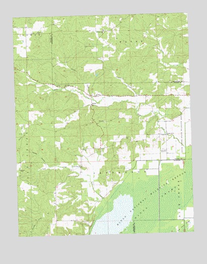
McGee, MO USGS Topographic Map
Click on map above to begin viewing in our Map Viewer.

This topographic map contains these locations and features:
Feature Name Type Latitude Longitude GNIS ID View Map
Bright Prospect ChurchChurchN37.0392°W90.2045°714703View Map
Corinth ChurchChurchN37.1162°W90.2326°716316View Map
De Celis CemeteryCemeteryN37.0587°W90.2434°735575View Map
DeCelis BranchStreamN37.0753°W90.1918°730484View Map
Ditch Number 2CanalN37.0137°W90.1318°755074View Map
Ditch Number 3CanalN37.0042°W90.1501°755099View Map
Ditch Number 4CanalN37.0039°W90.1682°755112View Map
Drum DamDamN37.0901°W90.2001°764464View Map
Drum LakeReservoirN37.0901°W90.2001°764465View Map
Fish School (historical)SchoolN37.1039°W90.1304°748028View Map
Flatwood School (historical)SchoolN37.1156°W90.1868°748027View Map
Fox PondReservoirN37.0267°W90.1851°758371View Map
Fry School (historical)SchoolN37.0064°W90.2232°748026View Map
Frye Church (historical)ChurchN37.0073°W90.2237°730483View Map
Gribler CreekStreamN37.0745°W90.1626°718872View Map
Gumstump PoolSwampN37.0162°W90.1632°736071View Map
Gypsy Lookout TowerTowerN37.1078°W90.1990°755197View Map
Horsehead KnollSummitN37.0262°W90.1470°736072View Map
Johns BranchStreamN37.0556°W90.2498°720344View Map
Lick CreekStreamN37.0181°W90.1870°721020View Map
Lurker HollowValleyN37.0398°W90.2282°721678View Map
Manning Cabin HollowValleyN37.0814°W90.1973°730481View Map
May PondReservoirN37.0037°W90.2023°736069View Map
McGeePopulated PlaceN37.0745°W90.1957°741053View Map
McGee CreekStreamN37.0484°W90.1295°750997View Map
McGee Gate Hunters EntranceLocaleN37.0453°W90.1429°732626View Map
McGee SchoolSchoolN37.0645°W90.1873°722109View Map
Mingo Refuge Fox Pond DamDamN37.0267°W90.1851°765534View Map
Mingo SwampSwampN37.0128°W90.1554°722438View Map
Monopoly MarshSwampN37.0078°W90.1801°736070View Map
Mount Pleasant ChurchChurchN37.1159°W90.1859°722860View Map
Mulenex LakeReservoirN37.1201°W90.1918°764470View Map
Mulenex Lake DamDamN37.1201°W90.1918°764469View Map
New Home ChurchChurchN37.0851°W90.2145°723220View Map
New Hope ChurchChurchN37.0792°W90.1926°723243View Map
Pioneer ChurchChurchN37.0559°W90.1429°724422View Map
Presidents Island Post Light (historical)BuildingN37.1167°W90.1667°2676078View Map
Puxico Quad Number 1 DamDamN37.0017°W90.2018°765596View Map
Richman CemeteryCemeteryN37.0384°W90.2479°748025View Map
Richmann ChapelChurchN37.0381°W90.2479°725279View Map
Rocky CreekStreamN37.0767°W90.1937°725508View Map
Shady Dell ChurchChurchN37.0562°W90.1423°726232View Map
Stilts BranchStreamN37.0484°W90.1295°730482View Map
Stilts School (historical)SchoolN37.0712°W90.1359°748029View Map
Sweet Asylum Hollow DamDamN37.1167°W90.1768°764467View Map
Sweet Asylum Hollow LakeReservoirN37.1167°W90.1768°764468View Map
Township of JeffersonCivilN37.0388°W90.1833°767520View Map
Wilfong CemeteryCemeteryN37.0078°W90.2051°735916View Map

Note: Coordinates in the location and feature list above are referenced to NAD83 datum.


Copyright (C) 2008-2024 Ryan Niemi / Sunset Dynamics ... All Rights Reserved