TopoQuest Logo
Do you find TopoQuest useful?
Help keep TopoQuest running and adding new maps/features by donating!
Bitcoin:  19c7KJd3qBynnjoSw5npx9KScwjBe4ifkT
Litecoin:  LXs6TkuXGGXo1vDsWCkWVdjQX94eUKd6ui
Home View Maps Find Maps Find Places Resources & Links


Baxterville NE, Mississippi Topographic Map

USGS Map Title: Baxterville NE, MS
USGS Map MRC: 31089B5
DRG (GeoTIFF) Download: o31089b5.tif


Neighboring USGS Topographic Map Quads:


  Improve, MS  
31089C6
 

  Oloh, MS  
31089C5
 

  Hattiesburg SW, MS  
31089C4
 

  Pinebur, MS  
31089B6
 

  Baxterville NE, MS  
31089B5
 

  Purvis, MS  
31089B4
 

  Baxterville SW, MS  
31089A6
 

  Baxterville, MS  
31089A5
 

  Lumberton, MS  
31089A4


Map MRC Location:

N32°
W90°
N32°
W89°
H8 H7 H6 H5 H4 H3 H2 H1
G8 G7 G6 G5 G4 G3 G2 G1
F8 F7 F6 F5 F4 F3 F2 F1
E8 E7 E6 E5 E4 E3 E2 E1
D8 D7 D6 D5 D4 D3 D2 D1
C8 C7 C6 C5 C4 C3 C2 C1
B8 B7 B6 B5 B4 B3 B2 B1
A8 A7 A6 A5 A4 A3 A2 A1
N31°
W90°
N31°
W89°

Baxterville NE, MS USGS 1:24K Topographic Map Preview:
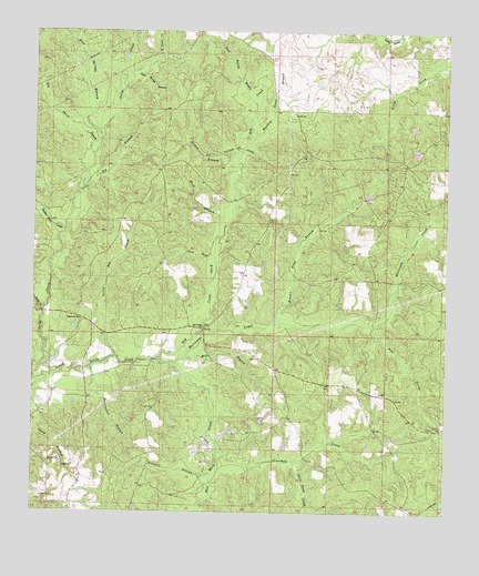
Baxterville NE, MS USGS Topographic Map
Click on map above to begin viewing in our Map Viewer.

This topographic map contains these locations and features:
Feature Name Type Latitude Longitude GNIS ID View Map
Alec ProngStreamN31.1735°W89.5228°666183View Map
Bay CreekStreamN31.1646°W89.5884°666581View Map
Bay Creek CemeteryCemeteryN31.1730°W89.5731°707448View Map
Bay Creek ChurchChurchN31.1732°W89.5737°666584View Map
Beaver Dam CreekStreamN31.1988°W89.6159°666712View Map
Beaver Pond BranchStreamN31.1743°W89.5523°666720View Map
Big BranchStreamN31.2096°W89.6109°667085View Map
Big Thick CreekStreamN31.2180°W89.6081°667155View Map
Blue Springs BranchStreamN31.2227°W89.6062°667323View Map
Bondity Ponds BranchStreamN31.2205°W89.5631°667421View Map
Buck BranchStreamN31.1993°W89.5684°667720View Map
Burnt School (historical)SchoolN31.1724°W89.5731°685770View Map
Caney ChurchChurchN31.1371°W89.6126°668035View Map
Clear Spring BranchStreamN31.2402°W89.5951°668587View Map
Driven BranchStreamN31.2146°W89.5642°669385View Map
East Gully CreekStreamN31.2399°W89.5965°669583View Map
Gall Berry BrakeStreamN31.2313°W89.5601°670300View Map
Grantham CreekStreamN31.1407°W89.5681°670596View Map
Greenville ChurchChurchN31.1749°W89.6109°670712View Map
Gum Reed BrakeStreamN31.1855°W89.5720°670798View Map
Half Moon CreekStreamN31.1635°W89.5840°670833View Map
Hickory HollowValleyN31.1341°W89.5712°671173View Map
Hurricane CreekStreamN31.1646°W89.5884°671621View Map
Jacks CreekStreamN31.1771°W89.6223°671764View Map
Lamar CountyCivilN31.2059°W89.5087°695760View Map
Lamar Lookout TowerTowerN31.1471°W89.5015°711258View Map
Little Bay CreekStreamN31.1652°W89.6006°672535View Map
Mill BranchStreamN31.1649°W89.5798°673580View Map
Southwest Lamar Volunteer Fire Department Station 2BuildingN31.1728°W89.5728°2332767View Map
Spice Pond CreekStreamN31.1385°W89.5456°678053View Map
Supervisor District 3CivilN31.1457°W89.5444°711935View Map
Sweetwater BranchStreamN31.1624°W89.6081°678489View Map
Tatums CampsLocaleN31.2168°W89.5351°685814View Map
Wolf BranchStreamN31.1252°W89.5753°679804View Map
York S Lake DamDamN31.1252°W89.5367°680582View Map

Note: Coordinates in the location and feature list above are referenced to NAD83 datum.


Copyright (C) 2008-2024 Ryan Niemi / Sunset Dynamics ... All Rights Reserved