TopoQuest Logo
Do you find TopoQuest useful?
Help keep TopoQuest running and adding new maps/features by donating!
Bitcoin:  19c7KJd3qBynnjoSw5npx9KScwjBe4ifkT
Litecoin:  LXs6TkuXGGXo1vDsWCkWVdjQX94eUKd6ui
Home View Maps Find Maps Find Places Resources & Links


Pinebur, Mississippi Topographic Map

USGS Map Title: Pinebur, MS
USGS Map MRC: 31089B6
DRG (GeoTIFF) Download: o31089b6.tif


Neighboring USGS Topographic Map Quads:


  Columbia North, MS  
31089C7
 

  Improve, MS  
31089C6
 

  Oloh, MS  
31089C5
 

  Columbia South, MS  
31089B7
 

  Pinebur, MS  
31089B6
 

  Baxterville NE, MS  
31089B5
 

  Sandy Hook, MS  
31089A7
 

  Baxterville SW, MS  
31089A6
 

  Baxterville, MS  
31089A5


Map MRC Location:

N32°
W90°
N32°
W89°
H8 H7 H6 H5 H4 H3 H2 H1
G8 G7 G6 G5 G4 G3 G2 G1
F8 F7 F6 F5 F4 F3 F2 F1
E8 E7 E6 E5 E4 E3 E2 E1
D8 D7 D6 D5 D4 D3 D2 D1
C8 C7 C6 C5 C4 C3 C2 C1
B8 B7 B6 B5 B4 B3 B2 B1
A8 A7 A6 A5 A4 A3 A2 A1
N31°
W90°
N31°
W89°

Pinebur, MS USGS 1:24K Topographic Map Preview:
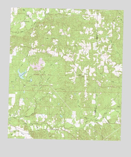
Pinebur, MS USGS Topographic Map
Click on map above to begin viewing in our Map Viewer.

This topographic map contains these locations and features:
Feature Name Type Latitude Longitude GNIS ID View Map
Beaver Dam CreekStreamN31.1366°W89.6690°666709View Map
Beets AirportAirportN31.2053°W89.7491°2770533View Map
Big CreekStreamN31.2343°W89.7248°667094View Map
Bill Waller Lake DamDamN31.2002°W89.7167°680604View Map
Boggy ProngStreamN31.2460°W89.7329°666082View Map
Breakfield CemeteryCemeteryN31.2424°W89.7301°667535View Map
Brushy CreekStreamN31.2332°W89.7262°666083View Map
Brushy Creek ChurchChurchN31.2368°W89.7345°667694View Map
Caney BranchStreamN31.1557°W89.6328°668034View Map
Cook CemeteryCemeteryN31.2110°W89.7253°668777View Map
Earkan Lake DamDamN31.1585°W89.6951°680595View Map
Elbow BranchStreamN31.1796°W89.7156°669711View Map
Graves CreekStreamN31.2435°W89.7129°666101View Map
Gully CreekStreamN31.1577°W89.6262°670780View Map
Hollywood SpringSpringN31.1865°W89.6735°671344View Map
Lake Bill WallerReservoirN31.1950°W89.7183°689650View Map
Lake ColumbiaReservoirN31.1857°W89.7370°668718View Map
Lake Columbia DamDamN31.1835°W89.7384°680600View Map
Lake WattsReservoirN31.1807°W89.7253°679390View Map
Little Prong CreekStreamN31.1463°W89.7367°672655View Map
Long BranchStreamN31.1443°W89.6537°672798View Map
Marion County State Wildlife Management AreaParkN31.1835°W89.7126°689686View Map
Mill BranchStreamN31.1441°W89.6517°673584View Map
Pine Burr Volunteer Fire DepartmentBuildingN31.1418°W89.6891°2667727View Map
PineburPopulated PlaceN31.1360°W89.7020°692150View Map
Pinebur CemeteryCemeteryN31.1457°W89.6623°710569View Map
Pinebur ChurchChurchN31.1463°W89.6629°675884View Map
Pitman CreekStreamN31.1485°W89.6442°675946View Map
Pitman Creek School (historical)SchoolN31.1418°W89.6390°685801View Map
Sheep Pen BranchStreamN31.1585°W89.7190°677632View Map
Supervisor District 5CivilN31.1356°W89.7321°711981View Map
Tom Watts Lake DamDamN31.1802°W89.7251°680599View Map
Turkey BranchStreamN31.1585°W89.7190°678941View Map
Union School (historical)SchoolN31.2360°W89.7340°689710View Map

Note: Coordinates in the location and feature list above are referenced to NAD83 datum.


Copyright (C) 2008-2025 Ryan Niemi / Sunset Dynamics ... All Rights Reserved