TopoQuest Logo
Do you find TopoQuest useful?
Help keep TopoQuest running and adding new maps/features by donating!
Bitcoin:  19c7KJd3qBynnjoSw5npx9KScwjBe4ifkT
Litecoin:  LXs6TkuXGGXo1vDsWCkWVdjQX94eUKd6ui
Home View Maps Find Maps Find Places Resources & Links


Macon, North Carolina Topographic Map

USGS Map Title: Macon, NC
USGS Map MRC: 36078D1
DRG (GeoTIFF) Download: o36078d1.tif


Neighboring USGS Topographic Map Quads:


  Bracey, VA  
36078E2
 

  South Hill SE, VA  
36078E1
 

  Gasburg, VA  
36077E8
 

  Warrenton, NC  
36078D2
 

  Macon, NC  
36078D1
 

  Littleton, NC  
36077D8
 

  Afton, NC  
36078C2
 

  Inez, NC  
36078C1
 

  Hollister, NC  
36077C8


Map MRC Location:

N37°
W79°
N37°
W78°
H8 H7 H6 H5 H4 H3 H2 H1
G8 G7 G6 G5 G4 G3 G2 G1
F8 F7 F6 F5 F4 F3 F2 F1
E8 E7 E6 E5 E4 E3 E2 E1
D8 D7 D6 D5 D4 D3 D2 D1
C8 C7 C6 C5 C4 C3 C2 C1
B8 B7 B6 B5 B4 B3 B2 B1
A8 A7 A6 A5 A4 A3 A2 A1
N36°
W79°
N36°
W78°

Macon, NC USGS 1:24K Topographic Map Preview:
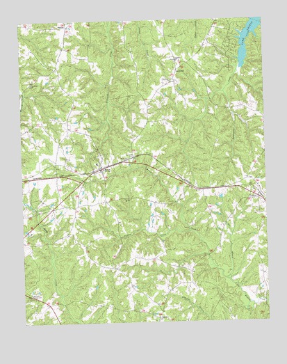
Macon, NC USGS Topographic Map
Click on map above to begin viewing in our Map Viewer.

This topographic map contains these locations and features:
Feature Name Type Latitude Longitude GNIS ID View Map
Big BranchStreamN36.3926°W78.0208°981352View Map
Church HillPopulated PlaceN36.4793°W78.0447°1019675View Map
Churchill Five Forks Volunteer Fire DepartmentBuildingN36.4942°W78.0493°2639524View Map
Dowtins CreekStreamN36.4129°W78.0380°1020025View Map
EmbroPopulated PlaceN36.3765°W78.0550°984760View Map
Gardners ChurchChurchN36.4835°W78.0444°985566View Map
Greenwood CemeteryCemeteryN36.4443°W78.0672°986124View Map
MaconPopulated PlaceN36.4388°W78.0839°989216View Map
Macon ChurchChurchN36.4432°W78.0711°989217View Map
Macon Post OfficePost OfficeN36.4380°W78.0854°2774172View Map
Macon Rural Fire DepartmentBuildingN36.4387°W78.0833°2639319View Map
Mount Zion ChurchChurchN36.4263°W78.0725°990677View Map
New Bethel ChurchChurchN36.4740°W78.1192°990943View Map
OakvillePopulated PlaceN36.4976°W78.1005°1021713View Map
Pine Grove ChurchChurchN36.4749°W78.0480°992246View Map
Town of MaconCivilN36.4396°W78.0839°2406072View Map
Township of SixpoundCivilN36.4869°W78.0559°1027287View Map
VaughanPopulated PlaceN36.4265°W78.0036°996597View Map
Walkers CreekStreamN36.3926°W78.0208°996706View Map
Warren CountyCivilN36.3965°W78.1067°1008593View Map
Warrenton Country ClubLocaleN36.3879°W78.1197°996810View Map

Note: Coordinates in the location and feature list above are referenced to NAD83 datum.


Copyright (C) 2008-2025 Ryan Niemi / Sunset Dynamics ... All Rights Reserved