TopoQuest Logo
Do you find TopoQuest useful?
Help keep TopoQuest running and adding new maps/features by donating!
Bitcoin:  19c7KJd3qBynnjoSw5npx9KScwjBe4ifkT
Litecoin:  LXs6TkuXGGXo1vDsWCkWVdjQX94eUKd6ui
Home View Maps Find Maps Find Places Resources & Links


Gasburg, Virginia Topographic Map

USGS Map Title: Gasburg, VA
USGS Map MRC: 36077E8
DRG (GeoTIFF) Download: o36077e8.tif


Neighboring USGS Topographic Map Quads:


  La Crosse, VA  
36078F1
 

  White Plains, VA  
36077F8
 

  Powellton, VA  
36077F7
 

  South Hill SE, VA  
36078E1
 

  Gasburg, VA  
36077E8
 

  Valentines, VA  
36077E7
 

  Macon, NC  
36078D1
 

  Littleton, NC  
36077D8
 

  Thelma, NC  
36077D7


Map MRC Location:

N37°
W78°
N37°
W77°
H8 H7 H6 H5 H4 H3 H2 H1
G8 G7 G6 G5 G4 G3 G2 G1
F8 F7 F6 F5 F4 F3 F2 F1
E8 E7 E6 E5 E4 E3 E2 E1
D8 D7 D6 D5 D4 D3 D2 D1
C8 C7 C6 C5 C4 C3 C2 C1
B8 B7 B6 B5 B4 B3 B2 B1
A8 A7 A6 A5 A4 A3 A2 A1
N36°
W78°
N36°
W77°

Gasburg, VA USGS 1:24K Topographic Map Preview:
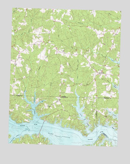
Gasburg, VA USGS Topographic Map
Click on map above to begin viewing in our Map Viewer.

This topographic map contains these locations and features:
Feature Name Type Latitude Longitude GNIS ID View Map
AnkumPopulated PlaceN36.6035°W77.8808°1494811View Map
Antioch ChurchChurchN36.5399°W77.9458°980253View Map
Clary CemeteryCemeteryN36.5874°W77.9103°1464954View Map
EbonyPopulated PlaceN36.5788°W77.9908°1477290View Map
Ebony Census Designated PlaceCensusN36.5759°W77.9840°2584840View Map
Ebony Post OfficePost OfficeN36.5815°W77.9904°2767212View Map
Ebony Volunteer Fire DepartmentBuildingN36.5821°W77.9910°2075968View Map
ElamsPopulated PlaceN36.5413°W77.9428°1006195View Map
GasburgPopulated PlaceN36.5668°W77.8955°1477342View Map
Gasburg Post OfficePost OfficeN36.5675°W77.8970°2767218View Map
Gasburg Volunteer Fire DepartmentBuildingN36.5648°W77.8910°2075527View Map
Hardy Spring BranchStreamN36.5682°W77.9236°1467744View Map
Hubquarter CreekStreamN36.5163°W77.9786°987202View Map
Kirkland CemeteryCemeteryN36.5865°W77.9839°1469041View Map
Lizard CreekStreamN36.5118°W77.9061°988826View Map
Mill CreekStreamN36.5354°W77.9694°989939View Map
Oak CornerLocaleN36.6099°W77.9347°1494013View Map
Pigeonroost CreekStreamN36.5363°W77.9742°992185View Map
Pleasant Hill CemeteryCemeteryN36.5818°W77.8900°1472490View Map
Pleasant Hill ChurchChurchN36.5696°W77.8953°1472491View Map
Powell CemeteryCemeteryN36.5949°W77.9553°1472729View Map
Prospect CemeteryCemeteryN36.5724°W77.9953°1494021View Map
Prospect ChurchChurchN36.5724°W77.9950°1472807View Map
Reid CemeteryCemeteryN36.5918°W77.9742°1473138View Map
Roanoke - Wildwood Volunteer Fire DepartmentBuildingN36.5308°W77.9061°2638345View Map
Roanoke ChapelChurchN36.5357°W77.9547°993412View Map
Saint Pauls ChapelChurchN36.5563°W77.9100°1473862View Map
Songbird CreekStreamN36.5226°W77.9689°995111View Map
Tillans ChapelChurchN36.5265°W77.8892°996104View Map
Township of RoanokeCivilN36.5304°W77.9565°1027284View Map

Note: Coordinates in the location and feature list above are referenced to NAD83 datum.


Copyright (C) 2008-2024 Ryan Niemi / Sunset Dynamics ... All Rights Reserved