TopoQuest Logo
Do you find TopoQuest useful?
Help keep TopoQuest running and adding new maps/features by donating!
Bitcoin:  19c7KJd3qBynnjoSw5npx9KScwjBe4ifkT
Litecoin:  LXs6TkuXGGXo1vDsWCkWVdjQX94eUKd6ui
Home View Maps Find Maps Find Places Resources & Links


South Hill SE, Virginia Topographic Map

USGS Map Title: South Hill SE, VA
USGS Map MRC: 36078E1
DRG (GeoTIFF) Download: o36078e1.tif


Neighboring USGS Topographic Map Quads:


  South Hill, VA  
36078F2
 

  La Crosse, VA  
36078F1
 

  White Plains, VA  
36077F8
 

  Bracey, VA  
36078E2
 

  South Hill SE, VA  
36078E1
 

  Gasburg, VA  
36077E8
 

  Warrenton, NC  
36078D2
 

  Macon, NC  
36078D1
 

  Littleton, NC  
36077D8


Map MRC Location:

N37°
W79°
N37°
W78°
H8 H7 H6 H5 H4 H3 H2 H1
G8 G7 G6 G5 G4 G3 G2 G1
F8 F7 F6 F5 F4 F3 F2 F1
E8 E7 E6 E5 E4 E3 E2 E1
D8 D7 D6 D5 D4 D3 D2 D1
C8 C7 C6 C5 C4 C3 C2 C1
B8 B7 B6 B5 B4 B3 B2 B1
A8 A7 A6 A5 A4 A3 A2 A1
N36°
W79°
N36°
W78°

South Hill SE, VA USGS 1:24K Topographic Map Preview:
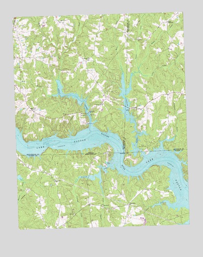
South Hill SE, VA USGS Topographic Map
Click on map above to begin viewing in our Map Viewer.

This topographic map contains these locations and features:
Feature Name Type Latitude Longitude GNIS ID View Map
Barker CrossroadsPopulated PlaceN36.6199°W78.0117°1499090View Map
Bethel Grove ChurchChurchN36.6221°W78.0894°1463210View Map
Boyds Island (historical)IslandN36.5507°W78.0969°1500626View Map
Bracey Census Designated PlaceCensusN36.5762°W78.1107°2584812View Map
Cedar GrovePopulated PlaceN36.6038°W78.0108°1493966View Map
Churchill Five Forks Volunteer Fire Department SubstationBuildingN36.5387°W78.0714°2638678View Map
Ebony School (historical)SchoolN36.5801°W78.0044°1493974View Map
Five ForksPopulated PlaceN36.5135°W78.0430°985128View Map
Good Hope ChurchChurchN36.6101°W78.0330°1467204View Map
Good Hope School (historical)SchoolN36.6168°W78.0178°1493981View Map
Great CreekStreamN36.5596°W78.0694°1467424View Map
Great Creek ChurchChurchN36.5707°W78.1117°1467427View Map
Greenback (historical)LocaleN36.5140°W78.0736°1007018View Map
Hagood CreekStreamN36.5979°W78.0886°1467633View Map
Hebron ChurchChurchN36.5085°W78.0839°986586View Map
Holly Grove ChurchChurchN36.5688°W78.0700°1468157View Map
Jordan CreekStreamN36.5313°W78.0650°987777View Map
Jordan Hill ChurchChurchN36.5129°W78.0628°987780View Map
JoycevillePopulated PlaceN36.5696°W78.0364°1499614View Map
Lake GastonReservoirN36.5359°W78.0552°985605View Map
Lake Gaston Volunteer Fire Department Company 8BuildingN36.5661°W78.0902°2086165View Map
Little Poplar CreekStreamN36.5913°W78.0336°1469622View Map
Long BranchStreamN36.5782°W78.0964°1469785View Map
Lyons CreekStreamN36.5126°W78.0061°989158View Map
Middle CreekStreamN36.5929°W78.0336°1470396View Map
Miles CreekStreamN36.5807°W78.0444°1470459View Map
Moodys Ferry (historical)LocaleN36.5299°W78.0017°1007118View Map
Nocarva AirportAirportN36.5391°W78.0579°2679218View Map
Pleasant Hill ChurchChurchN36.5282°W78.0975°992544View Map
Poplar CreekStreamN36.5410°W78.0311°992686View Map
Rehobeth ChurchChurchN36.5993°W78.0705°1500798View Map
Rehoboth ChurchChurchN36.5996°W78.0697°1473132View Map
Saint Stephens ChurchChurchN36.5729°W78.0614°1473908View Map
Saint Stevens School (historical)SchoolN36.5740°W78.0605°1500813View Map
Siouan Scout ReservationParkN36.5465°W78.0322°1474634View Map
Sixpound CreekStreamN36.5379°W78.0533°994873View Map
Stillhouse BranchStreamN36.5460°W78.0189°1475140View Map

Note: Coordinates in the location and feature list above are referenced to NAD83 datum.


Copyright (C) 2008-2025 Ryan Niemi / Sunset Dynamics ... All Rights Reserved