TopoQuest Logo
Do you find TopoQuest useful?
Help keep TopoQuest running and adding new maps/features by donating!
Bitcoin:  19c7KJd3qBynnjoSw5npx9KScwjBe4ifkT
Litecoin:  LXs6TkuXGGXo1vDsWCkWVdjQX94eUKd6ui
Home View Maps Find Maps Find Places Resources & Links


Madison, West Virginia Topographic Map

USGS Map Title: Madison, WV
USGS Map MRC: 38081A7
DRG (GeoTIFF) Download: o38081a7.tif


Neighboring USGS Topographic Map Quads:


  Griffithsville, WV  
38081B8
 

  Julian, WV  
38081B7
 

  Racine, WV  
38081B6
 

  Mud, WV  
38081A8
 

  Madison, WV  
38081A7
 

  Williams Mountain, WV  
38081A6
 

  Henlawson, WV  
37081H8
 

  Clothier, WV  
37081H7
 

  Wharton, WV  
37081H6


Map MRC Location:

N39°
W82°
N39°
W81°
H8 H7 H6 H5 H4 H3 H2 H1
G8 G7 G6 G5 G4 G3 G2 G1
F8 F7 F6 F5 F4 F3 F2 F1
E8 E7 E6 E5 E4 E3 E2 E1
D8 D7 D6 D5 D4 D3 D2 D1
C8 C7 C6 C5 C4 C3 C2 C1
B8 B7 B6 B5 B4 B3 B2 B1
A8 A7 A6 A5 A4 A3 A2 A1
N38°
W82°
N38°
W81°

Madison, WV USGS 1:24K Topographic Map Preview:
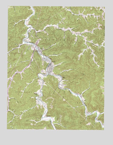
Madison, WV USGS Topographic Map
Click on map above to begin viewing in our Map Viewer.

This topographic map contains these locations and features:
Feature Name Type Latitude Longitude GNIS ID View Map
Ball ForkStreamN38.0193°W81.8735°1535182View Map
Ballard BranchStreamN38.1004°W81.7929°1535186View Map
Ballard CemeteryCemeteryN38.0995°W81.8465°1535188View Map
Ballard CemeteryCemeteryN38.1029°W81.7937°1535189View Map
Benjamin Price BridgeBridgeN38.0707°W81.8195°2635295View Map
Bias CemeteryCemeteryN38.0176°W81.8660°1535754View Map
Boone - Madison Public LibraryBuildingN38.0640°W81.8223°2727191View Map
Boone Career and Technical CenterSchoolN38.1033°W81.8096°2088137View Map
Boone County Ambulance Authority Medic Station 15BuildingN38.0590°W81.8209°2780096View Map
Boone County Ambulance Authority Medic Station 20BuildingN38.0845°W81.8419°2581059View Map
Boone County CourthouseBuildingN38.0663°W81.8199°2727828View Map
Boone County Sheriff's OfficeBuildingN38.0665°W81.8190°2727870View Map
Boone Memorial HospitalHospitalN38.0482°W81.8062°1741713View Map
Boone Memorial ParkCemeteryN38.0483°W81.8312°2724761View Map
Brookview Elementary SchoolSchoolN38.1042°W81.8258°2088142View Map
Brown BranchStreamN38.1168°W81.8426°1536401View Map
Browns BranchStreamN38.0873°W81.8457°1536428View Map
Camp Creek ChurchChurchN38.1168°W81.7668°1536918View Map
Camp Creek School (historical)SchoolN38.1173°W81.7893°1536921View Map
Canterberry CemeteryCemeteryN38.0190°W81.8676°1537015View Map
Cantley BranchStreamN38.0954°W81.7854°1537021View Map
Chambers CemeteryCemeteryN38.0859°W81.8610°1537184View Map
City of MadisonCivilN38.0631°W81.8046°2390612View Map
Cooper CemeteryCemeteryN38.0776°W81.7654°1537647View Map
DanvillePopulated PlaceN38.0809°W81.8340°1537999View Map
Danville BridgeBridgeN38.0846°W81.8384°2635293View Map
Danville Elementary School (historical)SchoolN38.0795°W81.8318°1741726View Map
Danville Police DepartmentBuildingN38.0794°W81.8320°2727871View Map
Danville Post OfficePost OfficeN38.0766°W81.8311°1741727View Map
Danville Volunteer Fire DepartmentBuildingN38.0786°W81.8352°2577726View Map
District 3CivilN38.0929°W81.8524°1928226View Map
Dolin CemeteryCemeteryN38.1007°W81.7912°1538254View Map
Dolin CemeteryCemeteryN38.1154°W81.7593°1538255View Map
Dry BranchStreamN38.1182°W81.8421°1538334View Map
Easter ForkStreamN38.1218°W81.7957°1538527View Map
Echols CemeteryCemeteryN38.1065°W81.8201°1538542View Map
FochPopulated PlaceN38.0401°W81.7929°1554479View Map
FosterPopulated PlaceN38.0973°W81.7798°1554499View Map
Foster Post OfficePost OfficeN38.0991°W81.7734°1741735View Map
Gomez CemeteryCemeteryN38.0298°W81.7757°1539495View Map
Green Bias CemeteryCemeteryN38.0582°W81.8651°1539663View Map
Griffith BranchStreamN38.0259°W81.7751°1539742View Map
Griffith CemeteryCemeteryN38.1232°W81.8457°1539743View Map
Gunnoes CemeteryCemeteryN38.1026°W81.8040°1539795View Map
HaddletonPopulated PlaceN38.0445°W81.8304°1741743View Map
Halstead CemeteryCemeteryN38.1026°W81.8026°1539870View Map
Hill BranchStreamN38.1229°W81.8432°1540279View Map
HopkinsPopulated PlaceN38.0904°W81.8537°1741750View Map
Hopkins BranchStreamN38.0732°W81.8226°1540452View Map
Hopkins CemeteryCemeteryN38.0904°W81.8523°1540453View Map
Hubbard ForkStreamN38.0957°W81.7807°1540541View Map
Hunters BranchStreamN38.0048°W81.8162°1549513View Map
Indian Grave BranchStreamN38.0326°W81.8732°1540691View Map
Jarrell BranchStreamN38.0343°W81.7829°1540823View Map
Jarrell CemeteryCemeteryN38.0137°W81.7710°1540827View Map
Jill Micaah Hess BridgeBridgeN38.0847°W81.8386°2635294View Map
Laurel BranchStreamN38.0332°W81.8326°1541378View Map
Lawson CemeteryCemeteryN38.0054°W81.7501°1541564View Map
Left Fork Lick CreekStreamN38.0693°W81.8748°1541679View Map
Left Fork Rock CreekStreamN38.0901°W81.7726°1541712View Map
Lick CreekStreamN38.0884°W81.8529°1541885View Map
Long BranchStreamN38.0695°W81.8435°1542344View Map
Low GapPopulated PlaceN38.0315°W81.8357°1542497View Map
Low Gap BranchStreamN38.0987°W81.8373°1542500View Map
Low Gap CreekStreamN38.0298°W81.8335°1542507View Map
LT Darwin K Kyle Memorial BridgeBridgeN38.0586°W81.8245°2635289View Map
Mack Gore BranchStreamN38.0157°W81.7707°1542671View Map
MadisonPopulated PlaceN38.0670°W81.8193°1542678View Map
Madison Elementary Preschool Annex (historical)SchoolN38.0340°W81.7801°2088138View Map
Madison Elementary SchoolSchoolN38.0627°W81.8166°1741766View Map
Madison Memorial ParkParkN38.0487°W81.8310°1542681View Map
Madison Middle SchoolSchoolN38.0724°W81.8276°2088254View Map
Madison Police DepartmentBuildingN38.0593°W81.8208°2727869View Map
Madison Post OfficePost OfficeN38.0617°W81.8231°1741767View Map
Madison Volunteer Fire DepartmentBuildingN38.0669°W81.8200°2577601View Map
Memory GardensCemeteryN38.0279°W81.8323°1543119View Map
Miller CemeteryCemeteryN38.0201°W81.8710°1543361View Map
Miller CemeteryCemeteryN38.0532°W81.8310°1543363View Map
Miller CemeteryCemeteryN38.0759°W81.7626°1543364View Map
Miller CemeteryCemeteryN38.0898°W81.7751°1543365View Map
Miller CemeteryCemeteryN38.0901°W81.7726°1543366View Map
Mud ForkStreamN38.0548°W81.8665°1543904View Map
Mullins CemeteryCemeteryN38.0857°W81.8182°1544000View Map
Olive Branch Missionary Baptist Church (historical)ChurchN38.0359°W81.8737°1741777View Map
Pedee ForkStreamN38.0845°W81.7710°1544683View Map
Perdue CemeteryCemeteryN38.0976°W81.7848°1544713View Map
Pond ForkStreamN38.0562°W81.8223°1545127View Map
Powell CreekPopulated PlaceN38.0134°W81.8254°1545215View Map
Powell CreekStreamN38.0120°W81.8290°1545216View Map
Price BranchStreamN38.0412°W81.8015°1545247View Map
Price BranchStreamN38.0768°W81.8337°1545248View Map
Price CemeteryCemeteryN38.0404°W81.8021°1545251View Map
Price CemeteryCemeteryN38.0998°W81.8468°1545252View Map
Price HillPopulated PlaceN38.0434°W81.8071°1545259View Map
QuinlandPopulated PlaceN38.0168°W81.7701°1555427View Map
Quinland ChurchChurchN38.0259°W81.7760°1545352View Map
Raccoon BranchStreamN38.0337°W81.8735°1545357View Map
Right Fork Rock CreekStreamN38.0901°W81.7729°1545690View Map
Riley Hill CemeteryCemeteryN38.1168°W81.8401°1545748View Map
Riverview Country Club Golf CourseLocaleN38.0112°W81.8227°2634166View Map
Robinson CreekStreamN38.0154°W81.7571°1545865View Map
Rock CreekStreamN38.1026°W81.8479°1545901View Map
Rock CreekPopulated PlaceN38.1032°W81.8460°1549900View Map
Rock Creek School (historical)SchoolN38.0993°W81.8365°1545904View Map
Rucker BranchStreamN38.0659°W81.8218°1546134View Map
Scott High SchoolSchoolN38.0728°W81.8302°1741799View Map
Shaw BranchStreamN38.1023°W81.8057°1546635View Map
Slippery Gut BranchStreamN38.1104°W81.8515°1546949View Map
South MadisonPopulated PlaceN38.0537°W81.8057°1555669View Map
Sparrow CreekStreamN38.0534°W81.8340°1547108View Map
Spruce ForkStreamN38.0562°W81.8223°1547242View Map
Sugarcamp BranchStreamN38.1157°W81.7751°1547664View Map
Sulphur Spring BranchStreamN38.0437°W81.8087°1547715View Map
Thomas Price BranchStreamN38.0543°W81.7793°1548031View Map
Town of DanvilleCivilN38.0808°W81.8343°2390820View Map
Trace BranchStreamN38.1054°W81.8121°1548191View Map
Trace BranchStreamN38.0101°W81.7593°1548197View Map
Turtle CreekStreamN38.0818°W81.8376°1548386View Map
Turtle CreekPopulated PlaceN38.0298°W81.8729°1555842View Map
Turtle Creek Post OfficePost OfficeN38.0343°W81.8748°1741812View Map
TurtletownPopulated PlaceN38.0193°W81.8735°1741813View Map
UneedaPopulated PlaceN38.0357°W81.7807°1548460View Map
Uneeda Grade School (historical)SchoolN38.0340°W81.7798°1741815View Map
Uneeda Post OfficePost OfficeN38.0368°W81.7858°1741816View Map
Van CampPopulated PlaceN38.1229°W81.8440°1741817View Map
Vandelinde CemeteryCemeteryN38.1015°W81.8062°1548625View Map
Washington HeightsPopulated PlaceN38.0357°W81.8315°1555923View Map
West Virginia Division of Forestry Boone County Field OfficeBuildingN38.0794°W81.8319°2577804View Map
West Virginia State Police Troop 5BuildingN38.0835°W81.8426°2727872View Map
Williams CemeteryCemeteryN38.0909°W81.7671°1549170View Map
Workman BranchStreamN38.0551°W81.8085°1549402View Map
Workman KnobSummitN38.0562°W81.7748°1549419View Map
WZAC-AM (Madison)TowerN38.0568°W81.8187°1559721View Map
WZAC-FM (Danville)TowerN38.0837°W81.8046°1559781View Map

Note: Coordinates in the location and feature list above are referenced to NAD83 datum.


Copyright (C) 2008-2024 Ryan Niemi / Sunset Dynamics ... All Rights Reserved