TopoQuest Logo
Do you find TopoQuest useful?
Help keep TopoQuest running and adding new maps/features by donating!
Bitcoin:  19c7KJd3qBynnjoSw5npx9KScwjBe4ifkT
Litecoin:  LXs6TkuXGGXo1vDsWCkWVdjQX94eUKd6ui
Home View Maps Find Maps Find Places Resources & Links


Racine, West Virginia Topographic Map

USGS Map Title: Racine, WV
USGS Map MRC: 38081B6
DRG (GeoTIFF) Download: o38081b6.tif


Neighboring USGS Topographic Map Quads:


  Alum Creek, WV  
38081C7
 

  Charleston West, WV  
38081C6
 

  Charleston East, WV  
38081C5
 

  Julian, WV  
38081B7
 

  Racine, WV  
38081B6
 

  Belle, WV  
38081B5
 

  Madison, WV  
38081A7
 

  Williams Mountain, WV  
38081A6
 

  Sylvester, WV  
38081A5


Map MRC Location:

N39°
W82°
N39°
W81°
H8 H7 H6 H5 H4 H3 H2 H1
G8 G7 G6 G5 G4 G3 G2 G1
F8 F7 F6 F5 F4 F3 F2 F1
E8 E7 E6 E5 E4 E3 E2 E1
D8 D7 D6 D5 D4 D3 D2 D1
C8 C7 C6 C5 C4 C3 C2 C1
B8 B7 B6 B5 B4 B3 B2 B1
A8 A7 A6 A5 A4 A3 A2 A1
N38°
W82°
N38°
W81°

Racine, WV USGS 1:24K Topographic Map Preview:
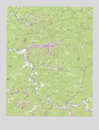
Racine, WV USGS Topographic Map
Click on map above to begin viewing in our Map Viewer.

This topographic map contains these locations and features:
Feature Name Type Latitude Longitude GNIS ID View Map
AshfordPopulated PlaceN38.1793°W81.7110°1549571View Map
Ashford Church of GodChurchN38.1795°W81.7110°1741704View Map
Ashford Post OfficePost OfficeN38.1793°W81.7112°1741705View Map
Ashford Rumble Elementary SchoolSchoolN38.1837°W81.7007°1741706View Map
Barker CemeteryCemeteryN38.1473°W81.6865°1535224View Map
Barker CemeteryCemeteryN38.1801°W81.6751°1535225View Map
Barker CemeteryCemeteryN38.1854°W81.7187°1535226View Map
BloomingrosePopulated PlaceN38.1426°W81.6332°1536113View Map
Bloomingrose Post OfficePost OfficeN38.1440°W81.6358°1741711View Map
Boone County Ambulance Authority 40BuildingN38.1389°W81.6540°2581033View Map
BradleyPopulated PlaceN38.1584°W81.7173°1553960View Map
Brier BranchStreamN38.1587°W81.7051°1536343View Map
Brier Creek TabernacleChurchN38.2345°W81.7304°1536347View Map
Brush CreekStreamN38.1670°W81.7118°1536465View Map
BrushtonPopulated PlaceN38.1662°W81.7090°1549613View Map
Brushy BranchStreamN38.2370°W81.7090°1536486View Map
Bull CreekStreamN38.1993°W81.7223°1536690View Map
Burgess HollowValleyN38.1770°W81.6726°1536738View Map
Charles R Carrico Memorial BridgeBridgeN38.1362°W81.6820°2635298View Map
Coal River Branch LibraryBuildingN38.1384°W81.6478°2727190View Map
Costa Post OfficePost OfficeN38.1661°W81.7092°1721384View Map
Courtney CemeteryCemeteryN38.1768°W81.6621°1537715View Map
Curtis BranchStreamN38.1693°W81.7148°1537937View Map
Curtis Branch DamDamN38.1718°W81.6948°1557386View Map
DartmontPopulated PlaceN38.1915°W81.7223°1554257View Map
Davis Creek Camping AreaLocaleN38.2465°W81.6590°1538040View Map
Davis Creek Picnic AreaLocaleN38.2420°W81.6540°1538041View Map
Drawdy CreekStreamN38.1395°W81.6826°1538312View Map
Drawdy Falls Roadside ParkParkN38.1340°W81.6876°1538314View Map
Dry BranchStreamN38.2007°W81.7429°1538336View Map
DungriffPopulated PlaceN38.2404°W81.7140°1549663View Map
EaslyPopulated PlaceN38.1523°W81.7332°1538500View Map
EdenPopulated PlaceN38.1320°W81.6296°1554365View Map
Evans CemeteryCemeteryN38.1415°W81.6554°1538755View Map
Falling Rock ForkStreamN38.1798°W81.6771°1538863View Map
Fauber CemeteryCemeteryN38.1459°W81.6318°1538906View Map
Ferneys BranchStreamN38.2257°W81.6896°1538926View Map
First Baptist Church of RacineChurchN38.1404°W81.6562°1741734View Map
Foster CemeteryCemeteryN38.1473°W81.6571°1539165View Map
Foster HollowValleyN38.1459°W81.6573°1539167View Map
GrippePopulated PlaceN38.1990°W81.7362°1554617View Map
Holstein CemeteryCemeteryN38.1959°W81.7210°1540407View Map
Holstein HollowValleyN38.2340°W81.7240°1540409View Map
Honeycamp ForkStreamN38.1518°W81.7240°1540426View Map
Indian CreekStreamN38.1359°W81.6618°1540671View Map
Indian Creek CemeteryCemeteryN38.1270°W81.6540°1540677View Map
Javins CemeteryCemeteryN38.1363°W81.7058°1540837View Map
Javins CemeteryCemeteryN38.1370°W81.7072°1540838View Map
JohnsPopulated PlaceN38.1487°W81.7015°1554816View Map
Kinder CemeteryCemeteryN38.1673°W81.7143°1541204View Map
Kirk CemeteryCemeteryN38.1762°W81.6615°1541237View Map
Left Fork Brier CreekStreamN38.2473°W81.7348°1541636View Map
Left Fork Bull CreekStreamN38.2045°W81.7121°1541639View Map
Leon Memorial TabernacleChurchN38.2345°W81.7262°1541787View Map
Lick CreekStreamN38.1804°W81.7112°1541881View Map
LicoPopulated PlaceN38.2415°W81.7390°1541952View Map
Little Rich ForkStreamN38.2051°W81.6712°1542192View Map
Log Town Hollow Picnic AreaLocaleN38.2440°W81.6540°1542309View Map
Loggy HollowValleyN38.1337°W81.7373°1542318View Map
Longs HollowValleyN38.2034°W81.6890°1542436View Map
Lower Drawdy School (historical)SchoolN38.1362°W81.6815°1741764View Map
Mahone ChapelChurchN38.1784°W81.6737°1542697View Map
Mary ForkStreamN38.2109°W81.6271°1542835View Map
McDerment CemeteryCemeteryN38.1851°W81.6926°1542984View Map
Meadow Fork Brier CreekStreamN38.2409°W81.7390°1543065View Map
Mechanics and Miners CemeteryCemeteryN38.1412°W81.6373°1543105View Map
Mikes RunStreamN38.1984°W81.7215°1543244View Map
Mill BranchStreamN38.1429°W81.6610°1543293View Map
Morris CemeteryCemeteryN38.1970°W81.7304°1543562View Map
Morris CemeteryCemeteryN38.1984°W81.7351°1543563View Map
NellisPopulated PlaceN38.1509°W81.7426°1555196View Map
Nellis Elementary SchoolSchoolN38.1500°W81.7447°1741774View Map
Nellis Post OfficePost OfficeN38.1502°W81.7432°1741775View Map
OlcottPopulated PlaceN38.2345°W81.7243°1544344View Map
Perry CemeteryCemeteryN38.1851°W81.6893°1544726View Map
PeytonaPopulated PlaceN38.1415°W81.6846°1555337View Map
Peytona BridgeBridgeN38.1366°W81.6792°2635296View Map
Peytona Church of ChristChurchN38.1429°W81.6857°1741781View Map
Peytona Grade School (historical)SchoolN38.1370°W81.6807°1741782View Map
Peytona Post OfficePost OfficeN38.1371°W81.6785°1741783View Map
Porter CemeteryCemeteryN38.1440°W81.6332°1545158View Map
Price CemeteryCemeteryN38.1731°W81.6682°1545253View Map
RacinePopulated PlaceN38.1420°W81.6604°1545368View Map
Racine Census Designated PlaceCensusN38.1398°W81.6540°2586871View Map
Racine Methodist ChurchChurchN38.1398°W81.6615°1741788View Map
Racine Post OfficePost OfficeN38.1583°W81.6413°1741790View Map
Racine Volunteer Fire DepartmentBuildingN38.1378°W81.6482°2577595View Map
Racine-Peytona Elementary School (historical)SchoolN38.1390°W81.6540°1741789View Map
Rich ForkStreamN38.2073°W81.6762°1545544View Map
Road ForkStreamN38.2073°W81.6762°1545804View Map
Roundbottom CreekStreamN38.1434°W81.6873°1546113View Map
RumblePopulated PlaceN38.1834°W81.6993°1555538View Map
Sentz Lick BranchStreamN38.2370°W81.7487°1546575View Map
SharlowPopulated PlaceN38.1326°W81.6343°1549924View Map
Short CreekStreamN38.1423°W81.6590°1546723View Map
Snodgrass CemeteryCemeteryN38.1770°W81.6890°1547036View Map
Spruce ForkStreamN38.2401°W81.7151°1547244View Map
Sugarcamp ForkStreamN38.2415°W81.7443°1547676View Map
Thomas BranchStreamN38.2009°W81.7457°1548020View Map
Toneys BranchStreamN38.1426°W81.6337°1548165View Map
Wade CemeteryCemeteryN38.1515°W81.6837°1548693View Map
Walker CreekStreamN38.1493°W81.7451°1548723View Map
Walker HollowValleyN38.1809°W81.6860°1548727View Map
Welch BranchStreamN38.1968°W81.7332°1548888View Map
White Oak BranchStreamN38.1857°W81.7151°1549039View Map
White Oak CreekStreamN38.1404°W81.6957°1549055View Map
Workman CemeteryCemeteryN38.1395°W81.6510°1549413View Map

Note: Coordinates in the location and feature list above are referenced to NAD83 datum.


Copyright (C) 2008-2025 Ryan Niemi / Sunset Dynamics ... All Rights Reserved