TopoQuest Logo
Do you find TopoQuest useful?
Help keep TopoQuest running and adding new maps/features by donating!
Bitcoin:  19c7KJd3qBynnjoSw5npx9KScwjBe4ifkT
Litecoin:  LXs6TkuXGGXo1vDsWCkWVdjQX94eUKd6ui
Home View Maps Find Maps Find Places Resources & Links


Williams Mountain, West Virginia Topographic Map

USGS Map Title: Williams Mountain, WV
USGS Map MRC: 38081A6
DRG (GeoTIFF) Download: o38081a6.tif


Neighboring USGS Topographic Map Quads:


  Julian, WV  
38081B7
 

  Racine, WV  
38081B6
 

  Belle, WV  
38081B5
 

  Madison, WV  
38081A7
 

  Williams Mountain, WV  
38081A6
 

  Sylvester, WV  
38081A5
 

  Clothier, WV  
37081H7
 

  Wharton, WV  
37081H6
 

  Whitesville, WV  
37081H5


Map MRC Location:

N39°
W82°
N39°
W81°
H8 H7 H6 H5 H4 H3 H2 H1
G8 G7 G6 G5 G4 G3 G2 G1
F8 F7 F6 F5 F4 F3 F2 F1
E8 E7 E6 E5 E4 E3 E2 E1
D8 D7 D6 D5 D4 D3 D2 D1
C8 C7 C6 C5 C4 C3 C2 C1
B8 B7 B6 B5 B4 B3 B2 B1
A8 A7 A6 A5 A4 A3 A2 A1
N38°
W82°
N38°
W81°

Williams Mountain, WV USGS 1:24K Topographic Map Preview:
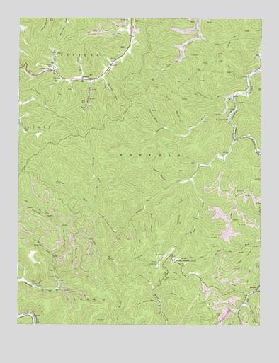
Williams Mountain, WV USGS Topographic Map
Click on map above to begin viewing in our Map Viewer.

This topographic map contains these locations and features:
Feature Name Type Latitude Longitude GNIS ID View Map
AndrewPopulated PlaceN38.1001°W81.7173°1534950View Map
Atha ChapelChurchN38.1001°W81.7146°1535071View Map
Bennett ForkStreamN38.0282°W81.7321°1535633View Map
Bias CemeteryCemeteryN38.1082°W81.7032°1535756View Map
Big Mountain Slurry PondReservoirN38.0018°W81.6482°1557384View Map
Boone CountyCivilN38.0230°W81.7112°1550009View Map
Burnside BranchStreamN38.1007°W81.7079°1536758View Map
Cabin ForkStreamN38.0154°W81.7290°1536828View Map
Chesterfield Mine Siltation PondReservoirN38.0218°W81.7198°1557393View Map
Chrisley ForkStreamN38.0590°W81.6643°1537325View Map
Cold ForkStreamN38.0607°W81.6610°1537502View Map
District 1CivilN38.0893°W81.6340°1928204View Map
Dolans ForkStreamN38.0101°W81.6765°1538253View Map
Drawdy CemeteryCemeteryN38.1247°W81.6938°1538310View Map
Drawdy ChurchChurchN38.1107°W81.7315°1538311View Map
Drawdy Creek ChurchChurchN38.1037°W81.7335°1538313View Map
Frozen HollowValleyN38.0326°W81.6287°1539283View Map
George BranchStreamN38.0579°W81.6704°1539371View Map
Harless CemeteryCemeteryN38.1051°W81.7335°1539961View Map
Hopkins ForkPopulated PlaceN38.0832°W81.6412°1540454View Map
Hopkins ForkStreamN38.0759°W81.6382°1540455View Map
Horse HollowValleyN38.0159°W81.6804°1540489View Map
Jarrells CemeteryCemeteryN38.0254°W81.6782°1540831View Map
Laurel BranchStreamN38.0995°W81.7171°1541383View Map
Little Jarrells CreekStreamN38.0095°W81.6323°1542134View Map
Little Laurel CreekStreamN38.0445°W81.7071°1542144View Map
Long BranchStreamN38.0795°W81.6615°1542345View Map
Lots BranchStreamN38.0059°W81.6368°1542474View Map
Lots BranchStreamN38.0123°W81.6309°1741763View Map
Lotts Branch Slurry Impoundment DamDamN38.0018°W81.6482°1557383View Map
Low Point HollowValleyN38.0087°W81.6768°1542513View Map
Miller CemeteryCemeteryN38.0998°W81.7287°1543367View Map
Morgan BranchStreamN38.0995°W81.7112°1543528View Map
Mudlick ForkStreamN38.0487°W81.7112°1543946View Map
Orchard BranchStreamN38.0801°W81.6751°1544434View Map
Potato BranchStreamN38.0479°W81.6851°1545181View Map
PrenterPopulated PlaceN38.0145°W81.6271°1545237View Map
Prenter Post OfficePost OfficeN38.0126°W81.6309°1741786View Map
Road Fork Dam Number 1 UpperDamN38.0218°W81.7198°1557392View Map
Road Fork Dam Number 2 LowerDamN38.0184°W81.7282°1557394View Map
Ruffys ForkStreamN38.0148°W81.6798°1546146View Map
Sandlick CreekStreamN38.0934°W81.6387°1546393View Map
Sterling (historical)Populated PlaceN38.1176°W81.6571°1741808View Map
Stolling ForkStreamN38.0487°W81.7112°1547441View Map
Three Fork BranchStreamN38.0923°W81.6415°1548061View Map
Toney ForkStreamN38.1032°W81.7318°1548159View Map
Williams CemeteryCemeteryN38.0287°W81.6740°1549169View Map
Williams Hill Lookout TowerLocaleN38.0251°W81.6779°1741827View Map
Williams MountainPopulated PlaceN38.0259°W81.6693°1555990View Map
Williams Mountain Post OfficePost OfficeN38.0279°W81.6701°1741828View Map

Note: Coordinates in the location and feature list above are referenced to NAD83 datum.


Copyright (C) 2008-2025 Ryan Niemi / Sunset Dynamics ... All Rights Reserved