TopoQuest Logo
Do you find TopoQuest useful?
Help keep TopoQuest running and adding new maps/features by donating!
Bitcoin:  19c7KJd3qBynnjoSw5npx9KScwjBe4ifkT
Litecoin:  LXs6TkuXGGXo1vDsWCkWVdjQX94eUKd6ui
Home View Maps Find Maps Find Places Resources & Links


Mangas Springs, New Mexico Topographic Map

USGS Map Title: Mangas Springs, NM
USGS Map MRC: 32108G5
DRG (GeoTIFF) Download: o32108g5.tif


Neighboring USGS Topographic Map Quads:


  Antelope Ridge, NM  
32108H6
 

  Cliff, NM  
32108H5
 

  Dorsey Ranch, NM  
32108H4
 

  Brushy Mountain, NM  
32108G6
 

  Mangas Springs, NM  
32108G5
 

  Circle Mesa, NM  
32108G4
 

  Redrock, NM  
32108F6
 

  Bullard Peak, NM  
32108F5
 

  Wind Mountain, NM  
32108F4


Map MRC Location:

N33°
W109°
N33°
W108°
H8 H7 H6 H5 H4 H3 H2 H1
G8 G7 G6 G5 G4 G3 G2 G1
F8 F7 F6 F5 F4 F3 F2 F1
E8 E7 E6 E5 E4 E3 E2 E1
D8 D7 D6 D5 D4 D3 D2 D1
C8 C7 C6 C5 C4 C3 C2 C1
B8 B7 B6 B5 B4 B3 B2 B1
A8 A7 A6 A5 A4 A3 A2 A1
N32°
W109°
N32°
W108°

Mangas Springs, NM USGS 1:24K Topographic Map Preview:
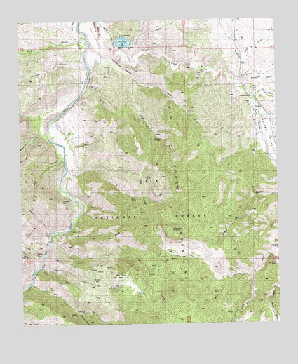
Mangas Springs, NM USGS Topographic Map
Click on map above to begin viewing in our Map Viewer.

This topographic map contains these locations and features:
Feature Name Type Latitude Longitude GNIS ID View Map
Adobe SpringSpringN32.7878°W108.6239°885571View Map
Adobe SpringSpringN32.7801°W108.6037°1766229View Map
Barney Kerr TankReservoirN32.7870°W108.5174°2038357View Map
Bear CanyonValleyN32.7673°W108.6201°903631View Map
Big Burro MountainsRangeN32.8134°W108.5417°920561View Map
Bill Evans LakeReservoirN32.8661°W108.5748°914447View Map
Bill Evans Lake DamDamN32.8634°W108.5739°923907View Map
Black Hawk CanyonValleyN32.7795°W108.5023°903864View Map
Black Hawk WindmillLocaleN32.7804°W108.5014°2038370View Map
Black Hay WindmillLocaleN32.7798°W108.5009°886409View Map
BlackhawkMineN32.7759°W108.5023°914909View Map
Blackmoor MineMineN32.7679°W108.5945°886468View Map
Blacksmith CanyonValleyN32.8506°W108.5187°903906View Map
Blue Stone TankReservoirN32.8440°W108.5317°2038375View Map
Blue Stone WellWellN32.7562°W108.5059°2038376View Map
Bone TankReservoirN32.8284°W108.6026°2038379View Map
Boundary TankReservoirN32.8004°W108.5284°2038381View Map
Butterfly SeepSpringN32.7742°W108.5564°915929View Map
Buzzard BayBasinN32.7684°W108.5867°886999View Map
Buzzard CanyonValleyN32.7734°W108.6153°887000View Map
Cake CanyonValleyN32.8229°W108.6239°936527View Map
Cake Canyon TankReservoirN32.8198°W108.6209°2038392View Map
Cherokee CanyonValleyN32.8551°W108.5923°905068View Map
Cora Miller MineMineN32.8537°W108.5367°887833View Map
Cordell CanyonValleyN32.8440°W108.5128°905336View Map
Cottonwood CanyonValleyN32.8317°W108.5087°887895View Map
Dale McCauley RanchLocaleN32.8292°W108.6053°888181View Map
Davis CanyonValleyN32.8648°W108.5923°905618View Map
Dud CanyonValleyN32.8348°W108.5045°905897View Map
East Fork Schoolhouse CanyonValleyN32.8520°W108.5703°888659View Map
East Prong SpringSpringN32.8348°W108.5398°2038450View Map
Faucet CanyonValleyN32.7867°W108.6112°936528View Map
Fence Line TankReservoirN32.8001°W108.5242°2038464View Map
Fleming Canyon ProspectsMineN32.7892°W108.5839°921056View Map
Grapevine SpringSpringN32.8258°W108.5602°936530View Map
Grassy Flat TankReservoirN32.7788°W108.5270°2038487View Map
Hap McCauley RanchLocaleN32.8573°W108.5845°889753View Map
Ira CanyonValleyN32.8120°W108.6003°890347View Map
Ira Canyon TankReservoirN32.8115°W108.5676°2038511View Map
Ira RidgeRidgeN32.7851°W108.5867°890348View Map
Juniper TankReservoirN32.8020°W108.5520°2038526View Map
Lebus Recreation Reservoir DamDamN32.8634°W108.5739°923904View Map
Little Bear CanyonValleyN32.7545°W108.5978°907986View Map
Little WindmillLocaleN32.8240°W108.6014°2038542View Map
Mangas CreekStreamN32.8637°W108.5909°908385View Map
Mangas LakeLakeN32.8395°W108.5114°891572View Map
Mangas SpringsPopulated PlaceN32.8426°W108.5117°920641View Map
Mangas ValleyValleyN32.8637°W108.5909°908388View Map
Miller CanyonValleyN32.7704°W108.5139°892048View Map
Miller SpringSpringN32.7631°W108.5306°2038573View Map
Moonhull CanyonValleyN32.8281°W108.6151°908884View Map
North Fork Ira CanyonValleyN32.8142°W108.5889°892592View Map
North Fork Wild Horse CanyonValleyN32.7717°W108.5637°892599View Map
Old Smokey GroupMineN32.8401°W108.5551°914857View Map
Pancho CanyonValleyN32.8481°W108.5917°893059View Map
Patterson CanyonValleyN32.8234°W108.5992°893120View Map
Patterson WindmillLocaleN32.8270°W108.5856°2038613View Map
Pig TankReservoirN32.7876°W108.5684°2038617View Map
Purple Heart MineMineN32.7667°W108.5823°893562View Map
Purple Heart TankReservoirN32.7656°W108.5823°2038634View Map
Pyrite CanyonValleyN32.7790°W108.6145°909909View Map
Ramsey SaddleGapN32.7734°W108.5853°893643View Map
Road CanyonValleyN32.8190°W108.6059°936534View Map
Saddle RockSummitN32.7740°W108.5045°894252View Map
Saint Peters RockSummitN32.7923°W108.6089°936531View Map
Schoolhouse CanyonValleyN32.8590°W108.5803°894654View Map
Schoolhouse MountainSummitN32.7887°W108.5523°894655View Map
Schoolhouse WindmillLocaleN32.8151°W108.5303°2038671View Map
Sheep Corral DrawValleyN32.8520°W108.5162°910988View Map
South Fork Buzzard CanyonValleyN32.7712°W108.6067°895042View Map
Telegraph (historical)Populated PlaceN32.7790°W108.6248°925106View Map
Telegraph MineMineN32.7790°W108.6248°911588View Map
Tony CorralLocaleN32.7556°W108.5059°2038717View Map
Tub SpringSpringN32.8045°W108.5752°936532View Map
West Fork Schoolhouse CanyonValleyN32.8520°W108.5706°896368View Map
West Prong WindmillLocaleN32.8429°W108.5703°2038753View Map
Wild Horse CanyonValleyN32.7867°W108.6070°896590View Map
Wild Horse MesaSummitN32.7695°W108.5798°920735View Map
Wild Horse SpringSpringN32.7681°W108.5656°2038760View Map

Note: Coordinates in the location and feature list above are referenced to NAD83 datum.


Copyright (C) 2008-2025 Ryan Niemi / Sunset Dynamics ... All Rights Reserved