TopoQuest Logo
Do you find TopoQuest useful?
Help keep TopoQuest running and adding new maps/features by donating!
Bitcoin:  19c7KJd3qBynnjoSw5npx9KScwjBe4ifkT
Litecoin:  LXs6TkuXGGXo1vDsWCkWVdjQX94eUKd6ui
Home View Maps Find Maps Find Places Resources & Links


Antelope Ridge, New Mexico Topographic Map

USGS Map Title: Antelope Ridge, NM
USGS Map MRC: 32108H6
DRG (GeoTIFF) Download: o32108h6.tif


Neighboring USGS Topographic Map Quads:


  Bear Mountain, NM  
33108A7
 

  Buckhorn, NM  
33108A6
 

  Canteen Canyon, NM  
33108A5
 

  Applegate Mountain, NM  
32108H7
 

  Antelope Ridge, NM  
32108H6
 

  Cliff, NM  
32108H5
 

  Walker Canyon, NM  
32108G7
 

  Brushy Mountain, NM  
32108G6
 

  Mangas Springs, NM  
32108G5


Map MRC Location:

N33°
W109°
N33°
W108°
H8 H7 H6 H5 H4 H3 H2 H1
G8 G7 G6 G5 G4 G3 G2 G1
F8 F7 F6 F5 F4 F3 F2 F1
E8 E7 E6 E5 E4 E3 E2 E1
D8 D7 D6 D5 D4 D3 D2 D1
C8 C7 C6 C5 C4 C3 C2 C1
B8 B7 B6 B5 B4 B3 B2 B1
A8 A7 A6 A5 A4 A3 A2 A1
N32°
W109°
N32°
W108°

Antelope Ridge, NM USGS 1:24K Topographic Map Preview:
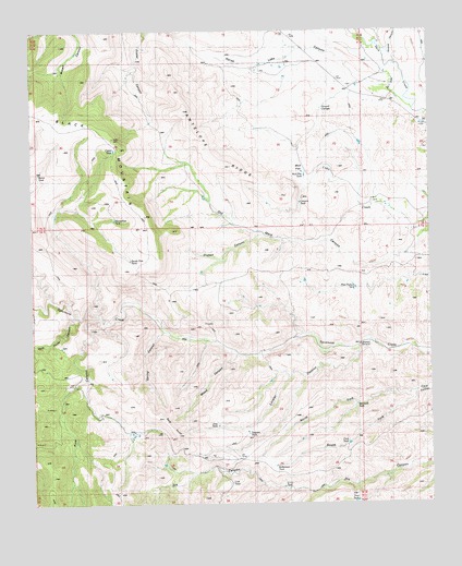
Antelope Ridge, NM USGS Topographic Map
Click on map above to begin viewing in our Map Viewer.

This topographic map contains these locations and features:
Feature Name Type Latitude Longitude GNIS ID View Map
Antelope RidgeRidgeN32.9670°W108.6942°885783View Map
Bald KnollSummitN32.8970°W108.7009°886015View Map
BennettLocaleN32.9551°W108.6426°929695View Map
Big Dix WindmillLocaleN32.8856°W108.6259°886298View Map
Black MountainSummitN32.9720°W108.7245°886438View Map
Bradberry RanchLocaleN32.8934°W108.7187°886697View Map
Burnt TankReservoirN32.9626°W108.7482°886949View Map
Cabin TankReservoirN32.9688°W108.7244°887050View Map
Canyon TankReservoirN32.9546°W108.6660°887160View Map
CCC TankReservoirN32.8795°W108.6721°887027View Map
Clark TankReservoirN32.8910°W108.6515°887649View Map
Clark WindmillLocaleN32.9042°W108.6378°887652View Map
Cow CampLocaleN32.9695°W108.7245°887969View Map
Horse Lake CanyonValleyN32.9848°W108.6389°907097View Map
Horseshoe TankLakeN32.9504°W108.7244°890196View Map
Howard CienegaSwampN32.9801°W108.6564°890221View Map
Hunter WindmillLocaleN32.9934°W108.6870°890268View Map
Joes TankReservoirN32.8957°W108.6925°890476View Map
Leachman DrawValleyN32.9984°W108.6451°907907View Map
Line TankReservoirN32.8807°W108.6884°891090View Map
Little Dix WindmillLocaleN32.8778°W108.6631°891131View Map
Lockler CanyonValleyN32.9151°W108.6473°891244View Map
Mud FlatFlatN32.9648°W108.6620°892301View Map
Mud Flat TankReservoirN32.9617°W108.6646°902308View Map
Norris RanchLocaleN32.9153°W108.6781°892554View Map
North Fork Clark CanyonValleyN32.9045°W108.6292°892589View Map
Old Maid CanyonValleyN32.9459°W108.6267°892873View Map
Orphan CanyonValleyN32.9456°W108.6784°892937View Map
Pine CanyonValleyN32.9070°W108.7362°909655View Map
Pine TankReservoirN32.8757°W108.6491°893284View Map
Pitts Pasture TankReservoirN32.9320°W108.6490°893349View Map
Robertson TankReservoirN32.8851°W108.6745°894022View Map
Rock House CanyonValleyN32.9245°W108.7359°910371View Map
Shields CanyonValleyN32.9945°W108.6356°911013View Map
South End TankReservoirN32.9397°W108.7195°895039View Map
South Fork Clark CanyonValleyN32.9045°W108.6292°895046View Map
Spring CanyonValleyN32.9198°W108.7095°895247View Map
Stout CemeteryCemeteryN32.9687°W108.6275°895382View Map
Tadpole TankReservoirN32.8937°W108.6830°902365View Map
Wallace RanchLocaleN32.8995°W108.7317°896208View Map
Wallace Ranch Perlite DepositMineN32.9026°W108.7392°914936View Map
Willmeth TankReservoirN32.9011°W108.6489°896651View Map
Willmeth WindmillLocaleN32.9170°W108.6470°896652View Map
Wood CanyonValleyN32.9131°W108.6867°896740View Map

Note: Coordinates in the location and feature list above are referenced to NAD83 datum.


Copyright (C) 2008-2024 Ryan Niemi / Sunset Dynamics ... All Rights Reserved