TopoQuest Logo
Do you find TopoQuest useful?
Help keep TopoQuest running and adding new maps/features by donating!
Bitcoin:  19c7KJd3qBynnjoSw5npx9KScwjBe4ifkT
Litecoin:  LXs6TkuXGGXo1vDsWCkWVdjQX94eUKd6ui
Home View Maps Find Maps Find Places Resources & Links


Mansfield, Missouri Topographic Map

USGS Map Title: Mansfield, MO
USGS Map MRC: 37092A5
DRG (GeoTIFF) Download: o37092a5.tif


Neighboring USGS Topographic Map Quads:


  Mansfield NW, MO  
37092B6
 

  Mansfield NE, MO  
37092B5
 

  Owens, MO  
37092B4
 

  Cedar Gap, MO  
37092A6
 

  Mansfield, MO  
37092A5
 

  Norwood, MO  
37092A4
 

  Ava, MO  
36092H6
 

  Sweden, MO  
36092H5
 

  Brushyknob, MO  
36092H4


Map MRC Location:

N38°
W93°
N38°
W92°
H8 H7 H6 H5 H4 H3 H2 H1
G8 G7 G6 G5 G4 G3 G2 G1
F8 F7 F6 F5 F4 F3 F2 F1
E8 E7 E6 E5 E4 E3 E2 E1
D8 D7 D6 D5 D4 D3 D2 D1
C8 C7 C6 C5 C4 C3 C2 C1
B8 B7 B6 B5 B4 B3 B2 B1
A8 A7 A6 A5 A4 A3 A2 A1
N37°
W93°
N37°
W92°

Mansfield, MO USGS 1:24K Topographic Map Preview:
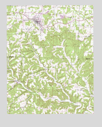
Mansfield, MO USGS Topographic Map
Click on map above to begin viewing in our Map Viewer.

This topographic map contains these locations and features:
Feature Name Type Latitude Longitude GNIS ID View Map
Ashley ChurchChurchN37.1187°W92.5116°713440View Map
Baker CemeteryCemeteryN37.0809°W92.6235°713561View Map
Bouser HollowValleyN37.0384°W92.5529°714565View Map
BryantPopulated PlaceN37.0389°W92.6107°740702View Map
Buzzard HollowValleyN37.0373°W92.6060°715151View Map
City of MansfieldCivilN37.1102°W92.5804°2395834View Map
Crain CemeteryCemeteryN37.0817°W92.6196°716458View Map
Deaker CemeteryCemeteryN37.0988°W92.5983°716770View Map
Department of Conservation Ozark Field Fire Office MansfieldBuildingN37.1029°W92.5803°2621596View Map
Dyer CemeteryCemeteryN37.0000°W92.6010°743034View Map
Endeavor School (historical)SchoolN37.0495°W92.5007°733861View Map
Fairview ChurchChurchN37.0270°W92.5218°717771View Map
Findley CemeteryCemeteryN37.0923°W92.5029°717915View Map
Flat Rock SchoolSchoolN37.0931°W92.6071°717998View Map
Hicks HollowValleyN37.0353°W92.6018°719498View Map
Hicks SchoolSchoolN37.0467°W92.5885°719500View Map
Highway ChurchChurchN37.0034°W92.6229°719592View Map
Huffman School (historical)SchoolN37.0153°W92.5446°733863View Map
Keith CemeteryCemeteryN37.0400°W92.5363°720491View Map
KTRI-FM (Mansfield)TowerN37.1123°W92.5691°759081View Map
Laura Ingalls Wilder HouseBuildingN37.1006°W92.5636°2463143View Map
MansfieldPopulated PlaceN37.1067°W92.5807°721807View Map
Mansfield Fire DepartmentBuildingN37.1073°W92.5803°2621209View Map
Mansfield Police DepartmentBuildingN37.1075°W92.5820°2752302View Map
Mansfield Post OfficePost OfficeN37.1055°W92.5798°2782931View Map
MidwayPopulated PlaceN37.0295°W92.5952°741064View Map
Mill HollowValleyN37.0351°W92.6091°722357View Map
Mount Everett ChurchChurchN37.0373°W92.6049°722749View Map
Mount Pleasant ChurchChurchN37.0514°W92.5688°722859View Map
Oak Grove School (historical)SchoolN37.0167°W92.6249°733859View Map
OlathiaPopulated PlaceN37.0273°W92.5196°735765View Map
Prairie HollowValleyN37.0164°W92.5357°724860View Map
Privet HollowValleyN37.0498°W92.6182°724943View Map
Puncheon Camp CreekStreamN37.0195°W92.5029°725000View Map
Rockhouse HollowValleyN37.0239°W92.5879°735822View Map
Rockhouse SchoolSchoolN37.0073°W92.6016°725485View Map
Roy School (historical)SchoolN37.0534°W92.5488°733860View Map
Shiloh ChurchChurchN37.0226°W92.5021°735852View Map
Shiloh School (historical)SchoolN37.0234°W92.5107°733862View Map
Shinpaugh RidgeRidgeN37.0312°W92.5574°726385View Map
Smelter HollowValleyN37.0520°W92.6213°726570View Map
South Fork Dry CreekStreamN37.0078°W92.5077°726737View Map
Spence School (historical)SchoolN37.1112°W92.5385°735067View Map
Township of MillerCivilN37.0216°W92.5783°766628View Map
Township of Pleasant ValleyCivilN37.1093°W92.6024°767553View Map
Wallace CemeteryCemeteryN37.0298°W92.6049°728276View Map
Winkle HollowValleyN37.0206°W92.5746°729004View Map
Wolf Creek ChurchChurchN37.1112°W92.5354°729053View Map

Note: Coordinates in the location and feature list above are referenced to NAD83 datum.


Copyright (C) 2008-2024 Ryan Niemi / Sunset Dynamics ... All Rights Reserved