TopoQuest Logo
Do you find TopoQuest useful?
Help keep TopoQuest running and adding new maps/features by donating!
Bitcoin:  19c7KJd3qBynnjoSw5npx9KScwjBe4ifkT
Litecoin:  LXs6TkuXGGXo1vDsWCkWVdjQX94eUKd6ui
Home View Maps Find Maps Find Places Resources & Links


Manti, Utah Topographic Map

USGS Map Title: Manti, UT
USGS Map MRC: 39111C6
DRG (GeoTIFF) Download: o39111c6.tif


Neighboring USGS Topographic Map Quads:


  Chriss Canyon, UT  
39111D7
 

  Wales, UT  
39111D6
 

  Chester, UT  
39111D5
 

  Hells Kitchen Canyon SE, UT  
39111C7
 

  Manti, UT  
39111C6
 

  Ephraim, UT  
39111C5
 

  Gunnison, UT  
39111B7
 

  Sterling, UT  
39111B6
 

  Black Mountain, UT  
39111B5


Map MRC Location:

N40°
W112°
N40°
W111°
H8 H7 H6 H5 H4 H3 H2 H1
G8 G7 G6 G5 G4 G3 G2 G1
F8 F7 F6 F5 F4 F3 F2 F1
E8 E7 E6 E5 E4 E3 E2 E1
D8 D7 D6 D5 D4 D3 D2 D1
C8 C7 C6 C5 C4 C3 C2 C1
B8 B7 B6 B5 B4 B3 B2 B1
A8 A7 A6 A5 A4 A3 A2 A1
N39°
W112°
N39°
W111°

Manti, UT USGS 1:24K Topographic Map Preview:
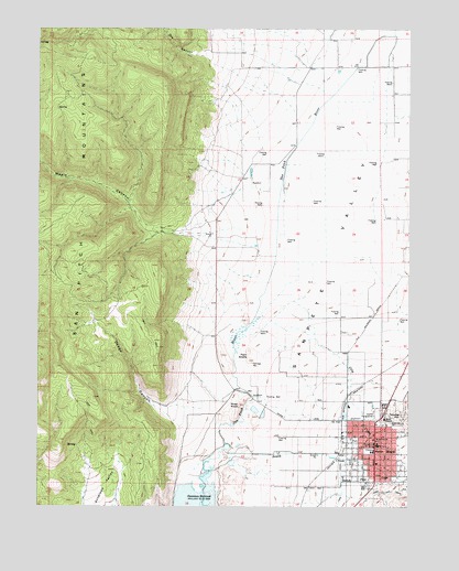
Manti, UT USGS Topographic Map
Click on map above to begin viewing in our Map Viewer.

This topographic map contains these locations and features:
Feature Name Type Latitude Longitude GNIS ID View Map
City CreekStreamN39.2908°W111.6730°1426650View Map
City of MantiCivilN39.2670°W111.6375°2411025View Map
Davis Trailer Court and RV CampgroundLocaleN39.2633°W111.6391°1435389View Map
Dodge CanyonValleyN39.2758°W111.6974°1427433View Map
Dry CanyonValleyN39.3661°W111.6930°1440586View Map
High Water CanalCanalN39.2533°W111.6274°1441759View Map
KMTI-AM (Manti)TowerN39.2733°W111.6571°1455732View Map
KSME-FM (Manti)TowerN39.2689°W111.6374°1455782View Map
MantiPopulated PlaceN39.2683°W111.6369°1443136View Map
Manti Ambulance ServiceBuildingN39.2649°W111.6355°2665445View Map
Manti CampgroundLocaleN39.2772°W111.6319°1435918View Map
Manti CemeteryCemeteryN39.2763°W111.6335°1430078View Map
Manti Elementary SchoolSchoolN39.2644°W111.6398°1435920View Map
Manti High SchoolSchoolN39.2739°W111.6392°1435919View Map
Manti Post OfficePost OfficeN39.2674°W111.6366°1455383View Map
Manti TempleChurchN39.2730°W111.6335°1430079View Map
Manti Volunteer Fire DepartmentBuildingN39.2648°W111.6354°2627170View Map
Maple CanyonValleyN39.3216°W111.7049°1430084View Map
River KnollSummitN39.2766°W111.6824°1454610View Map
Sanpete ValleyValleyN39.2502°W111.6841°1449912View Map
South CreekStreamN39.2650°W111.6866°1432661View Map
South Neba Wildlife Management AreaParkN39.3000°W111.7230°1436390View Map
State of UtahCivilN39.3238°W111.6783°1455989View Map
Temple HillSummitN39.2744°W111.6274°1433218View Map
The Church of Jesus Christ of Latter Day SaintsChurchN39.2644°W111.6374°1436989View Map
The Church of Jesus Christ of Latter Day SaintsChurchN39.2614°W111.6366°1436990View Map
Twin KnollsSummitN39.2883°W111.6794°1433734View Map

Note: Coordinates in the location and feature list above are referenced to NAD83 datum.


Copyright (C) 2008-2025 Ryan Niemi / Sunset Dynamics ... All Rights Reserved