TopoQuest Logo
Do you find TopoQuest useful?
Help keep TopoQuest running and adding new maps/features by donating!
Bitcoin:  19c7KJd3qBynnjoSw5npx9KScwjBe4ifkT
Litecoin:  LXs6TkuXGGXo1vDsWCkWVdjQX94eUKd6ui
Home View Maps Find Maps Find Places Resources & Links


Ephraim, Utah Topographic Map

USGS Map Title: Ephraim, UT
USGS Map MRC: 39111C5
DRG (GeoTIFF) Download: o39111c5.tif


Neighboring USGS Topographic Map Quads:


  Wales, UT  
39111D6
 

  Chester, UT  
39111D5
 

  Spring City, UT  
39111D4
 

  Manti, UT  
39111C6
 

  Ephraim, UT  
39111C5
 

  Danish Knoll, UT  
39111C4
 

  Sterling, UT  
39111B6
 

  Black Mountain, UT  
39111B5
 

  Ferron Reservoir, UT  
39111B4


Map MRC Location:

N40°
W112°
N40°
W111°
H8 H7 H6 H5 H4 H3 H2 H1
G8 G7 G6 G5 G4 G3 G2 G1
F8 F7 F6 F5 F4 F3 F2 F1
E8 E7 E6 E5 E4 E3 E2 E1
D8 D7 D6 D5 D4 D3 D2 D1
C8 C7 C6 C5 C4 C3 C2 C1
B8 B7 B6 B5 B4 B3 B2 B1
A8 A7 A6 A5 A4 A3 A2 A1
N39°
W112°
N39°
W111°

Ephraim, UT USGS 1:24K Topographic Map Preview:
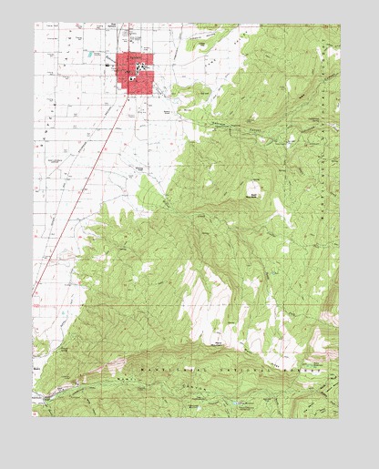
Ephraim, UT USGS Topographic Map
Click on map above to begin viewing in our Map Viewer.

This topographic map contains these locations and features:
Feature Name Type Latitude Longitude GNIS ID View Map
Bald MountainSummitN39.3200°W111.5341°1438355View Map
Bald Mountain Wildlife Management AreaParkN39.3294°W111.5424°1448104View Map
Birch CanyonValleyN39.2589°W111.6049°1438780View Map
Cane ValleyValleyN39.3583°W111.5674°1439463View Map
Cane Valley DitchCanalN39.3555°W111.5482°1439464View Map
City of EphraimCivilN39.3577°W111.5819°2410449View Map
Cottonwood CreekStreamN39.2564°W111.5560°1440016View Map
Cottonwood CreekStreamN39.3402°W111.5299°1440020View Map
Cottonwood ReservoirReservoirN39.2536°W111.5574°1440032View Map
Cottonwood SpringSpringN39.3438°W111.5094°1440040View Map
EphraimPopulated PlaceN39.3597°W111.5863°1440944View Map
Ephraim Ambulance AssociationBuildingN39.3601°W111.5881°2665446View Map
Ephraim CanyonValleyN39.3444°W111.5635°1440945View Map
Ephraim Canyon State Wildlife Management AreaLocaleN39.3300°W111.5452°1453017View Map
Ephraim CreekStreamN39.3702°W111.6005°1440946View Map
Ephraim Elementary SchoolSchoolN39.3495°W111.5808°1448384View Map
Ephraim Middle SchoolSchoolN39.3504°W111.5829°1448382View Map
Ephraim Park CemeteryCemeteryN39.3716°W111.5874°1448383View Map
Ephraim Police DepartmentBuildingN39.3595°W111.5868°2730354View Map
Ephraim Post OfficePost OfficeN39.3620°W111.5854°1455262View Map
Ephraim Volunteer Fire DepartmentBuildingN39.3484°W111.5836°2627327View Map
Funks CanyonValleyN39.2552°W111.6205°1441257View Map
Gal HillSummitN39.3527°W111.5577°1441260View Map
Guard KnollSummitN39.3464°W111.5694°1441520View Map
Jimmys ForkStreamN39.3102°W111.5457°1442147View Map
KEPH-FM (Ephraim)TowerN39.3736°W111.5757°1455783View Map
Knoll DitchCanalN39.3411°W111.5891°1442347View Map
Limekiln HollowValleyN39.3705°W111.5632°1442613View Map
Little HillSummitN39.3680°W111.5549°1442725View Map
Manti CanyonValleyN39.2566°W111.6235°1443137View Map
Manti Canyon Summer HomesPopulated PlaceN39.2561°W111.5213°1451291View Map
Manti Communtiy CampgroundLocaleN39.2533°W111.5410°1443138View Map
Manti Face Wildlife Management AreaParkN39.2811°W111.5919°1448642View Map
Manti MountainSummitN39.2733°W111.5480°1443139View Map
Manti RidgeRidgeN39.2683°W111.5319°1443140View Map
Manti-Ephraim AirportAirportN39.3280°W111.6149°1447599View Map
Maple CreekStreamN39.3375°W111.5263°1443161View Map
Middle Fork Manti CanyonValleyN39.2589°W111.5096°1443347View Map
Mill HillSummitN39.3472°W111.5646°1443452View Map
New CanyonValleyN39.3433°W111.5202°1443804View Map
North Fork Manti CanyonValleyN39.2586°W111.5096°1443915View Map
Park CemeteryCemeteryN39.3716°W111.5880°1444205View Map
Petes ReservoirReservoirN39.2666°W111.5116°1444319View Map
Power House CanalCanalN39.2589°W111.6030°1444623View Map
Quarry Field CanalCanalN39.2883°W111.6080°1444693View Map
Sanpete CountyCivilN39.3739°W111.5764°1448033View Map
Sanpete District Ranger OfficeLocaleN39.3577°W111.5880°1449992View Map
Snow CollegeSchoolN39.3611°W111.5815°1445738View Map
Snow College Field StationSchoolN39.3689°W111.5860°1445739View Map
Snow College Police DepartmentBuildingN39.3620°W111.5832°2730478View Map
South Fork Manti CanyonValleyN39.2580°W111.5280°1445857View Map
South Fork Willow CreekStreamN39.3102°W111.5457°1445887View Map
Temple SpringSpringN39.2719°W111.6143°1446388View Map
The BenchBenchN39.2508°W111.5152°1446415View Map
The Church of Jesus Christ of Latter Day SaintsChurchN39.3605°W111.5844°1450967View Map
The Church of Jesus Christ of Latter Day SaintsChurchN39.3594°W111.5877°1450741View Map
The Church of Jesus Christ of Latter Day SaintsChurchN39.3619°W111.5835°1450742View Map
The Church of Jesus Christ of Latter Day SaintsChurchN39.3564°W111.5838°1450743View Map
The CottonwoodsWoodsN39.2555°W111.5585°1446429View Map
United States Forest Service Fire Station - Ephraim OfficeBuildingN39.3708°W111.5863°2768494View Map
White Ledge ForkStreamN39.3430°W111.5032°1447258View Map
Willow CreekStreamN39.3275°W111.5966°1447403View Map
Witches KnollSummitN39.3283°W111.5805°1447492View Map
Yearns ReservoirReservoirN39.2546°W111.5430°1447549View Map
Yearns Reservoir DamDamN39.2550°W111.5441°1447780View Map

Note: Coordinates in the location and feature list above are referenced to NAD83 datum.


Copyright (C) 2008-2025 Ryan Niemi / Sunset Dynamics ... All Rights Reserved