TopoQuest Logo
Do you find TopoQuest useful?
Help keep TopoQuest running and adding new maps/features by donating!
Bitcoin:  19c7KJd3qBynnjoSw5npx9KScwjBe4ifkT
Litecoin:  LXs6TkuXGGXo1vDsWCkWVdjQX94eUKd6ui
Home View Maps Find Maps Find Places Resources & Links


Wales, Utah Topographic Map

USGS Map Title: Wales, UT
USGS Map MRC: 39111D6
DRG (GeoTIFF) Download: o39111d6.tif


Neighboring USGS Topographic Map Quads:


  Levan, UT  
39111E7
 

  Fountain Green South, UT  
39111E6
 

  Moroni, UT  
39111E5
 

  Chriss Canyon, UT  
39111D7
 

  Wales, UT  
39111D6
 

  Chester, UT  
39111D5
 

  Hells Kitchen Canyon SE, UT  
39111C7
 

  Manti, UT  
39111C6
 

  Ephraim, UT  
39111C5


Map MRC Location:

N40°
W112°
N40°
W111°
H8 H7 H6 H5 H4 H3 H2 H1
G8 G7 G6 G5 G4 G3 G2 G1
F8 F7 F6 F5 F4 F3 F2 F1
E8 E7 E6 E5 E4 E3 E2 E1
D8 D7 D6 D5 D4 D3 D2 D1
C8 C7 C6 C5 C4 C3 C2 C1
B8 B7 B6 B5 B4 B3 B2 B1
A8 A7 A6 A5 A4 A3 A2 A1
N39°
W112°
N39°
W111°

Wales, UT USGS 1:24K Topographic Map Preview:
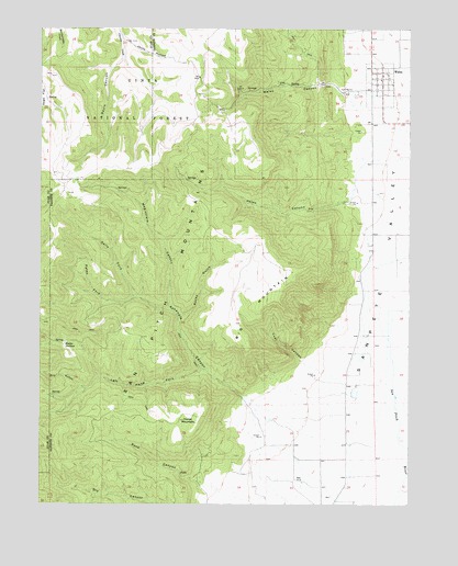
Wales, UT USGS Topographic Map
Click on map above to begin viewing in our Map Viewer.

This topographic map contains these locations and features:
Feature Name Type Latitude Longitude GNIS ID View Map
Ax Handle CanyonValleyN39.4033°W111.6827°1438314View Map
Big MountainSummitN39.4411°W111.6752°1438706View Map
Coal CanyonValleyN39.4122°W111.6621°1439829View Map
Dells ForkStreamN39.4294°W111.7191°1440407View Map
Dry GulchValleyN39.4052°W111.7349°1440634View Map
Horse MountainSummitN39.3980°W111.6966°1441889View Map
Jacks HollowValleyN39.4963°W111.7230°1442087View Map
Left Hand Fork Axhandle CanyonValleyN39.4102°W111.6949°1442546View Map
Magistrate CanyonValleyN39.4263°W111.7063°1443069View Map
Oak CreekStreamN39.3877°W111.6255°1444015View Map
Peach Canyon CreekStreamN39.4433°W111.6383°1451325View Map
Petes CanyonValleyN39.4541°W111.6480°1444313View Map
Petes ForkStreamN39.4283°W111.7283°1444316View Map
Rock CanyonValleyN39.3808°W111.6971°1445036View Map
Rocky GulchValleyN39.4238°W111.7035°1445120View Map
San Pitch MountainsRangeN39.4463°W111.7038°1445298View Map
Sauls CanyonValleyN39.4919°W111.7233°1445343View Map
The Church of Jesus Christ of Latter Day SaintsChurchN39.4866°W111.6358°1449653View Map
Town of WalesCivilN39.4852°W111.6361°2413441View Map
WalesPopulated PlaceN39.4869°W111.6352°1446954View Map
Wales CanyonValleyN39.4836°W111.6466°1446955View Map
Wales CemeteryCemeteryN39.4825°W111.6441°1449154View Map
Wales Volunteer Fire DepartmentBuildingN39.4876°W111.6344°2627397View Map
Water HollowValleyN39.4161°W111.7358°1447050View Map

Note: Coordinates in the location and feature list above are referenced to NAD83 datum.


Copyright (C) 2008-2025 Ryan Niemi / Sunset Dynamics ... All Rights Reserved