TopoQuest Logo
Do you find TopoQuest useful?
Help keep TopoQuest running and adding new maps/features by donating!
Bitcoin:  19c7KJd3qBynnjoSw5npx9KScwjBe4ifkT
Litecoin:  LXs6TkuXGGXo1vDsWCkWVdjQX94eUKd6ui
Home View Maps Find Maps Find Places Resources & Links


Chester, Utah Topographic Map

USGS Map Title: Chester, UT
USGS Map MRC: 39111D5
DRG (GeoTIFF) Download: o39111d5.tif


Neighboring USGS Topographic Map Quads:


  Fountain Green South, UT  
39111E6
 

  Moroni, UT  
39111E5
 

  Mount Pleasant, UT  
39111E4
 

  Wales, UT  
39111D6
 

  Chester, UT  
39111D5
 

  Spring City, UT  
39111D4
 

  Manti, UT  
39111C6
 

  Ephraim, UT  
39111C5
 

  Danish Knoll, UT  
39111C4


Map MRC Location:

N40°
W112°
N40°
W111°
H8 H7 H6 H5 H4 H3 H2 H1
G8 G7 G6 G5 G4 G3 G2 G1
F8 F7 F6 F5 F4 F3 F2 F1
E8 E7 E6 E5 E4 E3 E2 E1
D8 D7 D6 D5 D4 D3 D2 D1
C8 C7 C6 C5 C4 C3 C2 C1
B8 B7 B6 B5 B4 B3 B2 B1
A8 A7 A6 A5 A4 A3 A2 A1
N39°
W112°
N39°
W111°

Chester, UT USGS 1:24K Topographic Map Preview:
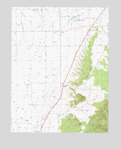
Chester, UT USGS Topographic Map
Click on map above to begin viewing in our Map Viewer.

This topographic map contains these locations and features:
Feature Name Type Latitude Longitude GNIS ID View Map
Bill Allred CreekStreamN39.3922°W111.5580°1438760View Map
Bill Allred DitchCanalN39.3994°W111.5291°1438761View Map
Black HillSummitN39.3830°W111.5382°1438846View Map
Black Hills Wildlife Management AreaParkN39.3805°W111.5424°1448143View Map
Canal CreekStreamN39.4894°W111.5238°1439461View Map
ChesterPopulated PlaceN39.4761°W111.5630°1439662View Map
Chester CemeteryCemeteryN39.4825°W111.5485°1448264View Map
Chester PondsReservoirN39.4887°W111.5472°1439663View Map
Chester Post OfficePost OfficeN39.4652°W111.5724°1455140View Map
Crawford DitchCanalN39.4419°W111.5105°1440138View Map
Ephraim Pioneer CemeteryCemeteryN39.3894°W111.5835°1444441View Map
Gobblefield DitchCanalN39.3819°W111.5649°1441343View Map
Johnson SpringsSpringN39.3869°W111.6066°1442193View Map
Little Pigeon HollowValleyN39.3958°W111.5507°1442760View Map
Lower Chimney DitchCanalN39.4911°W111.5524°1443005View Map
McKinley Strates DamDamN39.4772°W111.5113°1447797View Map
McKinley Strates ReservoirReservoirN39.4771°W111.5129°1447796View Map
Olafs PondReservoirN39.3886°W111.6134°1444063View Map
Pigeon CreekStreamN39.3900°W111.5810°1444348View Map
Pigeon HollowValleyN39.4227°W111.5571°1444350View Map
Pigeon Hollow JunctionPopulated PlaceN39.4216°W111.5591°1444351View Map
Rock Dam CanalCanalN39.4947°W111.5924°1445067View Map
Sand RidgeRidgeN39.4111°W111.5730°1445313View Map
Silver CreekStreamN39.4764°W111.5994°1445590View Map
Silver Creek DitchCanalN39.4702°W111.6121°1445592View Map
Spring City CemeteryCemeteryN39.4802°W111.5157°1445993View Map
Spring City Wildlife Management AreaParkN39.4333°W111.5249°1449047View Map
Spring DitchCanalN39.4955°W111.5657°1446029View Map
The Canal DitchCanalN39.4941°W111.5691°1446422View Map
Upper Chimney DitchCanalN39.4966°W111.5444°1446857View Map
West EphraimPopulated PlaceN39.3755°W111.5891°1447124View Map
White HillSummitN39.4091°W111.5338°1447248View Map

Note: Coordinates in the location and feature list above are referenced to NAD83 datum.


Copyright (C) 2008-2024 Ryan Niemi / Sunset Dynamics ... All Rights Reserved