TopoQuest Logo
Do you find TopoQuest useful?
Help keep TopoQuest running and adding new maps/features by donating!
Bitcoin:  19c7KJd3qBynnjoSw5npx9KScwjBe4ifkT
Litecoin:  LXs6TkuXGGXo1vDsWCkWVdjQX94eUKd6ui
Home View Maps Find Maps Find Places Resources & Links


Marcella, Arkansas Topographic Map

USGS Map Title: Marcella, AR
USGS Map MRC: 35091G8
DRG (GeoTIFF) Download: o35091g8.tif


Neighboring USGS Topographic Map Quads:


  Sylamore, AR  
35092H1
 

  Guion, AR  
35091H8
 

  Mount Pleasant, AR  
35091H7
 

  Mountain View, AR  
35092G1
 

  Marcella, AR  
35091G8
 

  Bethesda, AR  
35091G7
 

  Prim, AR  
35092F1
 

  Drasco, AR  
35091F8
 

  Concord, AR  
35091F7


Map MRC Location:

N36°
W92°
N36°
W91°
H8 H7 H6 H5 H4 H3 H2 H1
G8 G7 G6 G5 G4 G3 G2 G1
F8 F7 F6 F5 F4 F3 F2 F1
E8 E7 E6 E5 E4 E3 E2 E1
D8 D7 D6 D5 D4 D3 D2 D1
C8 C7 C6 C5 C4 C3 C2 C1
B8 B7 B6 B5 B4 B3 B2 B1
A8 A7 A6 A5 A4 A3 A2 A1
N35°
W92°
N35°
W91°

Marcella, AR USGS 1:24K Topographic Map Preview:
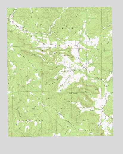
Marcella, AR USGS Topographic Map
Click on map above to begin viewing in our Map Viewer.

This topographic map contains these locations and features:
Feature Name Type Latitude Longitude GNIS ID View Map
6th District Fire DepartmentBuildingN35.8168°W91.9088°2116055View Map
Alder CreekStreamN35.8112°W91.8760°45806View Map
Arbanna Baptist ChurchChurchN35.7876°W91.9640°76185View Map
Bluetip (historical)Populated PlaceN35.7542°W91.9171°65824View Map
Burton HillSummitN35.8487°W91.9210°57476View Map
Cave PointSummitN35.8329°W91.9290°57530View Map
Chalybeate Spring CreekStreamN35.7762°W91.9899°47673View Map
Chalybeate SpringsSpringN35.7780°W91.9681°68713View Map
Chalybeate SpringsPopulated PlaceN35.7804°W91.9582°76583View Map
Conditt HollowValleyN35.7842°W91.8960°47957View Map
Cookfield BranchStreamN35.8262°W91.8915°47982View Map
Davis LakeReservoirN35.8268°W91.9175°80976View Map
Davis MountainSummitN35.7909°W91.9249°48395View Map
Dry HollowValleyN35.8659°W91.9304°48664View Map
Dugan CemeteryCemeteryN35.8501°W91.9671°48684View Map
Dugan ChurchChurchN35.8573°W91.9876°48685View Map
Fortune PointCliffN35.7740°W91.9943°49184View Map
Foster HollowValleyN35.8490°W91.9585°49195View Map
Haney HollowValleyN35.8148°W91.9246°49820View Map
Haywood CemeteryCemeteryN35.7534°W91.9035°49968View Map
Hub Chute HollowValleyN35.7779°W91.9101°50372View Map
Hurricane HollowValleyN35.8167°W91.9265°50457View Map
Hyte CemeteryCemeteryN35.7981°W91.8838°50479View Map
Iron Mountain Volunteer Fire StationBuildingN35.8059°W91.9959°2116621View Map
J I Davis Lake DamDamN35.8251°W91.9168°80975View Map
Kahoka (historical)Populated PlaceN35.7965°W91.9946°65831View Map
Kelly and Ford CemeteryCemeteryN35.8420°W91.9138°50794View Map
Kirkland CreekStreamN35.7748°W91.8857°50884View Map
Knights CoveValleyN35.7981°W91.9385°50896View Map
Knights Cove CreekStreamN35.8131°W91.9185°50897View Map
KWOZ-FM (Mountain View)TowerN35.7851°W91.9624°85232View Map
Logan PointCliffN35.8151°W91.9435°51391View Map
MarcellaPopulated PlaceN35.7881°W91.8838°58122View Map
Marcella Post OfficePost OfficeN35.7904°W91.8843°84340View Map
Massey CreekStreamN35.8712°W91.9321°51737View Map
McGee PointCliffN35.8073°W91.9374°51838View Map
Mennonite ChurchChurchN35.7715°W91.9401°65836View Map
Mill HollowValleyN35.8517°W91.9485°52036View Map
Miller MountainSummitN35.8287°W91.9501°58187View Map
Mount Joy ChurchChurchN35.8615°W91.9946°52310View Map
Mundy PointSummitN35.7948°W91.8968°52547View Map
Owl HollowValleyN35.7776°W91.9101°53112View Map
Pine HillSummitN35.8681°W91.9643°53433View Map
Pleasant GrovePopulated PlaceN35.8165°W91.9093°78030View Map
Pleasant Grove Fire and RescueBuildingN35.8237°W91.9148°2119176View Map
Pleasant Grove Post OfficePost OfficeN35.8172°W91.9100°84343View Map
Pruitt PointSummitN35.8267°W91.9229°58441View Map
Saint JamesPopulated PlaceN35.8384°W91.9179°58570View Map
Steam Mill BranchStreamN35.8181°W91.8965°78453View Map
Tater HillSummitN35.8590°W91.9615°58733View Map
Taylor PointCliffN35.7662°W91.9032°55476View Map
Township of ArbanaCivilN35.7961°W91.9983°2406937View Map
Township of FranklinCivilN35.8615°W91.9208°69723View Map
Township of Red StripeCivilN35.8167°W91.9186°69732View Map
Township of Wallace (historical)CivilN35.7765°W91.9113°69740View Map
Tuttle RidgeRidgeN35.7595°W91.9904°55751View Map

Note: Coordinates in the location and feature list above are referenced to NAD83 datum.


Copyright (C) 2008-2024 Ryan Niemi / Sunset Dynamics ... All Rights Reserved