TopoQuest Logo
Do you find TopoQuest useful?
Help keep TopoQuest running and adding new maps/features by donating!
Bitcoin:  19c7KJd3qBynnjoSw5npx9KScwjBe4ifkT
Litecoin:  LXs6TkuXGGXo1vDsWCkWVdjQX94eUKd6ui
Home View Maps Find Maps Find Places Resources & Links


Guion, Arkansas Topographic Map

USGS Map Title: Guion, AR
USGS Map MRC: 35091H8
DRG (GeoTIFF) Download: o35091h8.tif


Neighboring USGS Topographic Map Quads:


  Boswell, AR  
36092A1
 

  Melbourne, AR  
36091A8
 

  Zion, AR  
36091A7
 

  Sylamore, AR  
35092H1
 

  Guion, AR  
35091H8
 

  Mount Pleasant, AR  
35091H7
 

  Mountain View, AR  
35092G1
 

  Marcella, AR  
35091G8
 

  Bethesda, AR  
35091G7


Map MRC Location:

N36°
W92°
N36°
W91°
H8 H7 H6 H5 H4 H3 H2 H1
G8 G7 G6 G5 G4 G3 G2 G1
F8 F7 F6 F5 F4 F3 F2 F1
E8 E7 E6 E5 E4 E3 E2 E1
D8 D7 D6 D5 D4 D3 D2 D1
C8 C7 C6 C5 C4 C3 C2 C1
B8 B7 B6 B5 B4 B3 B2 B1
A8 A7 A6 A5 A4 A3 A2 A1
N35°
W92°
N35°
W91°

Guion, AR USGS 1:24K Topographic Map Preview:
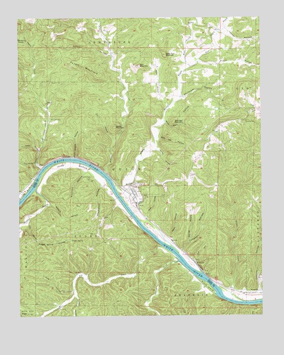
Guion, AR USGS Topographic Map
Click on map above to begin viewing in our Map Viewer.

This topographic map contains these locations and features:
Feature Name Type Latitude Longitude GNIS ID View Map
A T Foster ProspectMineN35.9062°W91.9404°81627View Map
Alex Fults ProspectMineN35.8870°W91.9565°81628View Map
Arnold HollowValleyN35.9848°W91.9526°45937View Map
Bear Spring HollowValleyN35.9903°W91.9960°70576View Map
Beckman HollowValleyN35.9373°W91.9632°46285View Map
Brothers SpurLocaleN35.9376°W91.9876°81539View Map
Byler BranchStreamN35.9631°W91.9224°47253View Map
Cagens CreekStreamN35.8981°W91.9179°76491View Map
Campbell CemeteryCemeteryN35.9340°W91.9118°47345View Map
Campbell HollowValleyN35.9015°W91.9168°47350View Map
Cave HollowValleyN35.9156°W91.9951°47545View Map
Cave SpringSpringN35.9392°W91.9929°47552View Map
Cypert MountainSummitN35.9812°W91.9743°48288View Map
Dry CreekStreamN35.9031°W91.9246°48646View Map
Dugger SpringSpringN35.9068°W91.9732°48690View Map
Dugger Spring HollowValleyN35.9062°W91.9901°48692View Map
East Rocky BayouStreamN35.9798°W91.9113°48776View Map
Fort MountainSummitN35.9798°W91.9379°49178View Map
Fulk HollowValleyN35.8862°W91.9718°49284View Map
G F Fults ProspectMineN35.9192°W91.9524°81629View Map
George HollowValleyN35.9059°W91.9118°49373View Map
GuionPopulated PlaceN35.9254°W91.9407°77083View Map
Guion ParkParkN35.9320°W91.9515°49702View Map
Guion Volunteer Fire DepartmentBuildingN35.9249°W91.9400°2116516View Map
Haley Fort MountainSummitN35.9845°W91.9243°49769View Map
Halsey HollowValleyN35.9448°W91.9285°49792View Map
Harper HollowValleyN35.9445°W91.9899°71914View Map
Helm HollowValleyN35.9037°W91.9201°49997View Map
Hidden CreekStreamN35.9340°W91.9540°50090View Map
Jones BottomBendN35.9384°W91.9738°50711View Map
Jones Bottom CemeteryCemeteryN35.9340°W91.9626°50712View Map
Lafferty HollowValleyN35.8831°W91.8751°50937View Map
Lyons CreekStreamN35.9367°W91.9882°72524View Map
Lyons Creek CemeteryCemeteryN35.9576°W91.9838°51530View Map
Massey HollowValleyN35.8837°W91.9713°51738View Map
McCormick CemeteryCemeteryN35.9731°W91.9835°51803View Map
Meeks MountainSummitN35.9540°W91.9513°58160View Map
Mike HollowValleyN35.9148°W91.9357°51954View Map
Moffett HollowValleyN35.9220°W91.9840°52129View Map
MyersvillePopulated PlaceN35.8851°W91.8763°81881View Map
NascoPopulated PlaceN35.9642°W91.9852°57134View Map
Pentecost HollowValleyN35.9670°W91.9160°53275View Map
Pratt CemeteryCemeteryN35.9915°W91.9043°53778View Map
Pruitt HollowValleyN35.9823°W91.9068°53833View Map
Pruitt IslandIslandN35.8876°W91.9032°53834View Map
Rock Castle HollowValleyN35.9415°W91.9710°54085View Map
Rocky BayouStreamN35.9287°W91.9915°73353View Map
Rocky BayouStreamN35.9204°W91.9435°78203View Map
Sam Lee HollowValleyN35.9495°W91.9299°54526View Map
Schoolhouse HollowValleyN35.9265°W91.9968°73493View Map
Tanner HollowValleyN35.9953°W91.8926°55425View Map
Tee BranchStreamN35.9490°W91.9501°55482View Map
Thompson HollowValleyN35.9298°W91.9535°55547View Map
Town of GuionCivilN35.9271°W91.9385°2406626View Map
Township of GuionCivilN35.9436°W91.9418°66701View Map
Township of JonesCivilN35.9072°W91.9669°69727View Map
West Rocky BayouStreamN35.9798°W91.9113°56199View Map
Wilson CreekStreamN35.8804°W91.8838°56441View Map
Wolf Den HollowValleyN35.9567°W91.9246°56490View Map
Wolf Den MountainSummitN35.9565°W91.9201°56491View Map
WolquarryPopulated PlaceN35.8976°W91.9096°58906View Map

Note: Coordinates in the location and feature list above are referenced to NAD83 datum.


Copyright (C) 2008-2024 Ryan Niemi / Sunset Dynamics ... All Rights Reserved