TopoQuest Logo
Do you find TopoQuest useful?
Help keep TopoQuest running and adding new maps/features by donating!
Bitcoin:  19c7KJd3qBynnjoSw5npx9KScwjBe4ifkT
Litecoin:  LXs6TkuXGGXo1vDsWCkWVdjQX94eUKd6ui
Home View Maps Find Maps Find Places Resources & Links


Mount Pleasant, Arkansas Topographic Map

USGS Map Title: Mount Pleasant, AR
USGS Map MRC: 35091H7
DRG (GeoTIFF) Download: o35091h7.tif


Neighboring USGS Topographic Map Quads:


  Melbourne, AR  
36091A8
 

  Zion, AR  
36091A7
 

  Sidney, AR  
36091A6
 

  Guion, AR  
35091H8
 

  Mount Pleasant, AR  
35091H7
 

  Sandtown, AR  
35091H6
 

  Marcella, AR  
35091G8
 

  Bethesda, AR  
35091G7
 

  Batesville, AR  
35091G6


Map MRC Location:

N36°
W92°
N36°
W91°
H8 H7 H6 H5 H4 H3 H2 H1
G8 G7 G6 G5 G4 G3 G2 G1
F8 F7 F6 F5 F4 F3 F2 F1
E8 E7 E6 E5 E4 E3 E2 E1
D8 D7 D6 D5 D4 D3 D2 D1
C8 C7 C6 C5 C4 C3 C2 C1
B8 B7 B6 B5 B4 B3 B2 B1
A8 A7 A6 A5 A4 A3 A2 A1
N35°
W92°
N35°
W91°

Mount Pleasant, AR USGS 1:24K Topographic Map Preview:
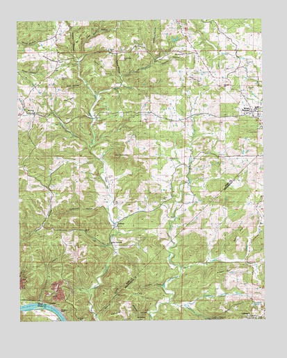
Mount Pleasant, AR USGS Topographic Map
Click on map above to begin viewing in our Map Viewer.

This topographic map contains these locations and features:
Feature Name Type Latitude Longitude GNIS ID View Map
Adeline HillSummitN35.8770°W91.8268°57248View Map
Adler HollowValleyN35.9048°W91.8257°45795View Map
Adler Hollow MineMineN35.8995°W91.8179°81533View Map
Anderson ProspectMineN35.9576°W91.7613°81534View Map
Bailey Brooks BranchStreamN35.9467°W91.8382°46009View Map
Barksdale MineMineN35.9140°W91.8238°81535View Map
Bat Knob HillSummitN35.9945°W91.8440°57338View Map
Bevans ProspectMineN35.9529°W91.7896°81536View Map
Blowing Cave CreekStreamN35.8829°W91.7990°46732View Map
Blowing Cave SpringSpringN35.8754°W91.7738°81400View Map
Bob Wilson ProspectMineN35.8951°W91.7649°81401View Map
Breeden ProspectMineN35.8842°W91.8485°81538View Map
Brown CreekStreamN35.9687°W91.8349°47005View Map
Bryant HollowValleyN35.9862°W91.8468°47105View Map
Buckalew HillSummitN35.9842°W91.8218°47139View Map
C L Sanders ProspectMineN35.9151°W91.8357°81540View Map
Calaway ProspectMineN35.8890°W91.7907°81409View Map
Caraway ProspectMineN35.9195°W91.8118°81541View Map
Cave Hill MineMineN35.9284°W91.8126°81542View Map
Cedar Grove School (historical)SchoolN35.9440°W91.7840°56804View Map
Chappel HollowValleyN35.9715°W91.8074°47704View Map
Chinquapin CemeteryCemeteryN35.9817°W91.7585°56802View Map
Clark HillSummitN35.8854°W91.8188°57552View Map
Clubhouse Extension Mines (historical)MineN35.8779°W91.7621°81848View Map
Clubhouse MineMineN35.8817°W91.7576°81849View Map
Clubhouse SpringSpringN35.8806°W91.7563°47864View Map
Clubhouse Spring BranchStreamN35.8817°W91.7907°47865View Map
Colley BranchStreamN35.9840°W91.8443°47928View Map
Craig HillSummitN35.9973°W91.7979°57598View Map
CrockerPopulated PlaceN35.8829°W91.8615°76708View Map
Crosby HollowValleyN35.8887°W91.8018°48185View Map
Cummins HollowValleyN35.8937°W91.8360°81543View Map
Cummins Hollow MineMineN35.8954°W91.8371°81544View Map
Cutter MineMineN35.8945°W91.8115°81417View Map
Dan HollowValleyN35.9815°W91.8249°48347View Map
Dilliner HollowValleyN35.9820°W91.8068°48519View Map
E D Winkle ProspectMineN35.9145°W91.8335°81545View Map
E Winkle ProspectMineN35.9531°W91.7526°81546View Map
Earl Collie MineMineN35.9131°W91.8224°81547View Map
Edmonson (historical)Populated PlaceN35.8912°W91.8163°57702View Map
Edwards MineMineN35.8842°W91.8076°81425View Map
Egard HillSummitN35.9828°W91.8338°57704View Map
Egard HollowValleyN35.9770°W91.8226°48824View Map
Ellen Clark ProspectMineN35.8895°W91.8115°81427View Map
Felts ProspectMineN35.8829°W91.7557°81428View Map
Fulbright HillSummitN35.9742°W91.7838°49283View Map
GidPopulated PlaceN35.9798°W91.8565°57031View Map
Gid SchoolSchoolN35.9765°W91.8560°49400View Map
Groove HollowValleyN35.9151°W91.7521°49688View Map
H J Ray ProspectMineN35.9467°W91.8046°81548View Map
H M Tate ProspectMineN35.9001°W91.8471°81549View Map
Haddock ProspectMineN35.9495°W91.7649°81550View Map
Hall ProspectMineN35.9587°W91.7690°81551View Map
Hankins HollowValleyN35.8765°W91.8357°49823View Map
Hankins Hollow MineMineN35.8792°W91.8338°81439View Map
Hassel CemeteryCemeteryN35.9087°W91.8363°56898View Map
Helm ProspectMineN35.9145°W91.8418°81552View Map
Hollawell ProspectMineN35.9515°W91.7524°81554View Map
Izard County Christian SchoolSchoolN35.9606°W91.7596°56897View Map
Izard MineMineN35.8987°W91.8176°81555View Map
J P Barnes ProspectMineN35.9048°W91.7660°81449View Map
J R Dobson ProspectMineN35.9237°W91.7621°81450View Map
Jeff HillSummitN35.9870°W91.8043°57983View Map
Johnson Hill MineMineN35.9009°W91.8321°81556View Map
Klondike MineMineN35.9495°W91.7626°81557View Map
L B Ray ProspectMineN35.9587°W91.7729°81558View Map
L J Weaver MineMineN35.9320°W91.8118°81559View Map
LaffertyPopulated PlaceN35.9142°W91.8251°77428View Map
Lafferty Community ChurchChurchN35.9070°W91.8288°56899View Map
Lafferty School (historical)SchoolN35.9034°W91.8271°56813View Map
Lewis ProspectMineN35.9320°W91.8138°81560View Map
Love HollowValleyN35.8826°W91.8640°51485View Map
Love ProspectMineN35.8973°W91.8604°81561View Map
M E Wilson ProspectMineN35.9523°W91.7910°81562View Map
Macedonia ChurchChurchN35.9853°W91.7899°56894View Map
Macedonia CreekStreamN35.9731°W91.8224°51582View Map
Macedonia HollowValleyN35.9845°W91.8057°51583View Map
Macedonia School (historical)SchoolN35.9831°W91.8060°56815View Map
Manganese Field MineMineN35.9148°W91.8101°81564View Map
McConnell MineMineN35.9292°W91.7715°81563View Map
Miller ProspectMineN35.8926°W91.7835°81468View Map
Moser CemeteryCemeteryN35.9426°W91.7987°56818View Map
Moser HollowValleyN35.9715°W91.8074°56819View Map
Moser ProspectMineN35.9540°W91.7685°81565View Map
Mount EtnaSummitN35.9117°W91.7618°58221View Map
Mount Etna MineMineN35.9173°W91.7563°81473View Map
Mount Etna School (historical)SchoolN35.9187°W91.7563°56820View Map
Mount Lebanon ChurchChurchN35.9701°W91.8629°52312View Map
Mount PleasantPopulated PlaceN35.9617°W91.7557°77734View Map
Mount Pleasant Elementary SchoolSchoolN35.9631°W91.7523°65888View Map
Mount Pleasant Fire DepartmentBuildingN35.9629°W91.7565°2116822View Map
Mount Pleasant High SchoolSchoolN35.9629°W91.7535°65889View Map
Mount Pleasant Post OfficePost OfficeN35.9612°W91.7540°2781934View Map
Mount Pleasant Public SchoolsSchoolN35.9628°W91.7538°56900View Map
Nail CemeteryCemeteryN35.9217°W91.7990°52570View Map
Negro HillSummitN35.9915°W91.8235°52775View Map
Neill ProspectMineN35.9062°W91.7874°81475View Map
New Home ChurchChurchN35.9620°W91.8668°52650View Map
No Bottom CemeteryCemeteryN35.9773°W91.8271°52784View Map
O'Gilsby ProspectMineN35.9615°W91.7699°81566View Map
Page MineMineN35.8862°W91.7518°81478View Map
Painters BluffCliffN35.8801°W91.8526°56827View Map
Palmer HollowValleyN35.9179°W91.7518°53140View Map
Pine Grove HollowValleyN35.9840°W91.8443°53432View Map
Pine MountainSummitN35.9429°W91.8235°53458View Map
Pittman MinesMineN35.8834°W91.8299°81568View Map
Pugh MineMineN35.8995°W91.8232°81569View Map
Pumpkin CreekStreamN35.8962°W91.7929°78118View Map
Ray CemeteryCemeteryN35.9237°W91.8263°53919View Map
Reeves HillSummitN35.9762°W91.8532°58480View Map
Rinn CemeteryCemeteryN35.8898°W91.7590°54046View Map
Rout HillSummitN35.9676°W91.8490°58550View Map
Rout HollowValleyN35.9745°W91.8410°54254View Map
Rudolph ProspectMineN35.9687°W91.7574°81570View Map
Ruminer Rough MineMineN35.9154°W91.8171°81571View Map
Salt Peter Hill MineMineN35.8826°W91.8076°81493View Map
Saltpeter HillSummitN35.8756°W91.8140°81896View Map
Saltpeter HollowValleyN35.8779°W91.8096°81897View Map
Sand Field MineMineN35.9126°W91.8101°81572View Map
Sand Field ProspectMineN35.8787°W91.8004°81494View Map
Sanders ProspectMineN35.8915°W91.7851°81495View Map
Shaw HillSummitN35.9715°W91.7574°58608View Map
Sheffield HollowValleyN35.9845°W91.8057°54753View Map
Skelton Hill MineMineN35.8917°W91.8274°81575View Map
Skelton-Hanford ProspectMineN35.8834°W91.8426°81574View Map
Spring Valley Ranch Landing Strip (historical)AirportN35.9326°W91.8301°56896View Map
Standing RocksSummitN35.9837°W91.8543°55151View Map
Sterrett MineMineN35.8898°W91.7849°81512View Map
Stewart HillSummitN35.8940°W91.7768°58689View Map
Stillhouse HollowValleyN35.9217°W91.8301°55229View Map
T C Winkle ProspectMineN35.9442°W91.8326°81576View Map
T M Tate MineMineN35.8779°W91.8354°81514View Map
Town of Mount PleasantCivilN35.9817°W91.7763°2406210View Map
Township of DrytownCivilN35.9716°W91.7969°66698View Map
Township of GidCivilN35.9843°W91.8564°66700View Map
Township of LaffertyCivilN35.9134°W91.8491°66705View Map
Township of Union (historical)CivilN35.8876°W91.7668°68781View Map
Turner CreekStreamN35.8990°W91.7629°55743View Map
Verna MineMineN35.8981°W91.8246°81577View Map
W A King MineMineN35.9534°W91.7513°81578View Map
W K Tate ProspectMineN35.9092°W91.8501°81579View Map
W L Johnson ProspectMineN35.8940°W91.7718°81521View Map
Waterfall HollowValleyN35.9615°W91.8704°56091View Map
Williamson-Gulley ProspectMineN35.8967°W91.8721°81580View Map
Winkle CemeteryCemeteryN35.9353°W91.8299°56838View Map
Wolford MineMineN35.9079°W91.7849°81529View Map
Younger HillSummitN35.9723°W91.7704°56617View Map

Note: Coordinates in the location and feature list above are referenced to NAD83 datum.


Copyright (C) 2008-2025 Ryan Niemi / Sunset Dynamics ... All Rights Reserved