TopoQuest Logo
Do you find TopoQuest useful?
Help keep TopoQuest running and adding new maps/features by donating!
Bitcoin:  19c7KJd3qBynnjoSw5npx9KScwjBe4ifkT
Litecoin:  LXs6TkuXGGXo1vDsWCkWVdjQX94eUKd6ui
Home View Maps Find Maps Find Places Resources & Links


Wright, Alabama Topographic Map

USGS Map Title: Wright, AL
USGS Map MRC: 34087H8
DRG (GeoTIFF) Download: o34087h8.tif


Neighboring USGS Topographic Map Quads:


  Lowryville, TN  
35088A1
 

  Ransom Stand, TN  
35087A8
 

  Cypress Inn, TN  
35087A7
 

  Waterloo, AL  
34088H1
 

  Wright, AL  
34087H8
 

  Threet, AL  
34087H7
 

  Margerum, AL  
34088G1
 

  Cherokee, AL  
34087G8
 

  Sinking Creek, AL  
34087G7


Map MRC Location:

N35°
W88°
N35°
W87°
H8 H7 H6 H5 H4 H3 H2 H1
G8 G7 G6 G5 G4 G3 G2 G1
F8 F7 F6 F5 F4 F3 F2 F1
E8 E7 E6 E5 E4 E3 E2 E1
D8 D7 D6 D5 D4 D3 D2 D1
C8 C7 C6 C5 C4 C3 C2 C1
B8 B7 B6 B5 B4 B3 B2 B1
A8 A7 A6 A5 A4 A3 A2 A1
N34°
W88°
N34°
W87°

Wright, AL USGS 1:24K Topographic Map Preview:
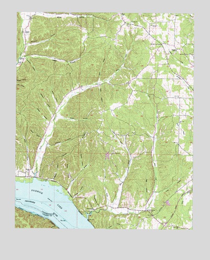
Wright, AL USGS Topographic Map
Click on map above to begin viewing in our Map Viewer.

This topographic map contains these locations and features:
Feature Name Type Latitude Longitude GNIS ID View Map
Barton BranchStreamN34.9062°W87.9864°113525View Map
Baskens HollowValleyN34.9397°W87.9733°113549View Map
Beckham HollowValleyN34.9809°W87.9935°113781View Map
Bitter BranchStreamN34.8854°W87.9325°114390View Map
Bluff CreekStreamN34.8806°W87.9495°114608View Map
Bluff Creek HillSummitN34.8820°W87.9083°145076View Map
Boiling Spring HollowValleyN34.8861°W87.9441°114699View Map
Browns Store (historical)LocaleN34.9959°W87.9906°145085View Map
Brush CreekStreamN34.9037°W87.9864°115040View Map
Brush Creek Island (historical)IslandN34.8870°W87.9842°145087View Map
Brush Creek ParkParkN34.9031°W87.9917°148822View Map
Carrolls Mill (historical)LocaleN34.9176°W87.9131°145099View Map
Crusoe Island (historical)IslandN34.9945°W87.9242°164209View Map
Dabney School (historical)SchoolN34.9931°W87.9209°145137View Map
DartPopulated PlaceN34.9945°W87.9236°166178View Map
Dart Post Office (historical)Post OfficeN34.9945°W87.9236°169255View Map
Dry BranchStreamN34.8859°W87.9350°117511View Map
Dump HollowValleyN34.8921°W87.9601°117647View Map
First United Pentecostal ChurchChurchN34.9087°W87.9911°163823View Map
Fowler BranchStreamN34.8759°W87.8753°118566View Map
Francis-King-Lucas CemeteryCemeteryN34.9965°W87.8834°163825View Map
Gooch HollowValleyN34.9355°W87.9766°119104View Map
Graham School (historical)SchoolN34.9523°W87.9036°145207View Map
Gravelly SpringsPopulated PlaceN34.8859°W87.9081°157970View Map
Gravelly SpringsSpringN34.8854°W87.9081°145209View Map
Gravelly Springs Missionary Baptist ChurchChurchN34.8848°W87.9036°145210View Map
Jones School (historical)SchoolN34.9868°W87.9506°145240View Map
Kendall School (historical)SchoolN34.9765°W87.8759°145242View Map
Kendell (historical)Populated PlaceN34.9765°W87.8817°145243View Map
Lambs Chapel Freewill Baptist ChurchChurchN34.9270°W87.9814°157356View Map
Landrum HollowValleyN34.9237°W87.9784°121367View Map
Landrum HollowValleyN34.9735°W87.9928°121368View Map
Lester HollowValleyN34.9742°W87.9948°152022View Map
Lewis HollowValleyN34.8961°W87.9006°121519View Map
Lindsey BranchStreamN34.9220°W87.9234°121662View Map
Long BranchStreamN34.8979°W87.9673°121992View Map
Long Branch CrossingLocaleN34.8965°W87.9642°142091View Map
Melton HollowValleyN34.9029°W87.9734°152298View Map
Menton HollowValleyN34.9093°W87.9524°122657View Map
Milford CemeteryCemeteryN34.9292°W87.9139°163829View Map
Millsbury Landing (historical)LocaleN34.8920°W87.9884°142103View Map
Murphy ChapelChurchN34.9784°W87.8875°152570View Map
Murphy Cross RoadsPopulated PlaceN34.9820°W87.8981°156760View Map
Oak Grove CemeteryCemeteryN34.9181°W87.9320°141150View Map
Oak Grove ChurchChurchN34.9187°W87.9325°152742View Map
Pettipoole HillSummitN34.9094°W87.9764°142150View Map
Pigeon BranchStreamN34.9595°W87.9442°124712View Map
Pitts HollowValleyN34.9582°W87.9419°124923View Map
Rainbow RidgeRidgeN34.9487°W87.9487°142160View Map
Sego School (historical)SchoolN34.9845°W87.9934°142183View Map
Shady BranchStreamN34.8765°W87.9711°153378View Map
Sharp CemeteryCemeteryN34.9584°W87.9417°126636View Map
Sharps HollowValleyN34.9273°W87.9811°126645View Map
Sigh HollowValleyN34.8904°W87.9069°126834View Map
Smith HollowValleyN34.9020°W87.9603°127025View Map
Smith HollowValleyN34.9399°W87.9698°127026View Map
Spain HollowValleyN34.9454°W87.9702°127158View Map
Texas RidgeRidgeN34.9271°W87.9530°127782View Map
Troublesome Hollow BranchStreamN34.9737°W87.9973°142230View Map
Tumleys Tanyards (historical)LocaleN34.9187°W87.9195°142231View Map
Waterloo Volunteer Fire and Rescue Department Station 2BuildingN34.9036°W87.9811°2682932View Map
Waterloo Volunteer Fire and Rescue Department Station 3BuildingN34.9781°W87.9941°2682946View Map
Williams Chapel United Presbyterian ChurchChurchN34.9884°W87.9950°153993View Map
Woods School (historical)SchoolN34.9587°W87.9403°157355View Map
WrightPopulated PlaceN34.9087°W87.9900°154037View Map
Wrights Landing (historical)LocaleN34.8926°W87.9939°163263View Map
Youngs ChurchChurchN34.9951°W87.9203°154056View Map

Note: Coordinates in the location and feature list above are referenced to NAD83 datum.


Copyright (C) 2008-2025 Ryan Niemi / Sunset Dynamics ... All Rights Reserved