TopoQuest Logo
Do you find TopoQuest useful?
Help keep TopoQuest running and adding new maps/features by donating!
Bitcoin:  19c7KJd3qBynnjoSw5npx9KScwjBe4ifkT
Litecoin:  LXs6TkuXGGXo1vDsWCkWVdjQX94eUKd6ui
Home View Maps Find Maps Find Places Resources & Links


Waterloo, Alabama Topographic Map

USGS Map Title: Waterloo, AL
USGS Map MRC: 34088H1
DRG (GeoTIFF) Download: o34088h1.tif


Neighboring USGS Topographic Map Quads:


  Pickwick, TN  
35088A2
 

  Lowryville, TN  
35088A1
 

  Ransom Stand, TN  
35087A8
 

  Yellow Creek, MS  
34088H2
 

  Waterloo, AL  
34088H1
 

  Wright, AL  
34087H8
 

  Iuka, MS  
34088G2
 

  Margerum, AL  
34088G1
 

  Cherokee, AL  
34087G8


Map MRC Location:

N35°
W89°
N35°
W88°
H8 H7 H6 H5 H4 H3 H2 H1
G8 G7 G6 G5 G4 G3 G2 G1
F8 F7 F6 F5 F4 F3 F2 F1
E8 E7 E6 E5 E4 E3 E2 E1
D8 D7 D6 D5 D4 D3 D2 D1
C8 C7 C6 C5 C4 C3 C2 C1
B8 B7 B6 B5 B4 B3 B2 B1
A8 A7 A6 A5 A4 A3 A2 A1
N34°
W89°
N34°
W88°

Waterloo, AL USGS 1:24K Topographic Map Preview:
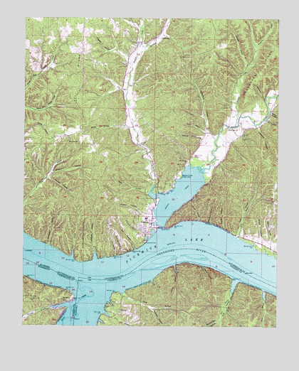
Waterloo, AL USGS Topographic Map
Click on map above to begin viewing in our Map Viewer.

This topographic map contains these locations and features:
Feature Name Type Latitude Longitude GNIS ID View Map
Adams Mill (historical)LocaleN34.9343°W88.0606°145041View Map
Backbone HollowValleyN34.9665°W88.0067°113328View Map
Bald HollowValleyN34.9037°W88.0786°113398View Map
Barn HollowValleyN34.9537°W88.0361°113486View Map
Barnett Mill HollowValleyN34.8770°W88.0280°113505View Map
Bear CreekStreamN34.8918°W88.0975°159128View Map
Beavers Mill (historical)LocaleN34.9490°W88.0681°145060View Map
Bee Tree Island (historical)IslandN34.9034°W88.0398°132814View Map
Beech BranchStreamN34.9026°W88.1011°113809View Map
Big Bear Shoals (historical)BarN34.9006°W88.1145°145074View Map
Bledsoe BranchStreamN34.8998°W88.0509°114490View Map
Boone BranchStreamN34.8893°W88.0061°114735View Map
Bumpas Creek School (historical)SchoolN34.9734°W88.0761°145090View Map
Bumpass CreekStreamN34.9318°W88.0618°115200View Map
Bumpass Creek ChurchChurchN34.9370°W88.0611°163818View Map
Bumpass Creek Freewill Baptist ChurchChurchN34.9729°W88.0761°145091View Map
Burkett HollowValleyN34.9170°W88.0336°115231View Map
Chickasaw (historical)Populated PlaceN34.8865°W88.0770°166017View Map
Chickasaw Crossing (historical)CrossingN34.8945°W88.0959°132835View Map
Chickasaw Post Office (historical)Post OfficeN34.8865°W88.0770°169248View Map
Colbert ShoalsBarN34.9015°W88.0625°132849View Map
Colbert Shoals Canal (historical)CanalN34.8948°W88.0200°132869View Map
Crows Camp (historical)Populated PlaceN34.9009°W88.0361°132857View Map
Cryder HollowValleyN34.9495°W88.0231°145132View Map
Dark HollowValleyN34.8892°W88.0761°117079View Map
Dike HollowValleyN34.9109°W88.0203°117281View Map
Dry CreekStreamN34.9809°W88.0725°145140View Map
EastportPopulated PlaceN34.8856°W88.1006°669629View Map
Eastport BranchStreamN34.8834°W88.1028°669630View Map
Eastport DockLocaleN34.8854°W88.1003°683126View Map
Eastport Landing (historical)LocaleN34.8948°W88.1036°689902View Map
Fannie HollowValleyN34.9345°W88.1131°118188View Map
Faulkner HollowValleyN34.9512°W88.0384°118219View Map
Fords Mill Missionary Baptist ChurchChurchN34.9556°W88.0250°118483View Map
Graveyard HollowValleyN34.9076°W88.1123°119284View Map
Hayes HollowValleyN34.8997°W88.0363°119893View Map
Hog HollowValleyN34.8939°W88.0200°120193View Map
Hogpen HollowValleyN34.9818°W88.0756°120211View Map
Horse BranchStreamN34.8806°W88.0856°120402View Map
Keaton HollowValleyN34.9195°W88.0620°151939View Map
Kennedy BranchStreamN34.9809°W88.0159°121148View Map
Lift Lock (historical)DamN34.8979°W88.0673°146248View Map
Lot HollowValleyN34.9593°W88.0052°122037View Map
Manbone CreekStreamN34.9562°W88.0220°122243View Map
Manbone RidgeRidgeN34.9851°W88.0025°122244View Map
Mathews (historical)Populated PlaceN34.9437°W88.0639°142098View Map
Mills HollowValleyN34.9284°W88.0648°122848View Map
Mount Hebron CemeteryCemeteryN34.9845°W88.0445°123203View Map
Mount Hebron Freewill Baptist Church (historical)ChurchN34.9840°W88.0442°142109View Map
Mount Olive (historical)Populated PlaceN34.9418°W88.0848°142111View Map
Mount Olive Freewill Baptist ChurchChurchN34.9504°W88.1036°152475View Map
Mount Olive School (historical)SchoolN34.9506°W88.1025°157361View Map
Palestine HollowValleyN34.9559°W88.0106°152834View Map
Palestine Methodist Church (historical)ChurchN34.9562°W88.0089°155448View Map
Pea RidgeRidgeN34.9779°W88.0995°124526View Map
Pickwick LakeReservoirN34.9023°W88.0387°1326389View Map
Potts BranchStreamN34.9109°W88.0203°125210View Map
Richardson BranchStreamN34.9106°W88.0639°125605View Map
Richardson CemeteryCemeteryN34.9092°W88.0656°125609View Map
RivertonPopulated PlaceN34.8806°W88.0767°153160View Map
Riverton Ferry (historical)CrossingN34.8954°W88.0736°133010View Map
Ross BranchStreamN34.8770°W88.0281°125955View Map
Salt HollowValleyN34.9062°W88.0700°126268View Map
Scott CemeteryCemeteryN34.9812°W88.0764°126484View Map
Second CreekStreamN34.9148°W88.0575°126520View Map
Second Creek Cabin AreaLocaleN34.9356°W88.0481°153362View Map
Second Creek Recreation AreaParkN34.9318°W88.0378°148827View Map
Sharp HollowValleyN34.9106°W88.0092°126638View Map
Sharp HollowValleyN34.9559°W88.0736°126639View Map
Shellbank LandingLocaleN34.9051°W88.1214°150839View Map
Shepherd HollowValleyN34.9368°W88.1114°153408View Map
Shepherd HollowValleyN34.9534°W88.0348°153409View Map
Sourwood SpringSpringN34.9848°W88.0739°142201View Map
South Riverton School (historical)SchoolN34.8793°W88.0767°155436View Map
Tanyard HollowValleyN34.9879°W88.0675°127691View Map
Threets ParkParkN34.9309°W88.0625°148826View Map
Till HollowValleyN34.9031°W88.0806°153695View Map
Town of WaterlooCivilN34.9172°W88.0654°2406837View Map
Tucker Bend (historical)BendN34.8890°W88.0917°150829View Map
Tucker HollowValleyN34.9151°W88.0273°128115View Map
Turpin HollowValleyN34.9818°W88.0153°142232View Map
Twomile HollowValleyN34.8820°W88.0612°128234View Map
Union Hollow School (historical)SchoolN34.9281°W88.1223°142242View Map
WaterlooPopulated PlaceN34.9181°W88.0642°128626View Map
Waterloo City ParkParkN34.9181°W88.0600°148824View Map
Waterloo DivisionCivilN34.9449°W88.0154°165838View Map
Waterloo High SchoolSchoolN34.9187°W88.0645°142248View Map
Waterloo Island (historical)IslandN34.9018°W88.0564°133066View Map
Waterloo LandingLocaleN34.8981°W88.0736°150842View Map
Waterloo Police DepartmentBuildingN34.9123°W88.0637°2751988View Map
Waterloo Post OfficePost OfficeN34.9146°W88.0628°2770177View Map
Waterloo Volunteer Fire and Rescue Department Station 1BuildingN34.9256°W88.0601°2683024View Map
Watkins CemeteryCemeteryN34.9079°W88.1131°141151View Map
Wesson HollowValleyN34.9106°W88.0089°128752View Map
Whitehead HollowValleyN34.9170°W88.0334°128898View Map
Whitsett HollowValleyN34.9023°W88.0898°128928View Map
Wolfpen HollowValleyN34.9616°W88.0034°154022View Map

Note: Coordinates in the location and feature list above are referenced to NAD83 datum.


Copyright (C) 2008-2024 Ryan Niemi / Sunset Dynamics ... All Rights Reserved