TopoQuest Logo
Do you find TopoQuest useful?
Help keep TopoQuest running and adding new maps/features by donating!
Bitcoin:  19c7KJd3qBynnjoSw5npx9KScwjBe4ifkT
Litecoin:  LXs6TkuXGGXo1vDsWCkWVdjQX94eUKd6ui
Home View Maps Find Maps Find Places Resources & Links


Marshall West, Texas Topographic Map

USGS Map Title: Marshall West, TX
USGS Map MRC: 32094E4
DRG (GeoTIFF) Download: o32094e4.tif


Neighboring USGS Topographic Map Quads:


  Harleton, TX  
32094F5
 

  Marshall NW, TX  
32094F4
 

  Woodlawn, TX  
32094F3
 

  Hallsville, TX  
32094E5
 

  Marshall West, TX  
32094E4
 

  Marshall East, TX  
32094E3
 

  Easton, TX  
32094D5
 

  Darco, TX  
32094D4
 

  Colliers Creek, TX  
32094D3


Map MRC Location:

N33°
W95°
N33°
W94°
H8 H7 H6 H5 H4 H3 H2 H1
G8 G7 G6 G5 G4 G3 G2 G1
F8 F7 F6 F5 F4 F3 F2 F1
E8 E7 E6 E5 E4 E3 E2 E1
D8 D7 D6 D5 D4 D3 D2 D1
C8 C7 C6 C5 C4 C3 C2 C1
B8 B7 B6 B5 B4 B3 B2 B1
A8 A7 A6 A5 A4 A3 A2 A1
N32°
W95°
N32°
W94°

Marshall West, TX USGS 1:24K Topographic Map Preview:
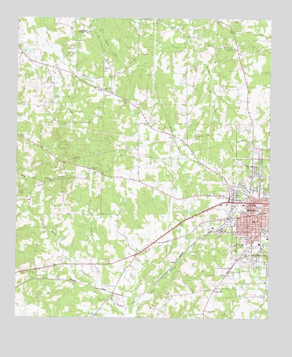
Marshall West, TX USGS Topographic Map
Click on map above to begin viewing in our Map Viewer.

This topographic map contains these locations and features:
Feature Name Type Latitude Longitude GNIS ID View Map
Austin SchoolSchoolN32.5440°W94.3799°1329859View Map
Carver SchoolSchoolN32.5313°W94.3883°1332253View Map
Cold Water CreekStreamN32.5113°W94.4546°1373157View Map
Dial-Williamson HouseBuildingN32.5513°W94.4221°2031342View Map
Dogan SchoolSchoolN32.5338°W94.3846°1334452View Map
Ebenezer ChurchChurchN32.5754°W94.4221°1335064View Map
Edwards Chapel ChurchChurchN32.5607°W94.3805°2020110View Map
G W Carver Elementary SchoolSchoolN32.5315°W94.3877°2006685View Map
Grange Hall SchoolSchoolN32.5032°W94.4041°1336815View Map
Green Star SchoolSchoolN32.6193°W94.4666°1336943View Map
Greenwood CemeteryCemeteryN32.5540°W94.3763°1336993View Map
Grover CemeteryCemeteryN32.5215°W94.4441°1337047View Map
Harrison County Constable's Office Precinct 2BuildingN32.5399°W94.3893°2751317View Map
Holy Temple Church of God in ChristChurchN32.5635°W94.3824°2020100View Map
Hope ChapelChurchN32.5093°W94.3769°1338047View Map
Immanuel Baptist ChurchChurchN32.5265°W94.3833°2020091View Map
Junior Moore Elementary SchoolSchoolN32.5679°W94.3835°2006695View Map
KEEP-FM (Marshall)TowerN32.5407°W94.4010°1385931View Map
Macedonia CemeteryCemeteryN32.6126°W94.3938°1340796View Map
Marshall DivisionCivilN32.5402°W94.3769°1938967View Map
Moore SchoolSchoolN32.5635°W94.3841°1341880View Map
Muckleroy CemeteryCemeteryN32.5185°W94.4902°1342186View Map
NesbittPopulated PlaceN32.5938°W94.4541°1378737View Map
Nesbitt CemeteryCemeteryN32.5901°W94.4480°1342422View Map
Nesbitt ChurchChurchN32.5951°W94.4583°1342423View Map
Nesbitt Volunteer Fire DepartmentBuildingN32.6025°W94.4769°2655147View Map
New Bethel ChurchChurchN32.5404°W94.3830°1342435View Map
New Hope ChurchChurchN32.5015°W94.4608°1342470View Map
New Zion CemeteryCemeteryN32.6135°W94.4921°1342550View Map
New Zion ChurchChurchN32.6096°W94.4983°1342554View Map
Oak Haven HomeBuildingN32.5951°W94.4566°1342984View Map
Peoples Missionary Baptist ChurchChurchN32.5360°W94.3910°2020093View Map
Pettit Oil FieldOilfieldN32.5951°W94.4946°1343916View Map
Potters Creek ChurchChurchN32.5615°W94.4613°1344440View Map
Price T Young Middle SchoolSchoolN32.5315°W94.3794°2006597View Map
QuineyPopulated PlaceN32.5235°W94.4205°1378922View Map
Rock Springs ChurchChurchN32.5574°W94.4824°1345404View Map
Snider LakeReservoirN32.5768°W94.4085°1864350View Map
Snider Lake DamDamN32.5768°W94.4085°1864349View Map
Spring Street ParkParkN32.5415°W94.3780°2029322View Map
Springhill ChurchChurchN32.6190°W94.4680°1347760View Map
Sunnyhill ChurchChurchN32.6038°W94.4574°1348076View Map
T and P HospitalHospitalN32.5476°W94.3827°1348182View Map
Tage CemeteryCemeteryN32.5876°W94.4580°1348203View Map
Town of NesbittCivilN32.5984°W94.4592°2413039View Map
Ward Chapel African Methodist Episcopal ChurchChurchN32.5404°W94.3858°2020081View Map
Washington Early Childhood CenterSchoolN32.5540°W94.3799°2006601View Map
Wiley CollegeSchoolN32.5371°W94.3766°1350091View Map
Wiley College CemeteryCemeteryN32.5218°W94.3785°1350092View Map
Word of Life Bible Fellowship ChurchChurchN32.5401°W94.3910°2020112View Map

Note: Coordinates in the location and feature list above are referenced to NAD83 datum.


Copyright (C) 2008-2025 Ryan Niemi / Sunset Dynamics ... All Rights Reserved