TopoQuest Logo
Do you find TopoQuest useful?
Help keep TopoQuest running and adding new maps/features by donating!
Bitcoin:  19c7KJd3qBynnjoSw5npx9KScwjBe4ifkT
Litecoin:  LXs6TkuXGGXo1vDsWCkWVdjQX94eUKd6ui
Home View Maps Find Maps Find Places Resources & Links


Marshallville, Georgia Topographic Map

USGS Map Title: Marshallville, GA
USGS Map MRC: 32083D8
DRG (GeoTIFF) Download: o32083d8.tif


Neighboring USGS Topographic Map Quads:


  Reynolds, GA  
32084E1
 

  Fort Valley West, GA  
32083E8
 

  Fort Valley East, GA  
32083E7
 

  Garden Valley, GA  
32084D1
 

  Marshallville, GA  
32083D8
 

  Perry West, GA  
32083D7
 

  Montezuma, GA  
32084C1
 

  Marshallville SW, GA  
32083C8
 

  Henderson, GA  
32083C7


Map MRC Location:

N33°
W84°
N33°
W83°
H8 H7 H6 H5 H4 H3 H2 H1
G8 G7 G6 G5 G4 G3 G2 G1
F8 F7 F6 F5 F4 F3 F2 F1
E8 E7 E6 E5 E4 E3 E2 E1
D8 D7 D6 D5 D4 D3 D2 D1
C8 C7 C6 C5 C4 C3 C2 C1
B8 B7 B6 B5 B4 B3 B2 B1
A8 A7 A6 A5 A4 A3 A2 A1
N32°
W84°
N32°
W83°

Marshallville, GA USGS 1:24K Topographic Map Preview:
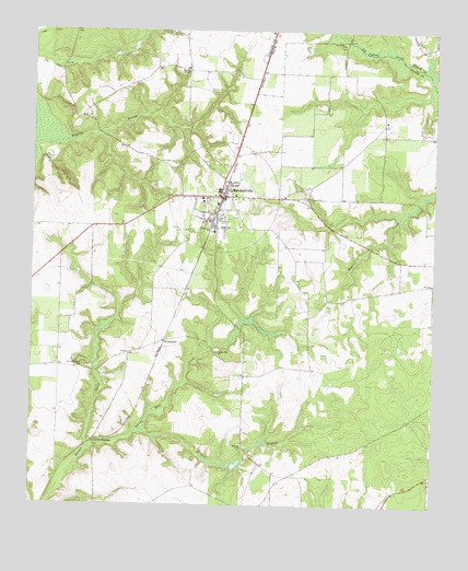
Marshallville, GA USGS Topographic Map
Click on map above to begin viewing in our Map Viewer.

This topographic map contains these locations and features:
Feature Name Type Latitude Longitude GNIS ID View Map
Bethel Baptist ChurchChurchN32.4604°W83.9388°346939View Map
City of MarshallvilleCivilN32.4564°W83.9407°2405030View Map
East Main Street Residential Historic DistrictParkN32.4563°W83.9388°346945View Map
First Baptist ChurchChurchN32.4568°W83.9371°346948View Map
Friendship ChurchChurchN32.4968°W83.9035°314410View Map
Glorious Hope Primitive Baptist ChurchChurchN32.4527°W83.9455°346953View Map
Harden ChapelChurchN32.4896°W83.9507°315116View Map
J W Frederick Memorial LibraryBuildingN32.4571°W83.9421°346956View Map
Lowes CrossingPopulated PlaceN32.3918°W83.9802°326379View Map
MarshallvillePopulated PlaceN32.4563°W83.9402°356378View Map
Marshallville CemeteryCemeteryN32.4551°W83.9457°346963View Map
Marshallville City HallBuildingN32.4565°W83.9421°346964View Map
Marshallville DivisionCivilN32.4427°W83.9449°1936394View Map
Marshallville Fire DepartmentBuildingN32.4620°W83.9401°2603772View Map
Marshallville Methodist ChurchChurchN32.4563°W83.9457°346965View Map
Marshallville Police DepartmentBuildingN32.4565°W83.9414°2734016View Map
Marshallville Post OfficePost OfficeN32.4568°W83.9432°346966View Map
Richardson SchoolSchoolN32.4471°W83.9427°321573View Map
Saint James Christian Methodist Episcopal ChurchChurchN32.4521°W83.9432°346980View Map
Saint Johns African Methodist Episcopal ChurchChurchN32.4510°W83.9438°346981View Map
Saint Paul BranchStreamN32.3946°W83.9646°322225View Map
Saint Pauls ChurchChurchN32.3904°W83.9335°322263View Map
Spring Hill ChurchChurchN32.4152°W83.9419°323425View Map
Spring Hill CreekStreamN32.3890°W83.9827°323439View Map
Willow LakePopulated PlaceN32.4757°W83.8910°1730637View Map
WinchesterPopulated PlaceN32.4182°W83.9577°326594View Map

Note: Coordinates in the location and feature list above are referenced to NAD83 datum.


Copyright (C) 2008-2025 Ryan Niemi / Sunset Dynamics ... All Rights Reserved