TopoQuest Logo
Do you find TopoQuest useful?
Help keep TopoQuest running and adding new maps/features by donating!
Bitcoin:  19c7KJd3qBynnjoSw5npx9KScwjBe4ifkT
Litecoin:  LXs6TkuXGGXo1vDsWCkWVdjQX94eUKd6ui
Home View Maps Find Maps Find Places Resources & Links


Reynolds, Georgia Topographic Map

USGS Map Title: Reynolds, GA
USGS Map MRC: 32084E1
DRG (GeoTIFF) Download: o32084e1.tif


Neighboring USGS Topographic Map Quads:


  Fickling Mill, GA  
32084F2
 

  Roberta, GA  
32084F1
 

  Knoxville, GA  
32083F8
 

  Butler East, GA  
32084E2
 

  Reynolds, GA  
32084E1
 

  Fort Valley West, GA  
32083E8
 

  Ideal North, GA  
32084D2
 

  Garden Valley, GA  
32084D1
 

  Marshallville, GA  
32083D8


Map MRC Location:

N33°
W85°
N33°
W84°
H8 H7 H6 H5 H4 H3 H2 H1
G8 G7 G6 G5 G4 G3 G2 G1
F8 F7 F6 F5 F4 F3 F2 F1
E8 E7 E6 E5 E4 E3 E2 E1
D8 D7 D6 D5 D4 D3 D2 D1
C8 C7 C6 C5 C4 C3 C2 C1
B8 B7 B6 B5 B4 B3 B2 B1
A8 A7 A6 A5 A4 A3 A2 A1
N32°
W85°
N32°
W84°

Reynolds, GA USGS 1:24K Topographic Map Preview:
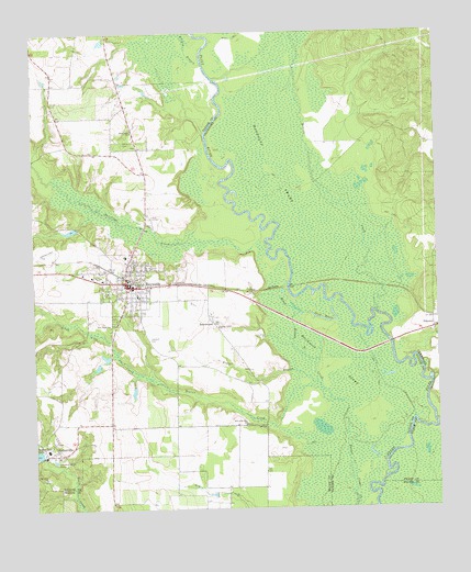
Reynolds, GA USGS Topographic Map
Click on map above to begin viewing in our Map Viewer.

This topographic map contains these locations and features:
Feature Name Type Latitude Longitude GNIS ID View Map
Beaver CreekStreamN32.5518°W84.0188°310981View Map
BeechwoodPopulated PlaceN32.5490°W84.0694°326176View Map
Beechwood SwampSwampN32.5407°W84.0352°311035View Map
Black Bottom CreekStreamN32.5276°W84.0299°311463View Map
Brunson LakeReservoirN32.5310°W84.0942°340608View Map
Brunson Lake DamDamN32.5318°W84.0949°340607View Map
City of ReynoldsCivilN32.5608°W84.0945°2404609View Map
Dead RiverLakeN32.5495°W84.0348°313383View Map
Fraser BranchStreamN32.5279°W84.0321°314357View Map
Glover CemeteryCemeteryN32.6071°W84.1188°314649View Map
Gordon Grove ChurchChurchN32.5476°W84.0677°314714View Map
Griffin BranchStreamN32.6168°W84.0710°314901View Map
Little Vine CreekStreamN32.5340°W84.0885°317234View Map
Magnolia SwampSwampN32.5907°W84.0502°317626View Map
Mount Olive CemeteryCemeteryN32.5085°W84.1213°344146View Map
Mount Olive ChurchChurchN32.5088°W84.1221°318751View Map
NakomisPopulated PlaceN32.5468°W84.0010°326415View Map
New Free Run ChurchChurchN32.5218°W84.0594°319318View Map
New Hope CemeteryCemeteryN32.5479°W84.1013°344149View Map
New Hope ChurchChurchN32.5482°W84.1010°319396View Map
Newsom CemeteryCemeteryN32.5449°W84.0891°319580View Map
Patsiliga CreekStreamN32.5729°W84.0535°320270View Map
PottervillePopulated PlaceN32.5146°W84.1174°332747View Map
ReynoldsPopulated PlaceN32.5599°W84.0963°321535View Map
Reynolds DivisionCivilN32.5584°W84.1047°1936491View Map
Reynolds Police DepartmentBuildingN32.5600°W84.0955°2733937View Map
Ricks LakeReservoirN32.5468°W84.1093°340450View Map
Ricks Lake DamDamN32.5468°W84.1082°340449View Map
Taylor County Fire and Rescue Department Potterville StationBuildingN32.5142°W84.1188°2604732View Map
Taylor County Fire and Rescue Department Reynolds StationBuildingN32.5562°W84.0929°2604584View Map
Taylor Mill Missionary ChurchChurchN32.5143°W84.1191°344161View Map
Wainwright LakeReservoirN32.5989°W84.1196°337397View Map
Wainwright Lake DamDamN32.5968°W84.1216°337396View Map
Whatley LakeReservoirN32.5734°W84.1132°340448View Map
Whatley Lake DamDamN32.5735°W84.1116°340447View Map
White Hill CemeteryCemeteryN32.5965°W84.0966°325157View Map
White Hill ChurchChurchN32.5990°W84.0938°325158View Map

Note: Coordinates in the location and feature list above are referenced to NAD83 datum.


Copyright (C) 2008-2024 Ryan Niemi / Sunset Dynamics ... All Rights Reserved