TopoQuest Logo
Do you find TopoQuest useful?
Help keep TopoQuest running and adding new maps/features by donating!
Bitcoin:  19c7KJd3qBynnjoSw5npx9KScwjBe4ifkT
Litecoin:  LXs6TkuXGGXo1vDsWCkWVdjQX94eUKd6ui
Home View Maps Find Maps Find Places Resources & Links


Fort Valley East, Georgia Topographic Map

USGS Map Title: Fort Valley East, GA
USGS Map MRC: 32083E7
DRG (GeoTIFF) Download: o32083e7.tif


Neighboring USGS Topographic Map Quads:


  Knoxville, GA  
32083F8
 

  Byron, GA  
32083F7
 

  Warner Robins NW, GA  
32083F6
 

  Fort Valley West, GA  
32083E8
 

  Fort Valley East, GA  
32083E7
 

  Warner Robins SW, GA  
32083E6
 

  Marshallville, GA  
32083D8
 

  Perry West, GA  
32083D7
 

  Perry East, GA  
32083D6


Map MRC Location:

N33°
W84°
N33°
W83°
H8 H7 H6 H5 H4 H3 H2 H1
G8 G7 G6 G5 G4 G3 G2 G1
F8 F7 F6 F5 F4 F3 F2 F1
E8 E7 E6 E5 E4 E3 E2 E1
D8 D7 D6 D5 D4 D3 D2 D1
C8 C7 C6 C5 C4 C3 C2 C1
B8 B7 B6 B5 B4 B3 B2 B1
A8 A7 A6 A5 A4 A3 A2 A1
N32°
W84°
N32°
W83°

Fort Valley East, GA USGS 1:24K Topographic Map Preview:
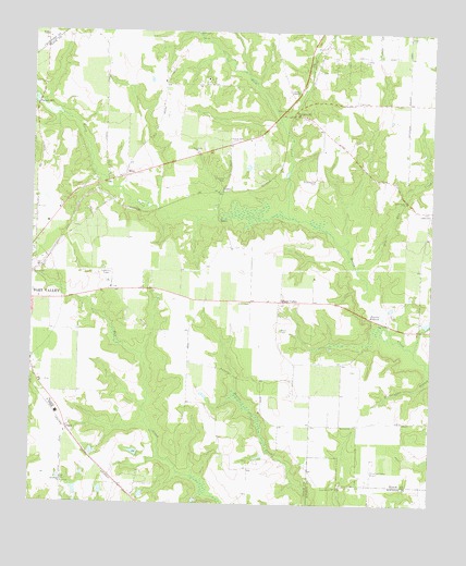
Fort Valley East, GA USGS Topographic Map
Click on map above to begin viewing in our Map Viewer.

This topographic map contains these locations and features:
Feature Name Type Latitude Longitude GNIS ID View Map
AlbaughPopulated PlaceN32.5457°W83.8257°1730638View Map
Allen ChapelChurchN32.5535°W83.8060°310452View Map
Bethel ChurchChurchN32.6046°W83.7952°311181View Map
Big Dog - Cameron FieldAirportN32.5479°W83.8268°2442677View Map
BissPopulated PlaceN32.5865°W83.8457°331171View Map
Bryn MawrPopulated PlaceN32.5679°W83.8127°1730639View Map
Byron DivisionCivilN32.6212°W83.7592°1936148View Map
Church of ChristChurchN32.5779°W83.8666°343125View Map
Cleveland DamDamN32.5868°W83.7949°336298View Map
Cleveland LakeReservoirN32.5898°W83.7946°336299View Map
Cliett CemeteryCemeteryN32.6071°W83.7732°312745View Map
Davis Hill ChurchChurchN32.5049°W83.7794°355449View Map
Davis Hill School (historical)SchoolN32.5046°W83.7799°1671650View Map
Diamond CemeteryCemeteryN32.5863°W83.8146°313463View Map
Dry Run CreekStreamN32.5621°W83.7732°313687View Map
EdgewoodPopulated PlaceN32.5565°W83.8402°1730640View Map
FaganPopulated PlaceN32.5199°W83.8635°326273View Map
Fairview ChurchChurchN32.6110°W83.8719°314048View Map
Fort Valley DivisionCivilN32.5417°W83.8618°1936277View Map
Full Gospel Lighthouse ChurchChurchN32.5749°W83.8685°343142View Map
Housers MillpondReservoirN32.5508°W83.7662°315738View Map
Lisenby CemeteryCemeteryN32.6182°W83.7713°316922View Map
Little Bethel ChurchChurchN32.5810°W83.7577°316951View Map
Lizzie ChapelChurchN32.6096°W83.7919°317264View Map
Macedonia ChurchChurchN32.5057°W83.8644°317545View Map
Miami CemeteryCemeteryN32.5463°W83.7966°318061View Map
Miami ValleyPopulated PlaceN32.5538°W83.7966°332378View Map
Miami Valley Farm AirportAirportN32.5499°W83.8011°351774View Map
Mount Pleasant ChurchChurchN32.6249°W83.8232°318841View Map
Mule CreekStreamN32.5763°W83.7941°319141View Map
New Faith ChurchChurchN32.5932°W83.8232°319313View Map
Oak GrovePopulated PlaceN32.5293°W83.7924°1730641View Map
OhioPopulated PlaceN32.5829°W83.8157°1730642View Map
Peach CountyCivilN32.5688°W83.8269°343153View Map
Peach County Fire Department Station 1BuildingN32.6109°W83.7921°2604609View Map
Peach County Fire Department Station 2BuildingN32.5331°W83.8718°2604627View Map
Peach County Fire Department Station 5BuildingN32.5535°W83.7922°2604626View Map
Perry-Houston County AirportAirportN32.5070°W83.7695°326828View Map
Pineola FarmsLocaleN32.5811°W83.8747°2546820View Map
PowersvillePopulated PlaceN32.6040°W83.7927°332753View Map
Powersville ChurchChurchN32.6029°W83.7902°343163View Map
Saint John ChurchChurchN32.5565°W83.8399°343166View Map
Scattergood CemeteryCemeteryN32.5863°W83.7860°322622View Map
Smith FieldAirportN32.6023°W83.7530°2442687View Map
South Peach Industrial ParkLocaleN32.5376°W83.8702°343169View Map
Taylors MillPopulated PlaceN32.6060°W83.8738°333199View Map
Wesley ChapelChurchN32.6235°W83.8702°325011View Map
Wesley Chapel CemeteryCemeteryN32.6238°W83.8707°342970View Map
Whipple DamDamN32.5151°W83.8549°336304View Map
Whipple LakeReservoirN32.5138°W83.8556°336305View Map
WKXK-FM (Fort Valley)TowerN32.5701°W83.7571°352695View Map
WQBZ-FM (Fort Valley)TowerN32.5790°W83.8730°352693View Map

Note: Coordinates in the location and feature list above are referenced to NAD83 datum.


Copyright (C) 2008-2024 Ryan Niemi / Sunset Dynamics ... All Rights Reserved