TopoQuest Logo
Do you find TopoQuest useful?
Help keep TopoQuest running and adding new maps/features by donating!
Bitcoin:  19c7KJd3qBynnjoSw5npx9KScwjBe4ifkT
Litecoin:  LXs6TkuXGGXo1vDsWCkWVdjQX94eUKd6ui
Home View Maps Find Maps Find Places Resources & Links


Perry West, Georgia Topographic Map

USGS Map Title: Perry West, GA
USGS Map MRC: 32083D7
DRG (GeoTIFF) Download: o32083d7.tif


Neighboring USGS Topographic Map Quads:


  Fort Valley West, GA  
32083E8
 

  Fort Valley East, GA  
32083E7
 

  Warner Robins SW, GA  
32083E6
 

  Marshallville, GA  
32083D8
 

  Perry West, GA  
32083D7
 

  Perry East, GA  
32083D6
 

  Marshallville SW, GA  
32083C8
 

  Henderson, GA  
32083C7
 

  Unadilla, GA  
32083C6


Map MRC Location:

N33°
W84°
N33°
W83°
H8 H7 H6 H5 H4 H3 H2 H1
G8 G7 G6 G5 G4 G3 G2 G1
F8 F7 F6 F5 F4 F3 F2 F1
E8 E7 E6 E5 E4 E3 E2 E1
D8 D7 D6 D5 D4 D3 D2 D1
C8 C7 C6 C5 C4 C3 C2 C1
B8 B7 B6 B5 B4 B3 B2 B1
A8 A7 A6 A5 A4 A3 A2 A1
N32°
W84°
N32°
W83°

Perry West, GA USGS 1:24K Topographic Map Preview:
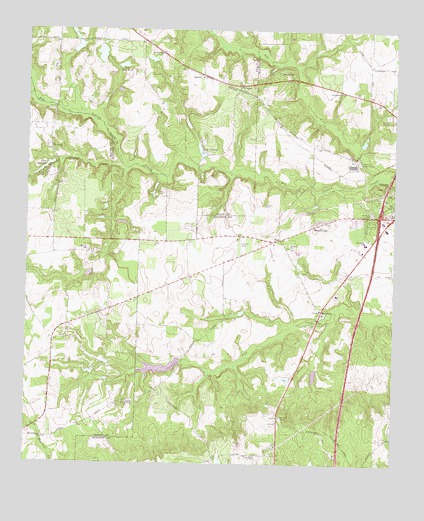
Perry West, GA USGS Topographic Map
Click on map above to begin viewing in our Map Viewer.

This topographic map contains these locations and features:
Feature Name Type Latitude Longitude GNIS ID View Map
Baptist CreekStreamN32.4607°W83.8419°310783View Map
Bay CreekStreamN32.4579°W83.7544°310889View Map
Beaver CreekStreamN32.4907°W83.7852°310979View Map
Belvin ChurchChurchN32.4110°W83.8605°354543View Map
Bonnie Brae SubdivisionPopulated PlaceN32.4838°W83.7924°1671627View Map
Browns ChapelChurchN32.3921°W83.8402°311893View Map
Camp HopeLocaleN32.4574°W83.8691°354969View Map
ClopinePopulated PlaceN32.4840°W83.8019°331418View Map
Davis ChapelChurchN32.3774°W83.7982°313347View Map
Davis Chapel School (historical)SchoolN32.3774°W83.7985°1671648View Map
Davis-Felton PlantationLocaleN32.3754°W83.8096°1671649View Map
Dumas LakeReservoirN32.4185°W83.8216°340157View Map
Dumas Lake DamDamN32.4185°W83.8216°340156View Map
Exit 42CrossingN32.4468°W83.7549°1671664View Map
Forbes DamDamN32.4352°W83.8482°340316View Map
Forbes LakeReservoirN32.4302°W83.8534°340317View Map
Free LakeReservoirN32.4029°W83.8290°340969View Map
Free Lake DamDamN32.4035°W83.8232°340968View Map
Hoses CemeteryCemeteryN32.4502°W83.7938°315732View Map
Houston County Fire Department Station 8BuildingN32.4393°W83.7879°2603549View Map
John Schofeld DamDamN32.4901°W83.8316°336316View Map
John Schofeld LakeReservoirN32.4918°W83.8331°336317View Map
Kings Crest SubdivisionPopulated PlaceN32.4835°W83.7857°1671707View Map
Lake Blue BirdReservoirN32.4898°W83.8427°311541View Map
Lake Blue Bird DamDamN32.4899°W83.8419°336312View Map
Lake ClopineReservoirN32.4653°W83.8160°336315View Map
Lake Clopine DamDamN32.4657°W83.8157°336314View Map
Lake LasseterReservoirN32.4602°W83.8692°316656View Map
Lake Lasseter DamDamN32.4602°W83.8685°337408View Map
Louis Newberry DamDamN32.4918°W83.8482°336308View Map
Louis Newberry LakeReservoirN32.4928°W83.8500°336309View Map
Lucy Giles DamDamN32.4935°W83.8599°336310View Map
Lucy Giles LakeReservoirN32.4950°W83.8580°336311View Map
Marthan ChurchChurchN32.4474°W83.7580°317730View Map
MeadowdalePopulated PlaceN32.4446°W83.7757°332363View Map
Midway ChurchChurchN32.4879°W83.8163°343150View Map
Moss OakPopulated PlaceN32.4196°W83.7743°318532View Map
Mount Zion ChurchChurchN32.4377°W83.7855°318977View Map
MyrtlePopulated PlaceN32.4874°W83.8155°332459View Map
NealPopulated PlaceN32.4402°W83.7882°332469View Map
Oak KnollsPopulated PlaceN32.4888°W83.7880°332531View Map
Perry Industrial ParkLocaleN32.4613°W83.7644°1671736View Map
Richland ChurchChurchN32.4932°W83.8294°321576View Map
Saint LouisPopulated PlaceN32.4654°W83.8669°332956View Map
Saint Louis ChurchChurchN32.4649°W83.8663°346983View Map
Westfield SchoolSchoolN32.4393°W83.7593°325088View Map

Note: Coordinates in the location and feature list above are referenced to NAD83 datum.


Copyright (C) 2008-2025 Ryan Niemi / Sunset Dynamics ... All Rights Reserved