TopoQuest Logo
Do you find TopoQuest useful?
Help keep TopoQuest running and adding new maps/features by donating!
Bitcoin:  19c7KJd3qBynnjoSw5npx9KScwjBe4ifkT
Litecoin:  LXs6TkuXGGXo1vDsWCkWVdjQX94eUKd6ui
Home View Maps Find Maps Find Places Resources & Links


Marshlands, Pennsylvania Topographic Map

USGS Map Title: Marshlands, PA
USGS Map MRC: 41077F5
DRG (GeoTIFF) Download: o41077f5.tif


Neighboring USGS Topographic Map Quads:


  West Pike, PA  
41077G6
 

  Sabinsville, PA  
41077G5
 

  Asaph, PA  
41077G4
 

  Galeton, PA  
41077F6
 

  Marshlands, PA  
41077F5
 

  Tiadaghton, PA  
41077F4
 

  Oleona, PA  
41077E6
 

  Lee Fire Tower, PA  
41077E5
 

  Cedar Run, PA  
41077E4


Map MRC Location:

N42°
W78°
N42°
W77°
H8 H7 H6 H5 H4 H3 H2 H1
G8 G7 G6 G5 G4 G3 G2 G1
F8 F7 F6 F5 F4 F3 F2 F1
E8 E7 E6 E5 E4 E3 E2 E1
D8 D7 D6 D5 D4 D3 D2 D1
C8 C7 C6 C5 C4 C3 C2 C1
B8 B7 B6 B5 B4 B3 B2 B1
A8 A7 A6 A5 A4 A3 A2 A1
N41°
W78°
N41°
W77°

Marshlands, PA USGS 1:24K Topographic Map Preview:
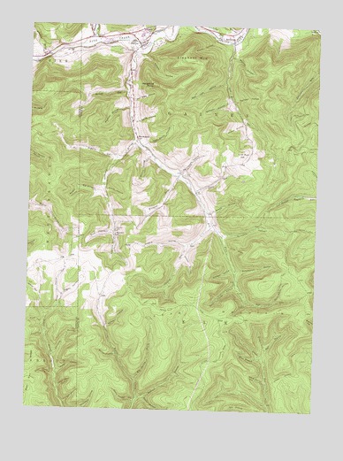
Marshlands, PA USGS Topographic Map
Click on map above to begin viewing in our Map Viewer.

This topographic map contains these locations and features:
Feature Name Type Latitude Longitude GNIS ID View Map
Babylon RunStreamN41.7065°W77.5858°1168550View Map
Bailey HollowValleyN41.6431°W77.5858°1168578View Map
Bake Oven TrailTrailN41.7045°W77.5019°1190975View Map
Benaur HollowValleyN41.7407°W77.5753°1169225View Map
Big HollowValleyN41.6970°W77.5936°1169520View Map
Big Spring BrookStreamN41.6348°W77.5772°1169592View Map
Big Spring Brook TrailTrailN41.6501°W77.5705°1205885View Map
Billings BranchStreamN41.6287°W77.5761°1169622View Map
Billings TrailTrailN41.6292°W77.5736°1205884View Map
Bloody RunStreamN41.7284°W77.5833°1169836View Map
Cedar MountainSummitN41.6551°W77.5764°1171391View Map
Chaffee RunStreamN41.6848°W77.5464°1171526View Map
Chestnut TrailTrailN41.6678°W77.5139°1171760View Map
D A Smith HollowValleyN41.7184°W77.5797°1172881View Map
Dead Bear HollowValleyN41.6322°W77.6102°1173020View Map
Dead Horse HollowValleyN41.6606°W77.5175°1173023View Map
Decker HollowValleyN41.7459°W77.5453°1173045View Map
Deer Lick HollowValleyN41.7321°W77.5402°1173096View Map
Dewey HollowValleyN41.6896°W77.5458°1173217View Map
Dewey Hollow TrailTrailN41.6962°W77.5189°1205888View Map
Dimmick HollowValleyN41.6427°W77.6125°1173280View Map
East Branch Cedar RunStreamN41.6420°W77.5214°1173734View Map
Elephant MountainSummitN41.7392°W77.5564°1174089View Map
Elk RunStreamN41.7412°W77.5786°1174124View Map
Elk Run Post Office (historical)Post OfficeN41.7134°W77.5780°1214382View Map
Fegley HollowValleyN41.6615°W77.6098°1174658View Map
First HollowValleyN41.6530°W77.6182°1174787View Map
First Switchback TrailTrailN41.7220°W77.5103°1174794View Map
Gaines JunctionPopulated PlaceN41.7473°W77.5736°1203648View Map
Gas Well HollowValleyN41.7251°W77.5796°1175476View Map
Gilbert RunStreamN41.6448°W77.5208°1175603View Map
Gormania BranchStreamN41.7128°W77.5789°1175843View Map
Grim HollowValleyN41.6832°W77.5878°1176233View Map
Gross HollowValleyN41.6549°W77.6165°1176265View Map
Half Mile TrailTrailN41.6303°W77.5355°1176382View Map
Hedgehog PointSummitN41.7309°W77.5714°1176759View Map
Hubers HollowValleyN41.6791°W77.5544°1177536View Map
Hurlbert HollowValleyN41.7253°W77.5360°1177640View Map
John Smith HollowValleyN41.7108°W77.5753°1178100View Map
Johnny McHood TrailTrailN41.6426°W77.5086°1178101View Map
Johnson BrookStreamN41.7398°W77.6186°1178107View Map
Kohler HollowValleyN41.6751°W77.5564°1178636View Map
Lewis RunStreamN41.6959°W77.5519°1179243View Map
Lick RunStreamN41.7440°W77.5375°1179303View Map
Lick Run HillSummitN41.7081°W77.5333°1179310View Map
Long RunStreamN41.7456°W77.5433°1179898View Map
Long Warrant TrailTrailN41.6609°W77.5650°1179912View Map
Madison HollowStreamN41.7231°W77.5819°1180179View Map
Madison HollowValleyN41.7263°W77.5382°1180180View Map
ManhattanPopulated PlaceN41.7470°W77.5380°1204092View Map
Maple HollowValleyN41.6292°W77.5730°1180350View Map
MarshlandsPopulated PlaceN41.7134°W77.5786°1204107View Map
Mattison - Lick Run CemeteryCemeteryN41.7255°W77.5391°2774834View Map
Maynard CemeteryCemeteryN41.6836°W77.5867°1180578View Map
Maynard HollowValleyN41.6831°W77.5873°1180580View Map
Maynard SchoolSchoolN41.6815°W77.5867°1180581View Map
McCracker HollowValleyN41.7027°W77.5588°1180671View Map
Mill RunStreamN41.6609°W77.5294°1181183View Map
Mitchell HollowValleyN41.6713°W77.5361°1181374View Map
Nolton - Knowlton - Elk Run CemeteryCemeteryN41.7013°W77.5574°1182501View Map
O'Connor TrailTrailN41.6845°W77.5033°1182726View Map
Olive DraftValleyN41.6779°W77.5377°1182973View Map
Parker HollowValleyN41.6519°W77.5897°1183318View Map
Phoenix CemeteryCemeteryN41.7464°W77.5961°1183686View Map
Phoenix RunStreamN41.7448°W77.5953°1183690View Map
Reese HollowValleyN41.6374°W77.6108°1184844View Map
Schoonover HollowValleyN41.6704°W77.5335°1187122View Map
Sease HollowValleyN41.6964°W77.5913°1187203View Map
Shaar HollowValleyN41.6622°W77.6194°1187286View Map
Shaver HollowValleyN41.7184°W77.5321°1187390View Map
Shin HollowValleyN41.7484°W77.5340°1187527View Map
Sixth HollowValleyN41.6362°W77.6123°1187744View Map
Straitz HollowValleyN41.7076°W77.5729°1188847View Map
Swope HollowValleyN41.6968°W77.6021°1189198View Map
Third HollowValleyN41.6487°W77.6170°1189459View Map
Thompson HollowValleyN41.6821°W77.5398°1189502View Map
Tin Can HollowValleyN41.6272°W77.6075°1189578View Map
Township of GainesCivilN41.7488°W77.5478°1217111View Map
WaltrousPopulated PlaceN41.7437°W77.5761°1190568View Map
Water Tank TrailTrailN41.6373°W77.5155°1205883View Map
Water Trough HollowValleyN41.6661°W77.5345°1190668View Map
Water Trough HollowValleyN41.6280°W77.5771°1193615View Map
Watrous CemeteryCemeteryN41.7435°W77.5778°2774861View Map
West Branch Cedar RunStreamN41.6420°W77.5228°1190893View Map
Wetmore RunStreamN41.7006°W77.5600°1191192View Map
White Horse HollowValleyN41.6351°W77.5208°1191284View Map
Whitney HollowValleyN41.7401°W77.5380°1191359View Map

Note: Coordinates in the location and feature list above are referenced to NAD83 datum.


Copyright (C) 2008-2024 Ryan Niemi / Sunset Dynamics ... All Rights Reserved