TopoQuest Logo
Do you find TopoQuest useful?
Help keep TopoQuest running and adding new maps/features by donating!
Bitcoin:  19c7KJd3qBynnjoSw5npx9KScwjBe4ifkT
Litecoin:  LXs6TkuXGGXo1vDsWCkWVdjQX94eUKd6ui
Home View Maps Find Maps Find Places Resources & Links


Galeton, Pennsylvania Topographic Map

USGS Map Title: Galeton, PA
USGS Map MRC: 41077F6
DRG (GeoTIFF) Download: o41077f6.tif


Neighboring USGS Topographic Map Quads:


  Brookland, PA  
41077G7
 

  West Pike, PA  
41077G6
 

  Sabinsville, PA  
41077G5
 

  Cherry Springs, PA  
41077F7
 

  Galeton, PA  
41077F6
 

  Marshlands, PA  
41077F5
 

  Short Run, PA  
41077E7
 

  Oleona, PA  
41077E6
 

  Lee Fire Tower, PA  
41077E5


Map MRC Location:

N42°
W78°
N42°
W77°
H8 H7 H6 H5 H4 H3 H2 H1
G8 G7 G6 G5 G4 G3 G2 G1
F8 F7 F6 F5 F4 F3 F2 F1
E8 E7 E6 E5 E4 E3 E2 E1
D8 D7 D6 D5 D4 D3 D2 D1
C8 C7 C6 C5 C4 C3 C2 C1
B8 B7 B6 B5 B4 B3 B2 B1
A8 A7 A6 A5 A4 A3 A2 A1
N41°
W78°
N41°
W77°

Galeton, PA USGS 1:24K Topographic Map Preview:
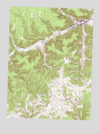
Galeton, PA USGS Topographic Map
Click on map above to begin viewing in our Map Viewer.

This topographic map contains these locations and features:
Feature Name Type Latitude Longitude GNIS ID View Map
Acid Factory HollowValleyN41.7086°W77.6358°1168041View Map
Bach HollowValleyN41.6428°W77.6480°1168551View Map
Baders HollowValleyN41.6481°W77.6563°1168567View Map
Bean HillSummitN41.6287°W77.6605°1168846View Map
Beech Flats RunStreamN41.7192°W77.6836°1169102View Map
Bibiana MountainSummitN41.6367°W77.6386°1169465View Map
Birch Still HollowValleyN41.6800°W77.6430°1169649View Map
Blumenthal HollowValleyN41.6435°W77.7023°1169906View Map
Boedler BranchStreamN41.6478°W77.6611°1169931View Map
Bohunk HollowValleyN41.6756°W77.7314°1169946View Map
Borough of GaletonCivilN41.7338°W77.6454°1215538View Map
Brushy PointSummitN41.6640°W77.7061°1170477View Map
Bull Tote Road TrailTrailN41.6712°W77.7028°1170653View Map
BurrowsPopulated PlaceN41.6937°W77.7497°1203196View Map
Butternut HollowValleyN41.7087°W77.6522°1170817View Map
Button HollowValleyN41.6935°W77.6360°1170823View Map
Byam CemeteryCemeteryN41.6951°W77.6393°1170832View Map
Carter CampLocaleN41.6281°W77.7150°1171281View Map
Clark Farm TrailTrailN41.7467°W77.6372°1171909View Map
Club HillSummitN41.6423°W77.6705°1172037View Map
Cow Hill TrailTrailN41.6373°W77.7419°1172543View Map
Crippen HollowValleyN41.7248°W77.6625°1172696View Map
Crippen RunStreamN41.7115°W77.7019°1172697View Map
Dead Horse HollowValleyN41.6877°W77.7447°1173024View Map
Deer Lick HollowValleyN41.7281°W77.6409°1173095View Map
Egler HollowValleyN41.7379°W77.6590°1174042View Map
Falling Springs HollowValleyN41.7422°W77.6702°1174594View Map
Gale Hose AmbulanceBuildingN41.7332°W77.6505°2719640View Map
GaletonPopulated PlaceN41.7331°W77.6419°1175386View Map
Galeton Borough Police DepartmentBuildingN41.7345°W77.6489°2776982View Map
Galeton DamDamN41.7334°W77.6430°1195761View Map
Galeton LakeReservoirN41.7334°W77.6430°1195760View Map
Galeton Post OfficePost OfficeN41.7344°W77.6426°2772710View Map
GermaniaPopulated PlaceN41.6476°W77.6603°1203662View Map
Germania Bridge TrailTrailN41.6926°W77.7275°1175555View Map
Germania Fire CompanyBuildingN41.6492°W77.6621°2645486View Map
Germania HillSummitN41.6737°W77.6522°1175556View Map
Germania Post Office (historical)Post OfficeN41.6462°W77.6605°1214186View Map
Germania StationLocaleN41.7103°W77.7003°1175557View Map
Goodyear Hose Company Station 10BuildingN41.7348°W77.6364°2645344View Map
Hartman HollowValleyN41.6531°W77.6947°1176611View Map
Hasker HollowValleyN41.6761°W77.6399°1176635View Map
Hensel HollowValleyN41.6526°W77.6926°1176850View Map
Hoppe HollowValleyN41.6499°W77.7044°1177407View Map
Huggler HollowValleyN41.7227°W77.6388°1177562View Map
Hults HollowValleyN41.6970°W77.6950°1177580View Map
Hurd HollowValleyN41.7106°W77.6397°1192654View Map
Indian RunStreamN41.6953°W77.7494°1177785View Map
Ives HollowValleyN41.6356°W77.7268°1177892View Map
Johnson HollowValleyN41.7486°W77.6770°1178117View Map
Leech HollowValleyN41.7019°W77.6396°1179120View Map
Left Stony HollowValleyN41.6650°W77.7215°1179148View Map
Long HollowValleyN41.6907°W77.6365°1199077View Map
Louis Main HollowValleyN41.6875°W77.6954°1179982View Map
Lower Dry HollowValleyN41.6913°W77.7491°1199092View Map
Lyman RunLocaleN41.7015°W77.7364°1198016View Map
Lyman RunStreamN41.7026°W77.7361°1180109View Map
Lymans Run StationLocaleN41.7001°W77.7233°1180111View Map
Madison HollowValleyN41.7421°W77.6602°1180181View Map
Main Lot HollowValleyN41.6997°W77.7278°1180232View Map
Mosch HollowValleyN41.6275°W77.6430°1181597View Map
Mott Hill HollowValleyN41.6801°W77.6468°1181629View Map
Mud HollowValleyN41.6544°W77.7083°1181999View Map
New Bergen (historical)Populated PlaceN41.6281°W77.7150°1214745View Map
Newcomb HollowValleyN41.7169°W77.6390°1182391View Map
Notch HollowValleyN41.6720°W77.7326°1182696View Map
Notch TrailTrailN41.6723°W77.7428°1182697View Map
Osgood HollowValleyN41.7174°W77.6838°1183069View Map
Paul HollowValleyN41.6919°W77.6393°1199281View Map
Pigeon HillSummitN41.6631°W77.6539°1183714View Map
Reese HollowValleyN41.6614°W77.7178°1184846View Map
Right Branch Wetmore RunStreamN41.7162°W77.7042°1185074View Map
Right Stony HollowValleyN41.6660°W77.7206°1185080View Map
Rock RunStreamN41.7167°W77.7483°1185285View Map
Shotgun TrailTrailN41.7142°W77.7247°1187606View Map
Slaughterhouse HollowValleyN41.7222°W77.6762°1187798View Map
Slide HollowValleyN41.6811°W77.7377°1187810View Map
South Branch Pine CreekStreamN41.7337°W77.6405°1188035View Map
Stone HollowValleyN41.6901°W77.6526°1199624View Map
Straight Ridge TrailTrailN41.6667°W77.7397°1193487View Map
Straley HollowValleyN41.6445°W77.6465°1188848View Map
Sugar Bush HollowValleyN41.7045°W77.7115°1188921View Map
Sugar Bush HollowValleyN41.7084°W77.6357°1188922View Map
Sugar RidgeRidgeN41.6609°W77.6936°1188959View Map
The NotchGapN41.6715°W77.7322°1189437View Map
Township of West BranchCivilN41.6911°W77.7242°1216989View Map
Wenzel HollowValleyN41.6351°W77.7281°1190836View Map
Wenzel HollowValleyN41.7046°W77.7343°1190837View Map
West Branch Pine CreekStreamN41.7331°W77.6455°1193632View Map
Wetmore RunStreamN41.7120°W77.6930°1198140View Map
Wetmore TrailTrailN41.7395°W77.7289°1191193View Map
Wheaton HollowValleyN41.7457°W77.6696°1191214View Map
Wildcat HollowValleyN41.7118°W77.7426°1191410View Map
Yeager HollowValleyN41.6528°W77.6945°1191869View Map
Yochum HillSummitN41.6301°W77.7372°1191888View Map
Zeorb HollowValleyN41.6325°W77.7185°1191947View Map
Zundel HollowValleyN41.6714°W77.6411°1192035View Map

Note: Coordinates in the location and feature list above are referenced to NAD83 datum.


Copyright (C) 2008-2024 Ryan Niemi / Sunset Dynamics ... All Rights Reserved