TopoQuest Logo
Do you find TopoQuest useful?
Help keep TopoQuest running and adding new maps/features by donating!
Bitcoin:  19c7KJd3qBynnjoSw5npx9KScwjBe4ifkT
Litecoin:  LXs6TkuXGGXo1vDsWCkWVdjQX94eUKd6ui
Home View Maps Find Maps Find Places Resources & Links


Marvell, Arkansas Topographic Map

USGS Map Title: Marvell, AR
USGS Map MRC: 34090E8
DRG (GeoTIFF) Download: o34090e8.tif


Neighboring USGS Topographic Map Quads:


  Monroe, AR  
34091F1
 

  Aubrey, AR  
34090F8
 

  Rondo, AR  
34090F7
 

  Pine City, AR  
34091E1
 

  Marvell, AR  
34090E8
 

  Lexa, AR  
34090E7
 

  Turner, AR  
34091D1
 

  Watkins Corner, AR  
34090D8
 

  Lakeview, AR  
34090D7


Map MRC Location:

N35°
W91°
N35°
W90°
H8 H7 H6 H5 H4 H3 H2 H1
G8 G7 G6 G5 G4 G3 G2 G1
F8 F7 F6 F5 F4 F3 F2 F1
E8 E7 E6 E5 E4 E3 E2 E1
D8 D7 D6 D5 D4 D3 D2 D1
C8 C7 C6 C5 C4 C3 C2 C1
B8 B7 B6 B5 B4 B3 B2 B1
A8 A7 A6 A5 A4 A3 A2 A1
N34°
W91°
N34°
W90°

Marvell, AR USGS 1:24K Topographic Map Preview:
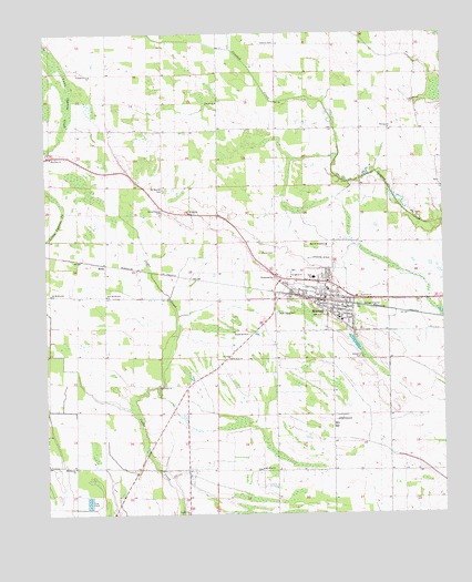
Marvell, AR USGS Topographic Map
Click on map above to begin viewing in our Map Viewer.

This topographic map contains these locations and features:
Feature Name Type Latitude Longitude GNIS ID View Map
Ashberry CemeteryCemeteryN34.5406°W90.9009°45951View Map
Ashberry ChurchChurchN34.5462°W90.9029°65584View Map
Central Church (historical)ChurchN34.6226°W90.9273°65583View Map
City of MarvellCivilN34.5563°W90.9153°2405033View Map
Corinth ChurchChurchN34.6070°W90.9462°48051View Map
Cypert ChurchChurchN34.5007°W90.9562°48287View Map
First Baptist ChurchChurchN34.5570°W90.9123°65564View Map
Gibbons AirportAirportN34.5128°W90.9740°2650717View Map
Gill CemeteryCemeteryN34.5854°W90.8751°49412View Map
Hickory Ridge Church (historical)ChurchN34.5890°W90.9740°65577View Map
HicksPopulated PlaceN34.5651°W90.9812°77179View Map
Hicks ChurchChurchN34.5654°W90.9818°65576View Map
Hicks School (historical)SchoolN34.5562°W90.9812°65575View Map
HicksvillePopulated PlaceN34.5893°W90.9751°65578View Map
King David School (historical)SchoolN34.5159°W90.9909°65574View Map
Liberty Church (historical)ChurchN34.6112°W90.9459°65582View Map
Lone Valley CemeteryCemeteryN34.5520°W90.9279°51407View Map
MarvellPopulated PlaceN34.5557°W90.9129°51716View Map
Marvell AcademySchoolN34.5701°W90.9118°51717View Map
Marvell Elementary SchoolSchoolN34.5584°W90.9115°65586View Map
Marvell Fire DepartmentBuildingN34.5569°W90.9140°2116771View Map
Marvell High SchoolSchoolN34.5615°W90.9159°65587View Map
Marvell Middle SchoolSchoolN34.5512°W90.9082°65585View Map
Marvell Police DepartmentBuildingN34.5568°W90.9140°2118599View Map
Marvell Post OfficePost OfficeN34.5565°W90.9133°2781927View Map
Marvell Primary SchoolSchoolN34.5615°W90.9171°2039284View Map
Marvell Rural Volunteer Fire DepartmentBuildingN34.5574°W90.9267°2116772View Map
Midway ChurchChurchN34.6001°W90.8918°51950View Map
Mount Mariah CemeteryCemeteryN34.5845°W90.9632°52316View Map
Mount Mariah ChurchChurchN34.5782°W90.9554°52317View Map
Mount Olive CemeteryCemeteryN34.5118°W90.9334°65579View Map
Mount Olive ChurchChurchN34.5118°W90.9326°52348View Map
Mount Olive School (historical)SchoolN34.5109°W90.9334°65580View Map
Mount Shavery CemeteryCemeteryN34.5070°W90.9918°65573View Map
Mount Shavery ChurchChurchN34.5120°W90.9912°52411View Map
Neuka Spur (historical)LocaleN34.5570°W90.9237°65581View Map
New Hope ChurchChurchN34.5407°W90.9429°52684View Map
New Zion ChurchChurchN34.5929°W90.9987°52748View Map
Old Mount Everett ChurchChurchN34.5570°W90.9987°53008View Map
Pastel CemeteryCemeteryN34.5676°W90.9282°53207View Map
Pleasant Grove ChurchChurchN34.6140°W90.9860°53541View Map
Saint Johns ChurchChurchN34.5332°W90.9648°54364View Map
Schaffhauser CemeteryCemeteryN34.5787°W90.9632°54614View Map
Township of Hickory RidgeCivilN34.5804°W90.9418°68949View Map

Note: Coordinates in the location and feature list above are referenced to NAD83 datum.


Copyright (C) 2008-2024 Ryan Niemi / Sunset Dynamics ... All Rights Reserved