TopoQuest Logo
Do you find TopoQuest useful?
Help keep TopoQuest running and adding new maps/features by donating!
Bitcoin:  19c7KJd3qBynnjoSw5npx9KScwjBe4ifkT
Litecoin:  LXs6TkuXGGXo1vDsWCkWVdjQX94eUKd6ui
Home View Maps Find Maps Find Places Resources & Links


Turner, Arkansas Topographic Map

USGS Map Title: Turner, AR
USGS Map MRC: 34091D1
DRG (GeoTIFF) Download: o34091d1.tif


Neighboring USGS Topographic Map Quads:


  Holly Grove, AR  
34091E2
 

  Pine City, AR  
34091E1
 

  Marvell, AR  
34090E8
 

  Crocketts Bluff, AR  
34091D2
 

  Turner, AR  
34091D1
 

  Watkins Corner, AR  
34090D8
 

  Ethel, AR  
34091C2
 

  Indian Bay SE, AR  
34091C1
 

  Lambrook, AR  
34090C8


Map MRC Location:

N35°
W92°
N35°
W91°
H8 H7 H6 H5 H4 H3 H2 H1
G8 G7 G6 G5 G4 G3 G2 G1
F8 F7 F6 F5 F4 F3 F2 F1
E8 E7 E6 E5 E4 E3 E2 E1
D8 D7 D6 D5 D4 D3 D2 D1
C8 C7 C6 C5 C4 C3 C2 C1
B8 B7 B6 B5 B4 B3 B2 B1
A8 A7 A6 A5 A4 A3 A2 A1
N34°
W92°
N34°
W91°

Turner, AR USGS 1:24K Topographic Map Preview:
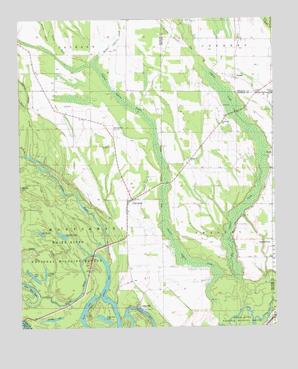
Turner, AR USGS Topographic Map
Click on map above to begin viewing in our Map Viewer.

This topographic map contains these locations and features:
Feature Name Type Latitude Longitude GNIS ID View Map
Bellknap LakeLakeN34.3785°W91.1094°76295View Map
Big Cypress CreekStreamN34.3826°W91.0154°46550View Map
Branch ChurchChurchN34.4434°W91.0412°46912View Map
Buck LakeLakeN34.3960°W91.1189°76449View Map
Connells CemeteryCemeteryN34.4059°W91.0193°47963View Map
Connells PointPopulated PlaceN34.4098°W91.0015°47964View Map
Connells Point ChurchChurchN34.4090°W91.0009°65520View Map
Connells Point School (historical)SchoolN34.4087°W91.0009°65519View Map
CreighPopulated PlaceN34.4457°W91.0007°57606View Map
Cross RoadsPopulated PlaceN34.4273°W91.0696°48203View Map
Crowfoot LakeLakeN34.3971°W91.1129°76720View Map
Dawson SloughStreamN34.4637°W91.1215°48401View Map
Eagle Nest LakeLakeN34.3784°W91.0842°76835View Map
Givins BranchStreamN34.4898°W91.0421°49426View Map
Goose LakeLakeN34.4136°W91.1149°77042View Map
Hill BayouStreamN34.4459°W91.1223°50110View Map
Hog Thief LakeLakeN34.4124°W91.1042°77193View Map
Indian BayPopulated PlaceN34.3829°W91.0671°77268View Map
Indian BayouStreamN34.4015°W91.0829°50491View Map
Israel CemeteryCemeteryN34.4631°W91.0009°50532View Map
Jacobs SlashStreamN34.4912°W91.1073°50575View Map
Little Moon LakeLakeN34.3930°W91.1228°74972View Map
MayosPopulated PlaceN34.4523°W91.0790°61117View Map
Neicy SlashStreamN34.4834°W91.0921°52601View Map
Saint John ChurchChurchN34.4487°W91.0807°54355View Map
Saint Matthew ChurchChurchN34.4579°W91.0257°54424View Map
Sandy BayouStreamN34.3879°W91.1112°54567View Map
Smalley CemeteryCemeteryN34.4165°W91.0184°54925View Map
Township of CypressCivilN34.4765°W91.0189°68948View Map
Township of Montgomery (historical)CivilN34.4126°W91.1237°68876View Map
Township of Montgomery-SmalleyCivilN34.4152°W91.0819°2406960View Map
Township of Smalley (historical)CivilN34.3959°W91.0418°68881View Map
TurnerPopulated PlaceN34.4762°W91.0187°58771View Map
Turner CemeteryCemeteryN34.4704°W91.0096°65521View Map
Turner ChurchChurchN34.4704°W91.0090°55741View Map
Turner Post OfficePost OfficeN34.4757°W91.0182°84328View Map
Turner SchoolSchoolN34.4701°W91.0001°55745View Map
Twin SloughStreamN34.4459°W91.1196°55758View Map
Valley Grove CemeteryCemeteryN34.4556°W91.0771°61119View Map
Valley Grove ChurchChurchN34.4557°W91.0785°55878View Map
Valley Grove School (historical)SchoolN34.4557°W91.0779°61118View Map
Water Bayou DamDamN34.3884°W91.1135°80156View Map
Water Bayou ReservoirReservoirN34.3879°W91.1125°80157View Map

Note: Coordinates in the location and feature list above are referenced to NAD83 datum.


Copyright (C) 2008-2025 Ryan Niemi / Sunset Dynamics ... All Rights Reserved