TopoQuest Logo
Do you find TopoQuest useful?
Help keep TopoQuest running and adding new maps/features by donating!
Bitcoin:  19c7KJd3qBynnjoSw5npx9KScwjBe4ifkT
Litecoin:  LXs6TkuXGGXo1vDsWCkWVdjQX94eUKd6ui
Home View Maps Find Maps Find Places Resources & Links


Watkins Corner, Arkansas Topographic Map

USGS Map Title: Watkins Corner, AR
USGS Map MRC: 34090D8
DRG (GeoTIFF) Download: o34090d8.tif


Neighboring USGS Topographic Map Quads:


  Pine City, AR  
34091E1
 

  Marvell, AR  
34090E8
 

  Lexa, AR  
34090E7
 

  Turner, AR  
34091D1
 

  Watkins Corner, AR  
34090D8
 

  Lakeview, AR  
34090D7
 

  Indian Bay SE, AR  
34091C1
 

  Lambrook, AR  
34090C8
 

  Elaine, AR  
34090C7


Map MRC Location:

N35°
W91°
N35°
W90°
H8 H7 H6 H5 H4 H3 H2 H1
G8 G7 G6 G5 G4 G3 G2 G1
F8 F7 F6 F5 F4 F3 F2 F1
E8 E7 E6 E5 E4 E3 E2 E1
D8 D7 D6 D5 D4 D3 D2 D1
C8 C7 C6 C5 C4 C3 C2 C1
B8 B7 B6 B5 B4 B3 B2 B1
A8 A7 A6 A5 A4 A3 A2 A1
N34°
W91°
N34°
W90°

Watkins Corner, AR USGS 1:24K Topographic Map Preview:
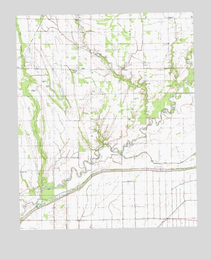
Watkins Corner, AR USGS Topographic Map
Click on map above to begin viewing in our Map Viewer.

This topographic map contains these locations and features:
Feature Name Type Latitude Longitude GNIS ID View Map
Bethlehem ChurchChurchN34.3757°W90.9848°46472View Map
Cargo SlashLakeN34.4587°W90.9771°76533View Map
Coffee CreekStreamN34.4354°W90.9082°47885View Map
Coffee Creek CemeteryCemeteryN34.4593°W90.9104°65515View Map
Coffee Creek SchoolSchoolN34.4507°W90.9171°47887View Map
CypertPopulated PlaceN34.4901°W90.9562°57621View Map
Cypert School (historical)SchoolN34.4954°W90.9562°81652View Map
Elizabeth ChurchChurchN34.4973°W90.8943°48849View Map
GobellPopulated PlaceN34.4676°W90.9251°65516View Map
Good Luck SchoolSchoolN34.4698°W90.9576°49492View Map
Gumbottom SchoolSchoolN34.4684°W90.9259°49736View Map
KingtownPopulated PlaceN34.4968°W90.8915°58022View Map
Lightfoot CemeteryCemeteryN34.4562°W90.9873°65518View Map
Little Cypress CreekStreamN34.3990°W90.9837°51257View Map
Mount Zion CemeteryCemeteryN34.4618°W90.9793°81660View Map
Mount Zion ChurchChurchN34.4612°W90.9812°52468View Map
Mount Zion School (historical)SchoolN34.4609°W90.9793°81661View Map
New Hope ChurchChurchN34.4498°W90.9173°52681View Map
Saint John ChurchChurchN34.3851°W90.9487°54354View Map
Saint Mathews ChurchChurchN34.4670°W90.9243°54421View Map
Sequell ChurchChurchN34.4968°W90.9565°54671View Map
Taylor CemeteryCemeteryN34.4387°W90.9226°65517View Map
Township of Big CreekCivilN34.4845°W90.8932°68945View Map
Township of ClevelandCivilN34.4779°W90.9722°68947View Map
Wards ChapelChurchN34.4698°W90.9876°56054View Map
Watkins CornerPopulated PlaceN34.4687°W90.9559°58835View Map
Watkins Corner Volunteer Fire DepartmentBuildingN34.4684°W90.9577°2117278View Map
Woodsdale School (historical)SchoolN34.4990°W90.9562°81672View Map

Note: Coordinates in the location and feature list above are referenced to NAD83 datum.


Copyright (C) 2008-2024 Ryan Niemi / Sunset Dynamics ... All Rights Reserved