TopoQuest Logo
Do you find TopoQuest useful?
Help keep TopoQuest running and adding new maps/features by donating!
Bitcoin:  19c7KJd3qBynnjoSw5npx9KScwjBe4ifkT
Litecoin:  LXs6TkuXGGXo1vDsWCkWVdjQX94eUKd6ui
Home View Maps Find Maps Find Places Resources & Links


Smithville, Mississippi Topographic Map

USGS Map Title: Smithville, MS
USGS Map MRC: 34088A4
DRG (GeoTIFF) Download: o34088a4.tif


Neighboring USGS Topographic Map Quads:


  Evergreen, MS  
34088B5
 

  Beans Ferry, MS  
34088B4
 

  Tremont, MS  
34088B3
 

  Nettleton, MS  
34088A5
 

  Smithville, MS  
34088A4
 

  Turon, MS  
34088A3
 

  Wren, MS  
33088H5
 

  Amory, MS  
33088H4
 

  Greenwood Springs, MS  
33088H3


Map MRC Location:

N35°
W89°
N35°
W88°
H8 H7 H6 H5 H4 H3 H2 H1
G8 G7 G6 G5 G4 G3 G2 G1
F8 F7 F6 F5 F4 F3 F2 F1
E8 E7 E6 E5 E4 E3 E2 E1
D8 D7 D6 D5 D4 D3 D2 D1
C8 C7 C6 C5 C4 C3 C2 C1
B8 B7 B6 B5 B4 B3 B2 B1
A8 A7 A6 A5 A4 A3 A2 A1
N34°
W89°
N34°
W88°

Smithville, MS USGS 1:24K Topographic Map Preview:
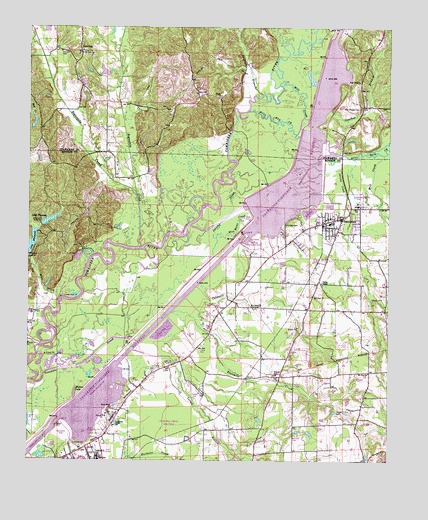
Smithville, MS USGS Topographic Map
Click on map above to begin viewing in our Map Viewer.

This topographic map contains these locations and features:
Feature Name Type Latitude Longitude GNIS ID View Map
Ales (historical)Populated PlaceN34.0246°W88.3945°709303View Map
Amory Community CenterBuildingN34.0034°W88.4784°687352View Map
Amory Golf CourseLocaleN34.0034°W88.4709°687354View Map
Amory High SchoolSchoolN34.0015°W88.4756°709306View Map
Amory Recreation AreaParkN34.0248°W88.4600°687357View Map
Antioch Church (historical)ChurchN34.0082°W88.4600°687359View Map
Bethel ChurchChurchN34.1054°W88.4334°666950View Map
Blue Water CreekStreamN34.0643°W88.4348°667326View Map
Boguefala CreekStreamN34.0615°W88.4620°667398View Map
Boguegaba CreekStreamN34.0773°W88.4628°667399View Map
Bull Mountain CreekStreamN34.1009°W88.4242°115180View Map
Caldwell BranchStreamN34.0404°W88.4556°667914View Map
CarolinaPopulated PlaceN34.1184°W88.4820°668072View Map
Coaches BranchStreamN34.1168°W88.4103°668620View Map
Conwill CemeteryCemeteryN34.1182°W88.4889°668776View Map
Dunlap CemeteryCemeteryN34.0684°W88.4109°669514View Map
Emmaus ChurchChurchN34.1032°W88.4748°669768View Map
English BranchStreamN34.1054°W88.4192°669779View Map
Evergreen - Carolina Volunteer Fire Department Station 301BuildingN34.1184°W88.4827°2666034View Map
FlinnPopulated PlaceN34.0462°W88.4292°711137View Map
Floyton (historical)Populated PlaceN34.0051°W88.3842°709336View Map
Fourmile CreekStreamN34.0354°W88.4653°670137View Map
Hadaway CreekStreamN34.0712°W88.3764°670819View Map
Jericho CreekStreamN34.0546°W88.4412°671848View Map
Lake ThomasReservoirN34.0694°W88.4925°678683View Map
Lake Thomas DamDamN34.0684°W88.4967°682449View Map
Lake WhitesideReservoirN34.0630°W88.4986°679642View Map
Malone LakeLakeN34.0192°W88.4837°673106View Map
Mill CreekStreamN34.0884°W88.3773°673609View Map
Mill CreekStreamN34.1084°W88.4131°673610View Map
Mill CreekStreamN34.0471°W88.4875°673628View Map
Mount Zion ChurchChurchN34.0257°W88.3817°674394View Map
New ChapelChurchN34.1096°W88.3856°674603View Map
New Chapel CemeteryCemeteryN34.1018°W88.3853°674605View Map
New Prospect ChurchChurchN34.0248°W88.4150°674815View Map
Poison PondReservoirN34.0334°W88.4728°711138View Map
Pool BReservoirN34.0873°W88.4055°682448View Map
Pooles Chapel Christian Methodist ChurchChurchN34.0515°W88.3981°676206View Map
Section CreekStreamN34.0712°W88.3767°677497View Map
SmithvillePopulated PlaceN34.0701°W88.3912°677945View Map
Smithville Baptist ChurchChurchN34.0709°W88.3937°709386View Map
Smithville CemeteryCemeteryN34.0709°W88.3945°687464View Map
Smithville Church of ChristChurchN34.0657°W88.3937°709387View Map
Smithville Fire DepartmentBuildingN34.0690°W88.3978°2665765View Map
Smithville Freewill Baptist ChurchChurchN34.0626°W88.4078°709388View Map
Smithville Methodist ChurchChurchN34.0712°W88.3925°709389View Map
Smithville Police DepartmentBuildingN34.0690°W88.3978°2754202View Map
Smithville Recreation AreaParkN34.0618°W88.4209°687465View Map
Supervisor District 1CivilN34.0334°W88.4024°711987View Map
Town of SmithvilleCivilN34.0680°W88.3982°2407354View Map
Trace Road Independent Baptist ChurchChurchN34.0151°W88.4709°678851View Map
Turner BranchStreamN34.0284°W88.4489°678969View Map

Note: Coordinates in the location and feature list above are referenced to NAD83 datum.


Copyright (C) 2008-2025 Ryan Niemi / Sunset Dynamics ... All Rights Reserved