TopoQuest Logo
Do you find TopoQuest useful?
Help keep TopoQuest running and adding new maps/features by donating!
Bitcoin:  19c7KJd3qBynnjoSw5npx9KScwjBe4ifkT
Litecoin:  LXs6TkuXGGXo1vDsWCkWVdjQX94eUKd6ui
Home View Maps Find Maps Find Places Resources & Links


Turon, Mississippi Topographic Map

USGS Map Title: Turon, MS
USGS Map MRC: 34088A3
DRG (GeoTIFF) Download: o34088a3.tif


Neighboring USGS Topographic Map Quads:


  Beans Ferry, MS  
34088B4
 

  Tremont, MS  
34088B3
 

  Bexar, AL  
34088B2
 

  Smithville, MS  
34088A4
 

  Turon, MS  
34088A3
 

  Detroit, AL  
34088A2
 

  Amory, MS  
33088H4
 

  Greenwood Springs, MS  
33088H3
 

  Sulligent, AL  
33088H2


Map MRC Location:

N35°
W89°
N35°
W88°
H8 H7 H6 H5 H4 H3 H2 H1
G8 G7 G6 G5 G4 G3 G2 G1
F8 F7 F6 F5 F4 F3 F2 F1
E8 E7 E6 E5 E4 E3 E2 E1
D8 D7 D6 D5 D4 D3 D2 D1
C8 C7 C6 C5 C4 C3 C2 C1
B8 B7 B6 B5 B4 B3 B2 B1
A8 A7 A6 A5 A4 A3 A2 A1
N34°
W89°
N34°
W88°

Turon, MS USGS 1:24K Topographic Map Preview:
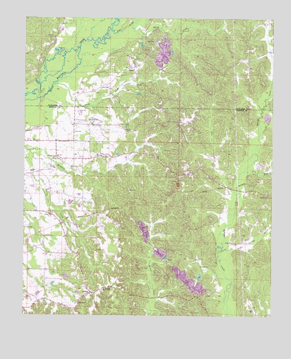
Turon, MS USGS Topographic Map
Click on map above to begin viewing in our Map Viewer.

This topographic map contains these locations and features:
Feature Name Type Latitude Longitude GNIS ID View Map
Ashcraft School (historical)SchoolN34.0368°W88.2931°687360View Map
Bethlehem ChurchChurchN34.0498°W88.2517°667021View Map
Bluff CreekStreamN34.0962°W88.3617°667330View Map
BristowPopulated PlaceN34.0054°W88.3639°687368View Map
Burdine CemeteryCemeteryN34.0668°W88.3592°667798View Map
Cowley CemeteryCemeteryN34.0782°W88.3236°668902View Map
Dry CreekStreamN34.0518°W88.2667°669424View Map
Dyer CemeteryCemeteryN34.1154°W88.3159°669537View Map
Gilliland CemeteryCemeteryN34.0209°W88.2814°670391View Map
Hathcock CemeteryCemeteryN34.0604°W88.2936°671009View Map
Ironwood Bluff (historical)LocaleN34.1098°W88.3667°685194View Map
Jims CreekStreamN34.1201°W88.3334°671885View Map
Jones CemeteryCemeteryN34.0773°W88.3506°671974View Map
Lick BranchStreamN34.0609°W88.2650°672477View Map
Lindsey CemeteryCemeteryN34.0509°W88.3470°672506View Map
Little Splunge CreekStreamN34.0276°W88.2748°672690View Map
Maxie CemeteryCemeteryN34.0626°W88.3486°673252View Map
Miston (historical)LocaleN34.1140°W88.2875°706250View Map
Monroe Sporting Club Lake DamDamN34.1134°W88.3150°682473View Map
New Hope Baptist ChurchChurchN34.0098°W88.3412°709364View Map
New Hope CemeteryCemeteryN34.0051°W88.3484°709365View Map
New Hope Church of ChristChurchN34.0051°W88.3470°674732View Map
ParhamPopulated PlaceN34.0098°W88.3406°675443View Map
Pearce ChurchChurchN34.0673°W88.3370°675536View Map
Pecks Shop (historical)LocaleN34.0473°W88.2931°687447View Map
Pickle CemeteryCemeteryN34.0307°W88.2700°675713View Map
Riggan CemeteryCemeteryN34.0026°W88.2584°676661View Map
RigginsPopulated PlaceN34.0507°W88.2528°711139View Map
Rye FieldAirportN34.0512°W88.3694°680419View Map
Silome CemeteryCemeteryN34.0659°W88.3575°677786View Map
Smith CemeteryCemeteryN34.0348°W88.2631°677910View Map
Smith CreekStreamN34.1209°W88.3234°677924View Map
Splunge Lookout TowerTowerN34.0118°W88.3312°711315View Map
Springfield CemeteryCemeteryN34.0829°W88.3434°678169View Map
TuronPopulated PlaceN34.1043°W88.3250°678985View Map
W A Gideon Lake DamDamN34.0201°W88.2850°682439View Map
Wylie CemeteryCemeteryN34.0959°W88.3378°679903View Map

Note: Coordinates in the location and feature list above are referenced to NAD83 datum.


Copyright (C) 2008-2025 Ryan Niemi / Sunset Dynamics ... All Rights Reserved