TopoQuest Logo
Do you find TopoQuest useful?
Help keep TopoQuest running and adding new maps/features by donating!
Bitcoin:  19c7KJd3qBynnjoSw5npx9KScwjBe4ifkT
Litecoin:  LXs6TkuXGGXo1vDsWCkWVdjQX94eUKd6ui
Home View Maps Find Maps Find Places Resources & Links


Mather, Pennsylvania Topographic Map

USGS Map Title: Mather, PA
USGS Map MRC: 39080H1
DRG (GeoTIFF) Download: o39080h1.tif


Neighboring USGS Topographic Map Quads:


  Amity, PA  
40080A2
 

  Ellsworth, PA  
40080A1
 

  California, PA  
40079A8
 

  Waynesburg, PA  
39080H2
 

  Mather, PA  
39080H1
 

  Carmichaels, PA  
39079H8
 

  Oak Forest, PA  
39080G2
 

  Garards Fort, PA  
39080G1
 

  Masontown, PA  
39079G8


Map MRC Location:

N40°
W81°
N40°
W80°
H8 H7 H6 H5 H4 H3 H2 H1
G8 G7 G6 G5 G4 G3 G2 G1
F8 F7 F6 F5 F4 F3 F2 F1
E8 E7 E6 E5 E4 E3 E2 E1
D8 D7 D6 D5 D4 D3 D2 D1
C8 C7 C6 C5 C4 C3 C2 C1
B8 B7 B6 B5 B4 B3 B2 B1
A8 A7 A6 A5 A4 A3 A2 A1
N39°
W81°
N39°
W80°

Mather, PA USGS 1:24K Topographic Map Preview:
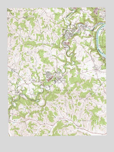
Mather, PA USGS Topographic Map
Click on map above to begin viewing in our Map Viewer.

This topographic map contains these locations and features:
Feature Name Type Latitude Longitude GNIS ID View Map
Bacon RunStreamN39.9656°W80.0784°1212735View Map
Bates RunStreamN39.9613°W80.0087°1168806View Map
BescoPopulated PlaceN39.9851°W80.0237°1203073View Map
Black Dog HollowValleyN39.9849°W80.0107°1169700View Map
Borough of ClarksvilleCivilN39.9744°W80.0439°1215253View Map
Borough of JeffersonCivilN39.9305°W80.0577°1215255View Map
Braden PlanPopulated PlaceN39.9695°W80.0467°1170127View Map
Browns RunStreamN39.9279°W80.0751°1170396View Map
Browns Run DamDamN39.9284°W80.0764°1194431View Map
Browns Run PortalMineN39.9504°W80.0953°1170406View Map
Browns Run ReservoirReservoirN39.9295°W80.0761°1194430View Map
Burson PlanPopulated PlaceN39.9676°W80.0498°1170756View Map
Calvary ChurchChurchN39.9398°W80.1195°1170923View Map
Castile RunStreamN39.9623°W80.0534°1171317View Map
Central SchoolSchoolN39.9315°W80.0620°1171493View Map
ChartiersPopulated PlaceN39.9581°W80.0509°1171597View Map
ClarksvillePopulated PlaceN39.9729°W80.0439°1171935View Map
Clarksville HillPopulated PlaceN39.9823°W80.0389°1171936View Map
Clarksville Post OfficePost OfficeN39.9735°W80.0448°2779853View Map
Clarksville Volunteer Fire Department Company 19BuildingN39.9742°W80.0434°2645265View Map
Clyde 3 PortalMineN39.9790°W80.1089°1172041View Map
Coal Lick RunStreamN39.9048°W80.1187°1192281View Map
Cumberland CemeteryCemeteryN39.9315°W80.0623°1172826View Map
Douglass GreenhouseBuildingN39.8894°W80.0431°2650604View Map
Dry TavernPopulated PlaceN39.9392°W80.0123°1173556View Map
Dry Tavern Census Designated PlaceCensusN39.9399°W80.0095°2634213View Map
Eaton HollowValleyN39.8919°W80.0500°1173938View Map
Edwards Shaft PortalMineN39.9642°W80.0539°1174035View Map
Emerald MineMineN39.9701°W80.0128°1174216View Map
Fredericktown-Millsboro Census Designated Place (historical)CensusN39.9966°W80.0061°2389813View Map
Greene County Home (historical)BuildingN39.8890°W80.1245°1209120View Map
Greene County Memorial ParkCemeteryN39.9295°W80.0907°1209122View Map
Greene County MuseumBuildingN39.8892°W80.1245°1209280View Map
Grimes RunStreamN39.9390°W80.1198°1176238View Map
JeffersonPopulated PlaceN39.9301°W80.0589°1178007View Map
Jefferson Post OfficePost OfficeN39.9305°W80.0591°2779663View Map
Jefferson Volunteer Fire Department Company 20BuildingN39.9342°W80.0550°2645121View Map
Jefferson-Morgan High SchoolSchoolN39.9284°W80.0642°1178026View Map
KhedivePopulated PlaceN39.8840°W80.0362°1178440View Map
LippincottPopulated PlaceN39.9390°W80.1189°1179446View Map
MatherPopulated PlaceN39.9348°W80.0737°1180545View Map
Mather Census Designated PlaceCensusN39.9356°W80.0751°2630023View Map
Mather Post OfficePost OfficeN39.9346°W80.0734°2779966View Map
Milfred TerracePopulated PlaceN39.9909°W80.0026°1181110View Map
Millsboro Census Designated PlaceCensusN39.9901°W80.0022°2584486View Map
Mount Zion CemeteryCemeteryN39.9896°W80.1245°1181897View Map
Muddy Creek ChurchChurchN39.8912°W80.0584°1182046View Map
Pitt GasPopulated PlaceN39.9801°W80.0278°1183976View Map
Pollock CemeteryCemeteryN39.8903°W80.0878°1184213View Map
Pumpkin Run County ParkParkN39.9454°W80.0014°1209267View Map
Rices Landing Post OfficePost OfficeN39.9398°W80.0109°2779975View Map
Rohannas Golf CourseLocaleN39.8912°W80.1164°1205578View Map
Ruff CreekStreamN39.9159°W80.1053°1185601View Map
Rush RunStreamN39.9610°W80.0112°1185642View Map
Sandy PlainsPopulated PlaceN39.9979°W80.0292°1204582View Map
Shady LakeReservoirN39.9156°W80.0175°1187305View Map
Smith CemeteryCemeteryN39.9128°W80.1178°1187857View Map
South Branch Muddy CreekStreamN39.8815°W80.0020°1209364View Map
South Fork Tenmile CreekStreamN39.9742°W80.0398°1193409View Map
Stony PointPopulated PlaceN39.9270°W80.0823°1188782View Map
Teagarden HomesPopulated PlaceN39.9762°W80.0492°1189332View Map
Township of East BethlehemCivilN39.9950°W80.0162°1217190View Map
Township of JeffersonCivilN39.9219°W80.0518°1216493View Map
Township of MorganCivilN39.9577°W80.0942°1216495View Map
Wayne TunnelTunnelN39.9101°W80.1178°1190718View Map
WilliamstownPopulated PlaceN39.9792°W80.0409°1191490View Map
Winnett ChurchChurchN39.9981°W80.1242°1191602View Map
Youth Development CenterBuildingN39.9184°W80.1131°1209121View Map

Note: Coordinates in the location and feature list above are referenced to NAD83 datum.


Copyright (C) 2008-2024 Ryan Niemi / Sunset Dynamics ... All Rights Reserved